1990s Maps of Douglas County, Nevada
Explore 6 historic maps of Douglas County from the 1990s. These maps offer a rare glimpse into what life looked like during the 1990s — showing old roads, neighborhoods, homes, and landmarks that have changed or disappeared over time.
Whether you're researching your family's past, planning a metal detecting trip, or studying how Douglas County's landscape evolved across the 1990s, these high-resolution maps are a powerful tool for exploring the history of this region.
- Focus on a specific era: All maps on this page are from the 1990s, giving you a focused view of this time period.
- See what’s changed: Compare century-old streets, trails, and buildings to today's modern landscape using overlays and satellite layers.
- Research with precision: Use these maps for genealogy, historical research, land use analysis, or educational projects.
- View, download, or print: Maps are fully viewable online in high resolution, and can be downloaded or printed for your own records.
Start exploring Douglas County's history through authentic maps from the 1990s. This is your window into the past.
Douglas County, NV maps
(6)- 1992 Map of Meeks Bay, 1994 Print
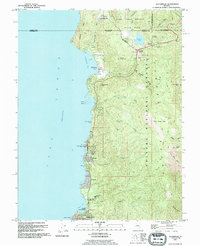
 1992 Meeks Bay1994 Print · USGSThe West Shore of Lake Tahoe in the early nineties reveals a landscape of lakeside communities and protected state parklands. Researchers can trace the development of Tahoma, locate the historic Ehrman Mansion, and identify recreation sites like Meeks Bay Campground.
 - 1992 Map of Glenbrook, 1994 Print
 1992 Glenbrook1994 Print · USGSThe eastern shore of Lake Tahoe in the early nineties shows a landscape of growing mountain communities and protected forest land. Local historians can trace the development of Lincoln Park and Skyland or locate landmarks like Cave Rock and the Spooner Guard Station.2 unique versions available
 - 1992 Map of Emerald Bay, 1994 Print
 1992 Emerald Bay1994 Print · USGSThe southwestern shores of Lake Tahoe in the early nineties show a landscape of landmark estates and expanding mountain settlements. Researchers can trace the development of Tallac Village, locate the historic Vikingsholm estate, and follow the Pacific Crest National Scenic Trail.
 - 1992 Map of South Lake Tahoe, 1994 Print
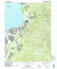 1992 South Lake Tahoe1994 Print · USGSSouth Lake Tahoe is shown in the early nineties as a bustling cross-border hub of recreation and commerce. Trace the historic Von Schmidt Line, find local landmarks like Happy Homestead Cem, or explore the development around Stateline.
 - 1994 Map of Genoa
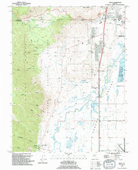 1994 Genoa1994 Print · USGSGenoa and the surrounding Carson Valley are captured in the mid-1990s, showcasing the intersection of pioneer history and modern Nevada infrastructure. Researchers can trace early settlements at the Morman Station Historic State Mon or locate the Jacks Valley Cem and Hobo Hot Springs.
 - 1994 Map of McTarnahan Hill
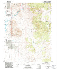 1994 McTarnahan Hill1994 Print · USGSThe Nevada high desert at the edge of the Carson Valley comes to life in this mid-1990s survey. Genealogists and local historians can trace the developments around the Northern Nevada Correctional Center or locate the historic McTarnahan Bridge (Site) and Bunker Hill Mine.
End of results
Showing maps 1-6 of 6
Top cities of Douglas County
- Gardnerville Ranchos historical maps
- Johnson Lane historical maps
- Indian Hills historical maps
- Minden historical maps
- Kingsbury historical maps
- Topaz Ranch Estates historical maps
See more
Frequently asked questions
- What are the different types of historical maps available for Douglas County?
- What is the oldest map of Douglas County?
- Where can I purchase historical maps of Douglas County for my home or office?
- Where can I download high-res historical maps of Douglas County?
- Are there historical topographic maps available for Douglas County?
- Is there historical aerial imagery available for Douglas County?
- Where are historical maps of Douglas County sourced from?