1990s Maps of Esmeralda County, Nevada
Explore 10 historic maps of Esmeralda County from the 1990s. These maps offer a rare glimpse into what life looked like during the 1990s — showing old roads, neighborhoods, homes, and landmarks that have changed or disappeared over time.
Whether you're researching your family's past, planning a metal detecting trip, or studying how Esmeralda County's landscape evolved across the 1990s, these high-resolution maps are a powerful tool for exploring the history of this region.
- Focus on a specific era: All maps on this page are from the 1990s, giving you a focused view of this time period.
- See what’s changed: Compare century-old streets, trails, and buildings to today's modern landscape using overlays and satellite layers.
- Research with precision: Use these maps for genealogy, historical research, land use analysis, or educational projects.
- View, download, or print: Maps are fully viewable online in high resolution, and can be downloaded or printed for your own records.
Start exploring Esmeralda County's history through authentic maps from the 1990s. This is your window into the past.
Esmeralda County, NV maps
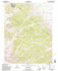
(10)- 1994 Map of Davis Mountain, 1997 Print
 1994 Davis Mountain1997 Print · USGSThe Nevada-California borderlands come into focus in the mid-1990s as the high-desert terrain meets the Inyo National Forest. Researchers can trace the historic Von Schmidt Line and locate remote sites like the Mollini Mine or the settlement at McNett.
 - 1994 Map of Volcanic Hills West, 1997 Print
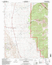
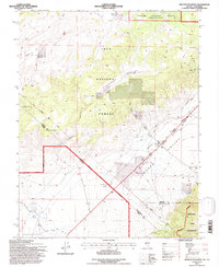
 1994 Volcanic Hills West1997 Print · USGSEsmeralda County, Nevada, as it appeared in the mid-1990s, reveals a remote high-desert landscape defined by mining activity and the rugged eastern boundary of the Inyo National Forest. Historians and prospectors can trace the location of the F and L Mine, explore the heights of Pinyon Hill, and follow the winding path of Sand Spring Canyon.
 - 1994 Map of Station Peak, 1997 Print
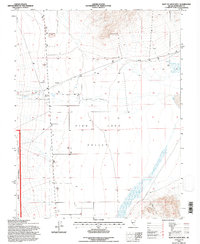
 1994 Station Peak1997 Print · USGSThe high desert borderlands of Mono County and Nevada are captured here in the mid-1990s, revealing a landscape defined by the Von Schmidt Line. Researchers can trace the 1872 state boundary or locate remote sites like Station Peak, the valley Landing Strip, and several high-altitude Spring water sources.
 - 1994 Map of Dyer, 1997 Print
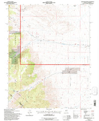
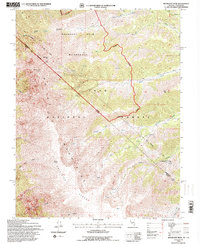
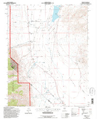 1994 Dyer1997 Print · USGSFish Lake Valley in the mid-1990s shows a high-desert community defined by its remote location and water management. Genealogists and historians can locate the Dyer settlement, including the Dyer Sch, and trace the historic Von Schmidt Line.
 - 1994 Map of East of Davis Mtn., 1997 Print
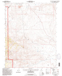
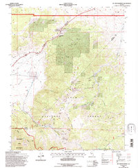
 1994 East of Davis Mtn.1997 Print · USGSEsmeralda County, Nevada, is captured in the mid-1990s as a landscape of high-desert ranching and geothermal potential. Genealogists and researchers can trace the remote outpost of Fishlake and locate specialized infrastructure like the Landing Strip and a Geothermal Well.
 - 1994 Map of Mt. Montgomery, 1997 Print
 1994 Mt. Montgomery1997 Print · USGSThe Nevada-California borderlands of the mid-nineties reveal a landscape defined by high-desert mining and infrastructure. Trace the operations at the Queen Canyon Mine, follow the Old Railroad Grade, and locate the Gold Hit site near the Pinchot Canyon.
 - 1994 Map of Boundary Peak, 1997 Print
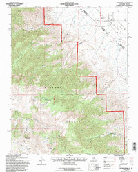
 1994 Boundary Peak1997 Print · USGSThe high Sierra borderlands are mapped in the 1990s, featuring the intersection of the Nevada-California state line and the Von Schmidt Line. Trace historic survey monuments like Cal-Nev Mon #60 and the remote reaches of Chiatovich Creek.
 - 1994 Map of Benton, 1997 Print
 1994 Benton1997 Print · USGSThe high desert of Mono County and the Nevada borderlands are captured here in the mid-nineties. Genealogists and researchers can trace old mining sites like Montgomery City, the Black Warrior Mine, and the historic Von Schmidt Line.
 - 1994 Map of Truman Meadows, 1997 Print
 1994 Truman Meadows1997 Print · USGSThe California-Nevada borderlands near Truman Meadows are captured here in the mid-1990s as they transition from historic mining districts to protected wilderness. Researchers can trace the diagonal Von Schmidt Line and locate remote landmarks like the Open Pit Mine, an isolated Landing Strip, and State Mon No 58.
 - 1994 Map of Juniper Mountain, 1998 Print
 1994 Juniper Mountain1998 Print · USGSThe California-Nevada state line cuts through the high White Mountains during the mid-nineties, marking a landscape of remote peaks and legacy mining claims. Researchers can trace the historic Von Schmidt Line (1873) and locate the high-altitude Evergreen Mine or the Green Monster Mine.
End of results
Showing maps 1-10 of 10
Top cities of Esmeralda County
- Dyer historical maps
- Goldfield historical maps
- Silver Peak historical maps
- Gold Point historical maps
- Lida historical maps
Frequently asked questions
- What are the different types of historical maps available for Esmeralda County?
- What is the oldest map of Esmeralda County?
- Where can I purchase historical maps of Esmeralda County for my home or office?
- Where can I download high-res historical maps of Esmeralda County?
- Are there historical topographic maps available for Esmeralda County?
- Is there historical aerial imagery available for Esmeralda County?
- Where are historical maps of Esmeralda County sourced from?