1990s Maps of Lyon County, Nevada
Explore 4 historic maps of Lyon County from the 1990s. These maps offer a rare glimpse into what life looked like during the 1990s — showing old roads, neighborhoods, homes, and landmarks that have changed or disappeared over time.
Whether you're researching your family's past, planning a metal detecting trip, or studying how Lyon County's landscape evolved across the 1990s, these high-resolution maps are a powerful tool for exploring the history of this region.
- Focus on a specific era: All maps on this page are from the 1990s, giving you a focused view of this time period.
- See what’s changed: Compare century-old streets, trails, and buildings to today's modern landscape using overlays and satellite layers.
- Research with precision: Use these maps for genealogy, historical research, land use analysis, or educational projects.
- View, download, or print: Maps are fully viewable online in high resolution, and can be downloaded or printed for your own records.
Start exploring Lyon County's history through authentic maps from the 1990s. This is your window into the past.
Lyon County, NV maps
(4)- 1993 Map of Dayton
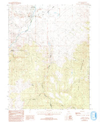 1993 Dayton1993 Print · USGSDayton and the surrounding Comstock foothills appear in the early nineties as a landscape defined by its mining heritage and river valley life. Researchers can trace the town's layout near Dayton State Park and locate numerous hillside prospects, a Mine Shaft, and the old Cem.
 - 1994 Map of New Empire
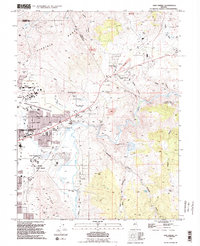 1994 New Empire1994 Print · USGSEastern Carson City and the rugged foothills of the Virginia Range are captured in the mid-1990s as the state capital expanded toward its historic mining districts. Researchers can find landmarks like the Nevada State Prison and the Old Mexican Mill, along with the site of Mound House.2 unique versions available
 - 1994 Map of Flowery Peak
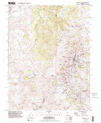
 1994 Flowery Peak1994 Print · USGSStorey County's mining heritage is on full display here in the 1990s, from the high peaks of the Flowery Range down to the Carson River. You can trace the path of the Sutro Tunnel and locate historical sites like the Berry Glory Hole and Monte Cristo (Site).
 - 1994 Map of Virginia City
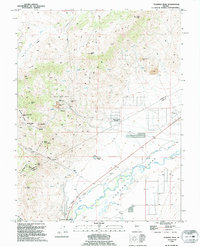
 1994 Virginia City1994 Print · USGSThe Comstock Lode district is preserved in this late-century survey, detailing the mining heart of Nevada. Genealogists and historians can trace the foundations of Virginia City through landmarks like the 4th Ward Sch Museum and numerous historic plots including the Masonic Cem.2 unique versions available
End of results
Showing maps 1-4 of 4
Top cities of Lyon County
- Fernley historical maps
- Dayton historical maps
- Silver Springs historical maps
- Yerington historical maps
- Stagecoach historical maps
- Smith Valley historical maps
See more
Frequently asked questions
- What are the different types of historical maps available for Lyon County?
- What is the oldest map of Lyon County?
- Where can I purchase historical maps of Lyon County for my home or office?
- Where can I download high-res historical maps of Lyon County?
- Are there historical topographic maps available for Lyon County?
- Is there historical aerial imagery available for Lyon County?
- Where are historical maps of Lyon County sourced from?