1960s Maps of Mineral County, Nevada
Explore 29 historic maps of Mineral County from the 1960s. These maps offer a rare glimpse into what life looked like during the 1960s — showing old roads, neighborhoods, homes, and landmarks that have changed or disappeared over time.
Whether you're researching your family's past, planning a metal detecting trip, or studying how Mineral County's landscape evolved across the 1960s, these high-resolution maps are a powerful tool for exploring the history of this region.
- Focus on a specific era: All maps on this page are from the 1960s, giving you a focused view of this time period.
- See what’s changed: Compare century-old streets, trails, and buildings to today's modern landscape using overlays and satellite layers.
- Research with precision: Use these maps for genealogy, historical research, land use analysis, or educational projects.
- View, download, or print: Maps are fully viewable online in high resolution, and can be downloaded or printed for your own records.
Start exploring Mineral County's history through authentic maps from the 1960s. This is your window into the past.
Mineral County, NV maps
(29)- 1960 Map of Reno
 1960 Reno1960 Print · USGSThe high desert of western Nevada comes alive in this mid-century survey of the Reno-Tahoe region. Genealogists and historians can trace rail lines like the Southern Pacific RR and locate remote outposts such as Olinghouse, Nixon, and the Olinghouse Mine.2 unique versions available
 - 1962 Map of Walker Lake
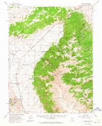
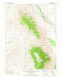
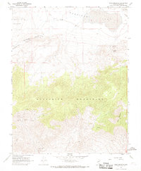
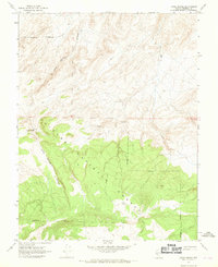
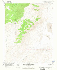
 1962 Walker Lake1962 Print · USGSThe high desert of western Nevada and the Sierra Nevada crest meet in this mid-century study of the Eastern Sierra frontier. Researchers can trace the Southern Pacific rail lines connecting Hawthorne to remote mining outposts like Bodie, Aurora, and Mina.
 - 1962 Map of Tonopah
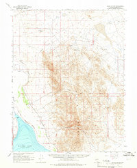
 1962 Tonopah1962 Print · USGSCentral Nevada's high desert mining country is captured here during the early sixties, showing the enduring footprint of the silver and gold rushes. Researchers can trace the decline of historic camps and locate industrial sites like the Tybo Mine, Victory Tungsten Mine, and the Mt. Moriah Cemetery.2 unique versions available
 - 1962 Map of Benton, 1964 Print
 1962 Benton1964 Print · USGSBenton and the surrounding White Mountain high desert are captured in the early sixties as a landscape of remote ranches and remnant mines. Researchers can trace the Old Railroad Grade and locate historic sites like Montgomery City and the Buckskin Mine.2 unique versions available
 - 1962 Map of Glass Mountain, 1964 Print
 1962 Glass Mountain1964 Print · USGSThe high basins and volcanic peaks of Mono County are captured here in the early sixties as a landscape of remote ranches and mining claims. Genealogists and historians can trace family-named sites like Dutch Petes Ranch, the Pizona townsite, and the geothermal area of Benton Hot Springs.2 unique versions available
 - 1963 Map of Mariposa
 1963 Mariposa1963 Print · USGSThe High Sierra and Owens Valley meet in the early sixties, showing a landscape defined by gold-rush history and massive post-war water projects. Genealogists and researchers can trace old mining routes near Mariposa, locate the Glacier Point Hotel, and find small settlements like Coarse Gold or Knowles Junction.
 - 1963 Map of Davis Mountain, 1965 Print
 1963 Davis Mountain1965 Print · USGSThe Nevada-California border country in the early sixties is shown here as a landscape of isolated ranches and high-desert mines. Researchers can locate the Dyer Ranch, follow the waters of Chiatovich Creek, and trace old trails past the Red Rock Mine.2 unique versions available
 - 1964 Map of Walker Lake
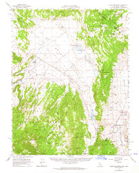
 1964 Walker Lake1964 Print · USGSThe high desert and the Sierra Nevada peaks come together in the mid-1960s, showing a landscape defined by mining, military installations, and vast wilderness. Genealogists and historians can trace the remnants of old mining camps at Bodie or Candelaria and follow the Southern Pacific rail lines.2 unique versions available
 - 1964 Map of Gillis Canyon, 1966 Print
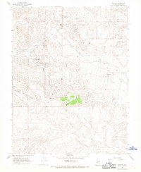
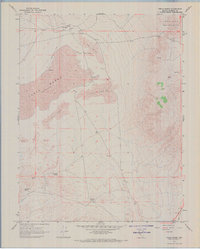
 1964 Gillis Canyon1966 Print · USGSMineral County's high desert and the northern reaches of the Walker River basin are captured here in the mid-1960s. Researchers can trace the path of the Southern Pacific and the operations at Red Granite Mine or Gentry Mine.2 unique versions available
 - 1964 Map of Schurz, 1966 Print
 1964 Schurz1966 Print · USGSThe community of Schurz and the surrounding reservation land are documented here in the mid-1960s as a vital desert crossroads. Genealogists and historians can trace the Southern Pacific line past the Hospital or locate mining sites like Northern Lights Mine.2 unique versions available
 - 1967 Map of Pamlico, 1969 Print
 1967 Pamlico1969 Print · USGSMineral County mining history is preserved on this late 1960s survey, showing the transition from old mining camps to military land use. Trace prospector trails to Pamlico or locate old claims like the Evening Star Mine and Sunset Mine.2 unique versions available
 - 1967 Map of Columbus, 1969 Print
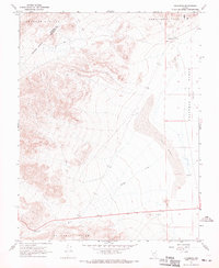 1967 Columbus1969 Print · USGSEsmeralda County's high desert reveals its mining and salt-harvesting roots in the late sixties. Trace the rugged terrain from Columbus to the Columbus Salt Marsh (Alkali Flat) while locating remote Mine and Prospects sites.3 unique versions available
 - 1967 Map of Miller Mountain, 1969 Print
 1967 Miller Mountain1969 Print · USGSThe high desert of Mineral and Esmeralda counties comes into focus during the late 1960s, showing a landscape shaped by mining and technical infrastructure. Researchers can trace historic claims at the Maxfield Mine, locate the path of an Aqueduct, and follow remote routes like the Jeep Trail across the Candelaria Hills.2 unique versions available
 - 1967 Map of Moho Mountain, 1969 Print
 1967 Moho Mountain1969 Print · USGSMineral County mining activity reached into these high basins during the late 1960s, leaving a detailed record of remote mountain prospects. Trace old access routes to the Marietta Mines, Garfield Mill (Site), and ancient petroglyphs.3 unique versions available
 - 1967 Map of Basalt, 1969 Print
 1967 Basalt1969 Print · USGSMineral County mining and transit history are preserved here in the late sixties, centered on the small settlement of Basalt. Local history researchers can trace the Old Railroad Grade and locate mining sites like Eastside Mine or the Noguez Mine.4 unique versions available
 - 1967 Map of Candelaria, 1969 Print
 1967 Candelaria1969 Print · USGSHigh desert mining history comes alive in this late 1960s survey of the Candelaria Hills. Genealogists and historians can trace the sites of Candelaria (Site) and Metallic City (Site), along with the Candelaria Cem and the Northern Belle Mine.2 unique versions available
 - 1967 Map of Mina NW, 1969 Print
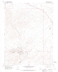
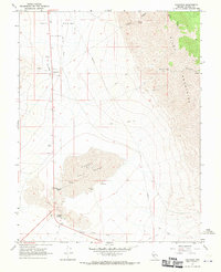
 1967 Mina NW1969 Print · USGSMineral County in the late 1960s is a landscape of high desert mining and rail transport. Researchers can trace the industrial footprint of the Blue Ribbon Mine and Kay Mine or follow the Southern Pacific railroad as it crosses the Alkali Flat.3 unique versions available
 - 1967 Map of Jacks Spring, 1969 Print
 1967 Jacks Spring1969 Print · USGSMineral County, Nevada, is captured in the late sixties as a high-desert wilderness defined by the Toiyabe National Forest boundary. Researchers can trace remote routes like the Jeep Trail to isolated landmarks such as Jacks Spring and a lonely Cabin.2 unique versions available
 - 1967 Map of Teels Marsh, 1969 Print
 1967 Teels Marsh1969 Print · USGSMineral County mining and desert life are visible in the late sixties as industrial activity centers on the alkali basin. Researchers can locate the small settlement of Marietta, its Cem, and remote water sources like Rock House Spring and German Spring.2 unique versions available
 - 1967 Map of Belleville, 1969 Print
 1967 Belleville1969 Print · USGSMining history and rail archaeology define this Nevada landscape in the late sixties. Researchers can trace the industrial remnants of Belleville (Site), the Old RR Grade, and family-linked sites like the Giroux Mine.3 unique versions available
 - 1967 Map of Sodaville, 1970 Print
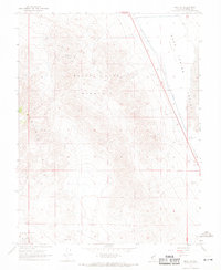
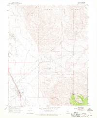
 1967 Sodaville1970 Print · USGSSoda Spring Valley in the late 1960s was a landscape shaped by mining and the desert railroad. Researchers can trace the Old Railroad Grade and locate old sites like Sodaville, Rhodes (Site), and the Cem near the salt marsh.2 unique versions available
 - 1967 Map of Little Huntoon Valley, 1970 Print
 1967 Little Huntoon Valley1970 Print · USGSMineral County's high desert is captured here in the late sixties, showing a landscape of mineral exploration and remote ridges. Trace the trails to isolated mining operations like the Pine Crow Mine, Defender Mine, and the desolate white expanse of Teels Marsh.2 unique versions available
 - 1967 Map of Camp Douglas, 1970 Print
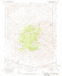
 1967 Camp Douglas1970 Print · USGSMineral County mining was in full swing during the late sixties, centered on the high-desert claims of the Excelsior Mountains. Researchers can locate dozens of specific workings including the Maryann Mine, Orphan Boy Mine, and the settlement at Camp Douglas.2 unique versions available
 - 1967 Map of Rattlesnake Flat, 1970 Print
 1967 Rattlesnake Flat1970 Print · USGSHigh-desert Mineral County appears here in the late sixties, showing the rugged corridor between the Garfield Hills and the Excelsior Mountains. Trace historic water sources and transit routes such as Rattlesnake Well, Summit Spring, and the old Pack Trail.3 unique versions available
 - 1967 Map of Mina, 1970 Print
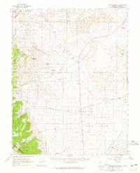
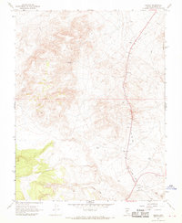
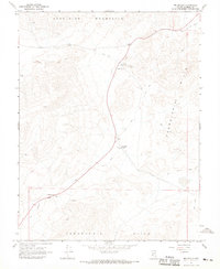
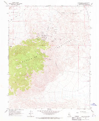
 1967 Mina1970 Print · USGSMineral County, Nevada, centers on the rail stop of Mina in the late sixties. Genealogists and historians can trace the town's footprint from Mina Cemetery to the industrial legacy of the Nun Mine and the Old Railroad Grade.2 unique versions available
Showing maps 1-25 of 29
Top cities of Mineral County
Frequently asked questions
- What are the different types of historical maps available for Mineral County?
- What is the oldest map of Mineral County?
- Where can I purchase historical maps of Mineral County for my home or office?
- Where can I download high-res historical maps of Mineral County?
- Are there historical topographic maps available for Mineral County?
- Is there historical aerial imagery available for Mineral County?
- Where are historical maps of Mineral County sourced from?