1940s Maps of White Pine County, Nevada
Explore 3 historic maps of White Pine County from the 1940s. These maps offer a rare glimpse into what life looked like during the 1940s — showing old roads, neighborhoods, homes, and landmarks that have changed or disappeared over time.
Whether you're researching your family's past, planning a metal detecting trip, or studying how White Pine County's landscape evolved across the 1940s, these high-resolution maps are a powerful tool for exploring the history of this region.
- Focus on a specific era: All maps on this page are from the 1940s, giving you a focused view of this time period.
- See what’s changed: Compare century-old streets, trails, and buildings to today's modern landscape using overlays and satellite layers.
- Research with precision: Use these maps for genealogy, historical research, land use analysis, or educational projects.
- View, download, or print: Maps are fully viewable online in high resolution, and can be downloaded or printed for your own records.
Start exploring White Pine County's history through authentic maps from the 1940s. This is your window into the past.
White Pine County, NV maps
(3)- 1948 Map of Wheeler Peak, 1961 Print
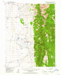 1948 Wheeler Peak1961 Print · USGSThe Snake Range and high desert flats of White Pine County come into focus shortly after the war, showing a landscape shaped by high-altitude mining and ranching. Researchers can trace historic family holdings like Yelton Ranch and locate remote operations including the Silver Bell Mine and Hub Mine.2 unique versions available
 - 1949 Map of Garrison, 1957 Print
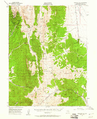
 1949 Garrison1957 Print · USGSThe high desert border of White Pine County and Utah’s Millard County comes into focus in the late 1940s as a land of isolated ranches and mountain peaks. Genealogists and historians can locate family landmarks like Davies Ranch and Burbank Cem or trace the early paths to Lehman Caves National Monument.4 unique versions available
 - 1949 Map of Treasure Hill, 1960 Print
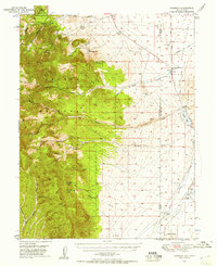
 1949 Treasure Hill1960 Print · USGSMining operations and remote desert outposts define the White Pine landscape in the late 1940s. Genealogists and historians can trace the legacy of the silver boom through sites like Eberhardt, the Hidden Treasure Mine, and Ellison Ranger Station.2 unique versions available
End of results
Showing maps 1-3 of 3
Top cities of White Pine County
Frequently asked questions
- What are the different types of historical maps available for White Pine County?
- What is the oldest map of White Pine County?
- Where can I purchase historical maps of White Pine County for my home or office?
- Where can I download high-res historical maps of White Pine County?
- Are there historical topographic maps available for White Pine County?
- Is there historical aerial imagery available for White Pine County?
- Where are historical maps of White Pine County sourced from?