1940s Maps of Carroll County, New Hampshire
Explore 8 historic maps of Carroll County from the 1940s. These maps offer a rare glimpse into what life looked like during the 1940s — showing old roads, neighborhoods, homes, and landmarks that have changed or disappeared over time.
Whether you're researching your family's past, planning a metal detecting trip, or studying how Carroll County's landscape evolved across the 1940s, these high-resolution maps are a powerful tool for exploring the history of this region.
- Focus on a specific era: All maps on this page are from the 1940s, giving you a focused view of this time period.
- See what’s changed: Compare century-old streets, trails, and buildings to today's modern landscape using overlays and satellite layers.
- Research with precision: Use these maps for genealogy, historical research, land use analysis, or educational projects.
- View, download, or print: Maps are fully viewable online in high resolution, and can be downloaded or printed for your own records.
Start exploring Carroll County's history through authentic maps from the 1940s. This is your window into the past.
Carroll County, NH maps
(8)- 1941 Map of Fryeburg
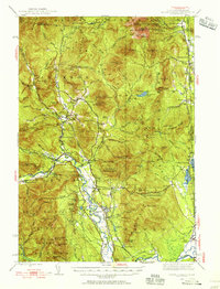
 1941 Fryeburg1941 Print · USGSOxford County and the Maine-New Hampshire borderlands are captured here just before the war, showcasing a landscape of isolated hills and interconnected lakes. Genealogists can locate family-named landmarks like Mc Daniels Hill and numerous rural schools including Plummer Sch and Black Mountain Sch.
 - 1942 Map of Gorham
 1942 Gorham1942 Print · USGSIn the early 1940s, the high peaks of the New Hampshire border region were already a hub for hikers and rail travel. Trace the historical routes of the Appalachian Trail and find landmarks like the Mascot Mine, the Glen House, and the Grand Trunk railroad.3 unique versions available
 - 1942 Map of North Conway, 1956 Print
 1942 North Conway1956 Print · USGSThe Saco River valley at the onset of the 1940s shows a landscape balancing timber heritage with growing mountain tourism. Researchers can trace historic rail lines like the Maine Central RR, locate the Eastman Sch, or find early wilderness outposts like the Black Mtn Cabin.4 unique versions available
 - 1942 Map of Newfield, 1959 Print
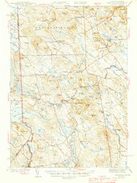
 1942 Newfield1959 Print · USGSThe Maine and New Hampshire borderlands come to life in the early 1940s, showing a network of mill towns and mountain peaks. Researchers can trace family lines through small settlements like South Parsonsfield, locate the Spinney Ch, or explore the shores of Great East Lake and Mousam Lake.
 - 1944 Map of Newfield
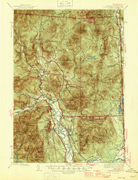
 1944 Newfield1944 Print · USGSYork County and the New Hampshire borderlands are captured here during the mid-1940s, showing a landscape of mill towns and interconnected lakes. Genealogists and historians can trace family-named sites like Dearborn Mtn and Stevens Cor or explore the early layouts of Limerick and Milton Mills.2 unique versions available
 - 1945 Map of North Conway
 1945 North Conway1945 Print · USGSThe Mount Washington Valley comes alive in the mid-1940s, showing the early infrastructure of the White Mountains' famous resort villages. Genealogists and historians can locate family landmarks like the Eastman Sch, the Panno Place, and the rail junction at Intervale.3 unique versions available
 - 1946 Map of Crawford Notch, 1955 Print
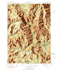 1946 Crawford Notch1955 Print · USGSThe White Mountains in the mid-1940s reveal a network of historic rail corridors and backcountry shelters. Trace the Maine Central Railroad through the notch or locate early landmarks like Crawford House and the Willey House P.O.9 unique versions available
 - 1949 Map of Portland
 1949 Portland1949 Print · USGSCoastal Maine and the New Hampshire interior are shown in detail during the late forties, from the bustling harbors to the lakeside villages. Researchers can trace historical rail networks like the Boston & Maine RR and locate coastal defenses such as Fort Preble.3 unique versions available
End of results
Showing maps 1-8 of 8
Top cities of Carroll County
- Wakefield historical maps
- Moultonborough historical maps
- Ossipee historical maps
- Conway historical maps
- Wolfeboro historical maps
- Bartlett historical maps
See more
Frequently asked questions
- What are the different types of historical maps available for Carroll County?
- What is the oldest map of Carroll County?
- Where can I purchase historical maps of Carroll County for my home or office?
- Where can I download high-res historical maps of Carroll County?
- Are there historical topographic maps available for Carroll County?
- Is there historical aerial imagery available for Carroll County?
- Where are historical maps of Carroll County sourced from?