1930s Maps of Carroll County, New Hampshire
Explore 6 historic maps of Carroll County from the 1930s. These maps offer a rare glimpse into what life looked like during the 1930s — showing old roads, neighborhoods, homes, and landmarks that have changed or disappeared over time.
Whether you're researching your family's past, planning a metal detecting trip, or studying how Carroll County's landscape evolved across the 1930s, these high-resolution maps are a powerful tool for exploring the history of this region.
- Focus on a specific era: All maps on this page are from the 1930s, giving you a focused view of this time period.
- See what’s changed: Compare century-old streets, trails, and buildings to today's modern landscape using overlays and satellite layers.
- Research with precision: Use these maps for genealogy, historical research, land use analysis, or educational projects.
- View, download, or print: Maps are fully viewable online in high resolution, and can be downloaded or printed for your own records.
Start exploring Carroll County's history through authentic maps from the 1930s. This is your window into the past.
Carroll County, NH maps
(6)- 1930 Map of Ossipee Lake
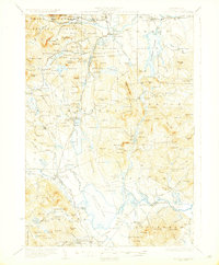 1930 Ossipee Lake1930 Print · USGSCarroll County at the dawn of the 1930s shows a landscape of lakeside villages and mountain resorts connected by the Boston and Maine Railroad. Genealogy researchers can trace family sites like the Albany Cem, Mountain Ch, or old schoolhouses like the Nickerson Sch.8 unique versions available
 - 1931 Map of Plymouth
 1931 Plymouth1931 Print · USGSGrafton County communities are linked by the Boston and Maine Railroad during the early thirties. Genealogists can trace family roots through numerous rural landmarks like Thornton Center, Blair Sch, and the riverside landings at Livermore Falls.5 unique versions available
 - 1931 Map of Mt. Chocorua
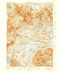 1931 Mt. Chocorua1931 Print · USGSCarroll County’s timber and mountain landscape is captured here in the late Prohibition era. Researchers can trace the path of the Beebe River RR, locate old schoolhouses like Fellows Sch, and find family sites near Wonalancet or Center Sandwich.7 unique versions available
 - 1933 Map of Newfield
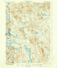
 1933 Newfield1933 Print · USGSThe Maine-New Hampshire borderlands in the early 1930s are captured here as a series of connected lakeside settlements. Trace family roots and old property lines near Milton Mills, Spinney Church, and the shores of Great East Lake.
 - 1937 Map of Newfield
 1937 Newfield1937 Print · USGSThe Maine and New Hampshire borderlands are captured here during the late 1930s, showing a landscape defined by riverside villages and glacial lakes. Genealogists and historians can trace family locations near Ossipee Mills, Spuney Ch, and the many hamlets of Parsonsfield.3 unique versions available
 - 1937 Map of Gorham
 1937 Gorham1937 Print · USGSNew Hampshire's high peaks and river valleys are shown in detail during the late 1930s as the regional economy balanced rail industry with forest conservation. Genealogists and hikers can trace the Appalachian Trail, locate Civilian Conservation Corps sites like CCC Camp Gorham, and study the industrial corridors of the Grand Trunk Railway.6 unique versions available
End of results
Showing maps 1-6 of 6
Top cities of Carroll County
- Wakefield historical maps
- Moultonborough historical maps
- Ossipee historical maps
- Conway historical maps
- Wolfeboro historical maps
- Bartlett historical maps
See more
Frequently asked questions
- What are the different types of historical maps available for Carroll County?
- What is the oldest map of Carroll County?
- Where can I purchase historical maps of Carroll County for my home or office?
- Where can I download high-res historical maps of Carroll County?
- Are there historical topographic maps available for Carroll County?
- Is there historical aerial imagery available for Carroll County?
- Where are historical maps of Carroll County sourced from?