2000-2009 Maps of Carroll County, New Hampshire
Explore 3 historic maps of Carroll County from 2000-2009. These maps offer a rare glimpse into what life looked like during the 2000s — showing old roads, neighborhoods, homes, and landmarks that have changed or disappeared over time.
Whether you're researching your family's past, planning a metal detecting trip, or studying how Carroll County's landscape evolved across the 2000s, these high-resolution maps are a powerful tool for exploring the history of this region.
- Focus on a specific era: All maps on this page are from the 2000s, giving you a focused view of this time period.
- See what’s changed: Compare century-old streets, trails, and buildings to today's modern landscape using overlays and satellite layers.
- Research with precision: Use these maps for genealogy, historical research, land use analysis, or educational projects.
- View, download, or print: Maps are fully viewable online in high resolution, and can be downloaded or printed for your own records.
Start exploring Carroll County's history through authentic maps from the 2000s. This is your window into the past.
Carroll County, NH maps
(3)- 2000 Map of Tuftonboro, 2001 Print
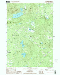 2000 Tuftonboro2001 Print · USGSThe lakeside communities and mountain foothills of Carroll County are captured here at the turn of the millennium. Genealogists and local historians can locate early homestead sites near Water Village, Chickville, and the historic Stockbridge Corner.
 - 2000 Map of Farmington, 2001 Print
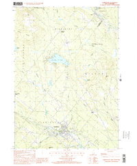 2000 Farmington2001 Print · USGSThe Strafford County highlands around Farmington at the end of the century reveal a landscape of river valleys and ridgelines. Trace the Old Railroad Grade past Sunrise Lake or locate old homesteads near Middleton Corners and Hayes Corner.
 - 2000 Map of Sanbornville, 2001 Print
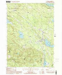 2000 Sanbornville2001 Print · USGSThe eastern Carroll County highlands at the turn of the millennium show a landscape of historic rail stations and protected forests. Trace local heritage at Cotton Valley Station, the Governor Wentworth State Farm, and the slopes of the Moose Mountains.
End of results
Showing maps 1-3 of 3
Top cities of Carroll County
- Wakefield historical maps
- Moultonborough historical maps
- Ossipee historical maps
- Conway historical maps
- Wolfeboro historical maps
- Bartlett historical maps
See more
Frequently asked questions
- What are the different types of historical maps available for Carroll County?
- What is the oldest map of Carroll County?
- Where can I purchase historical maps of Carroll County for my home or office?
- Where can I download high-res historical maps of Carroll County?
- Are there historical topographic maps available for Carroll County?
- Is there historical aerial imagery available for Carroll County?
- Where are historical maps of Carroll County sourced from?