1990s Maps of Carroll County, New Hampshire
Explore 21 historic maps of Carroll County from the 1990s. These maps offer a rare glimpse into what life looked like during the 1990s — showing old roads, neighborhoods, homes, and landmarks that have changed or disappeared over time.
Whether you're researching your family's past, planning a metal detecting trip, or studying how Carroll County's landscape evolved across the 1990s, these high-resolution maps are a powerful tool for exploring the history of this region.
- Focus on a specific era: All maps on this page are from the 1990s, giving you a focused view of this time period.
- See what’s changed: Compare century-old streets, trails, and buildings to today's modern landscape using overlays and satellite layers.
- Research with precision: Use these maps for genealogy, historical research, land use analysis, or educational projects.
- View, download, or print: Maps are fully viewable online in high resolution, and can be downloaded or printed for your own records.
Start exploring Carroll County's history through authentic maps from the 1990s. This is your window into the past.
Carroll County, NH maps
(21)- 1995 Map of Great East Lake, 1999 Print
 1995 Great East Lake1999 Print · USGSThe Maine and New Hampshire borderlands are captured here in the mid-nineties, showing a landscape of interconnected lakes and small mill towns. Local historians can trace family-named sites like McCutcheon Corners, rural landmarks like Maple Grove Ch, and the course of the Salmon Falls River.
 - 1995 Map of Stairs Mountain, 2000 Print
 1995 Stairs Mountain2000 Print · USGSThe White Mountains in the mid-nineties show a landscape of steep peaks and historic land grants. Hikers and historians can trace the paths of Sargents Purchase and locate high-altitude landmarks like Mizpah Spring Hut and Willey House PO.
 - 1995 Map of Jackson, 2000 Print
 1995 Jackson2000 Print · USGSJackson and the surrounding White Mountains are captured here in the mid-nineties, showing the village just as the Wildcat Brook was designated a Wild and Scenic River. Hikers and historians can trace the Appalachian Trail, locate the historic Covered Bridge, and find remote landmarks like Doublehead Cabin and Perkins Notch Shelter.
 - 1995 Map of North Conway East, 2000 Print
 1995 North Conway East2000 Print · USGSThe eastern White Mountains meet the Maine border in the 1990s, centering on the outdoor-recreation hub of North Conway. Local historians can trace the Conway Scenic Railway, explore the footpaths of the Weeks Brook Trail, or locate landmarks like Redstone Ledge and Mineral Spring.
 - 1995 Map of Bartlett, 2000 Print
 1995 Bartlett2000 Print · USGSThe Saco River valley and its mountain peaks are documented here in the mid-1990s as a hub of forestry and recreation. Researchers can trace the layout of Bartlett, locate the Cem, and follow early access routes like Notch Road and the Parker Trail.
 - 1995 Map of Mount Carrigain, 2000 Print
 1995 Mount Carrigain2000 Print · USGSThe high peaks of the White Mountains are shown here in the 1990s, when conservation and trail networks defined the region. Hikers and historians can trace the route over Kancamagus Pass or locate remote landmarks like Stillwater and Signal Ridge.
 - 1995 Map of Mount Tripyramid, 2000 Print
 1995 Mount Tripyramid2000 Print · USGSThe high peaks and deep valleys of the White Mountains are captured here in the mid-nineties, showing the vast recreational network of the Sandwich Range. Trace the paths of early hikers and foresters through Livermore Pass, or locate remote landmarks like Flat Pond Shelter and Sabbaday Falls.
 - 1995 Map of Silver Lake, 2000 Print
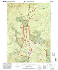
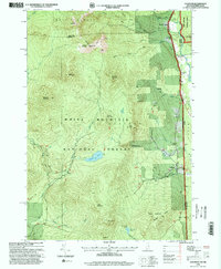
 1995 Silver Lake2000 Print · USGSCarroll County in the mid-nineties shows a landscape of granite peaks and glacial lakes transitioning into the railroad settlements of the eastern valleys. Researchers can trace the Conway Branch Railroad through Madison and Silver Lake (Madison Sta) or locate the massive Madison Boulder State Geologic Site.
 - 1995 Map of Waterville Valley, 2000 Print
 1995 Waterville Valley2000 Print · USGSWaterville Valley and the surrounding peaks of the White Mountain National Forest are captured in the mid-1990s as a hub of both recreation and wilderness. Genealogists and hikers can trace the paths between the Mad River Cemetery, Goose Hollow, and the remote Greeley Pond.
 - 1995 Map of Wild River, 2000 Print
 1995 Wild River2000 Print · USGSThe White Mountains come alive in the 1990s as this map traces the intricate trail networks and wilderness reaches across the New Hampshire and Maine state line. Researchers can locate remote landmarks like the Brickett Place or trace the Appalachian Trail as it passes Middle Moriah Mountain.
 - 1995 Map of North Conway West, 2000 Print
 1995 North Conway West2000 Print · USGSThe Saco River valley during the mid-nineties shows a landscape where historic settlements and burgeoning recreation meet. Researchers can trace the path of the CONWAY SCENIC RAILROAD or locate local landmarks like the Covered Bridge and the village of Intervale.
 - 1995 Map of Crawford Notch, 2000 Print
 1995 Crawford Notch2000 Print · USGSGrafton and Carroll Counties are shown here during the mid-nineties, capturing the extensive trail systems and wilderness boundaries of the White Mountains. Hikers and historians can trace the Appalachian National Scenic Trail past Zealand Falls or locate the historic Willey House (Site).
 - 1995 Map of Center Sandwich, 2000 Print
 1995 Center Sandwich2000 Print · USGSThe Sandwich and Moultonborough area is shown here in the mid-1990s, where the White Mountains meet the northern shores of Squam Lake. Genealogists and historians can trace local homesteads and landmarks like Chicks Corner, Diamond Ledge, and the old cemeteries near Center Sandwich.
 - 1995 Map of Mount Chocorua, 2000 Print
 1995 Mount Chocorua2000 Print · USGSIn the mid-nineties, the rugged heart of the White Mountains was a landscape of dense wilderness trails and quiet valley hamlets. Local historians can trace early routes like the Old Mast Road Trail or locate family sites near Wonalancet and Passaconaway.
 - 1995 Map of Squam Mountains, 2000 Print
 1995 Squam Mountains2000 Print · USGSThe Squam Mountains and northern lakeshore are captured here in the mid-1990s as hiking trails and summer colonies matured. Researchers can trace the Sandwich Notch Road, find the lakeside Rockywold settlement, and locate the historic Covered Bridge over the Beebe River.
 - 1995 Map of Chatham, 2000 Print
 1995 Chatham2000 Print · USGSChatham and the White Mountain high country are captured here in the mid-1990s as a haven for hikers and remote settlers. Researchers can trace the trails and summits of Sable Mountain or locate the Cold River AMC Camp and local cemeteries.
 - 1998 Map of Center Harbor, 1999 Print
 1998 Center Harbor1999 Print · USGSThe New Hampshire Lakes Region is captured in detail in the late nineties, showing the complex shorelines and islands of the northern reaches. Researchers can trace the development of Center Harbor and Meredith or locate specific island landmarks like Bear Island and Black Cat Island.
 - 1998 Map of Ossipee, 1999 Print
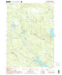 1998 Ossipee1999 Print · USGSThe rural landscapes of Carroll County are captured here in the late nineties, documenting a network of small settlements and conservation forests. Researchers can locate specific family landmarks and local businesses like Chases Mill, the Drive-in Theater, and Leighton Corners.
 - 1998 Map of Ossipee Lake, 2001 Print
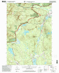
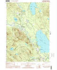 1998 Ossipee Lake2001 Print · USGSThe Carroll County lake region is captured here in the late nineties, documenting a landscape of mountain peaks and lowland waters. Genealogists and historians can locate old stations at West Ossipee or trace family sites near Moultonville and Dorrs Corner.
 - 1998 Map of Conway, 2001 Print
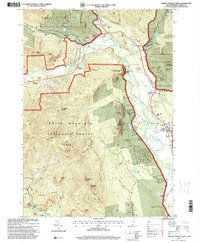
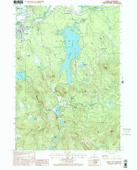 1998 Conway2001 Print · USGSCarroll County’s landscape is captured here at the end of the century, showing the established communities of Conway and Center Conway during a period of steady growth. Researchers can trace local landmarks from Conway Lake to smaller hamlets like Snowville and Eaton Center.
 - 1998 Map of Tamworth, 2001 Print
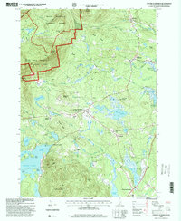
 1998 Tamworth2001 Print · USGSThe Carroll County highlands at the end of the twentieth century show a landscape shaped by the Bearcamp River and the high peaks of the Ossipee Mountains. Genealogists and hikers can locate old settlements like South Tamworth and Whittier or trace the drainage of Cold Brook through the state forests.
End of results
Showing maps 1-21 of 21
Top cities of Carroll County
- Wakefield historical maps
- Moultonborough historical maps
- Ossipee historical maps
- Conway historical maps
- Wolfeboro historical maps
- Bartlett historical maps
See more
Frequently asked questions
- What are the different types of historical maps available for Carroll County?
- What is the oldest map of Carroll County?
- Where can I purchase historical maps of Carroll County for my home or office?
- Where can I download high-res historical maps of Carroll County?
- Are there historical topographic maps available for Carroll County?
- Is there historical aerial imagery available for Carroll County?
- Where are historical maps of Carroll County sourced from?