1950s Maps of Cheshire County, New Hampshire
Explore 17 historic maps of Cheshire County from the 1950s. These maps offer a rare glimpse into what life looked like during the 1950s — showing old roads, neighborhoods, homes, and landmarks that have changed or disappeared over time.
Whether you're researching your family's past, planning a metal detecting trip, or studying how Cheshire County's landscape evolved across the 1950s, these high-resolution maps are a powerful tool for exploring the history of this region.
- Focus on a specific era: All maps on this page are from the 1950s, giving you a focused view of this time period.
- See what’s changed: Compare century-old streets, trails, and buildings to today's modern landscape using overlays and satellite layers.
- Research with precision: Use these maps for genealogy, historical research, land use analysis, or educational projects.
- View, download, or print: Maps are fully viewable online in high resolution, and can be downloaded or printed for your own records.
Start exploring Cheshire County's history through authentic maps from the 1950s. This is your window into the past.
Cheshire County, NH maps
(17)- 1950 Map of Glens Falls
 1950 Glens Falls1950 Print · USGSThe Adirondacks and the Green Mountains meet in this mid-century survey of the New York and Vermont borderlands. Researchers can trace the industrial rail corridors of the Rutland RR and Delaware & Hudson RR connecting Glens Falls, Rutland, and the shores of Lake George.
 - 1950 Map of Ashburnham, 1952 Print
 1950 Ashburnham1952 Print · USGSMid-century Worcester County comes to life as a landscape of interconnected glacial lakes and upland ridges during the postwar years. Genealogists and local historians can trace the foundations of Ashburnham, Lane Village, and the remote Old North Ashburnham Sta.4 unique versions available
 - 1953 Map of Fitchburg
 1953 Fitchburg1953 Print · USGSMid-century Worcester County comes to life during a period of steady growth and established rail commerce. Local historians can trace family roots at Prospect Hill Cemetery or explore the development of Blackburne Village and the Fitchburg Leominster Airport.
 - 1953 Map of Peterborough, 1956 Print
 1953 Peterborough1956 Print · USGSHillsborough County in the mid-fifties is captured here as a region of mill towns and mountain trails during a period of steady growth. Researchers can locate family landmarks like the Edward MacDowell Grave, trace the Boston and Maine Railroad, or find old school sites like Appleton Academy.3 unique versions available
 - 1954 Map of Winchendon, 1955 Print
 1954 Winchendon1955 Print · USGSNorthwestern Worcester County comes to life in the mid-1950s, showing a landscape defined by mill ponds and early manufacturing hamlets. Trace family roots at Riverside Cem or locate the sites of Harrisville, Bullardville, and the Woodcock Sch.3 unique versions available
 - 1954 Map of Royalston, 1955 Print
 1954 Royalston1955 Print · USGSThe Worcester County highlands and the New Hampshire border are documented here in the mid-fifties as the railroad era transitioned into the age of modern state highways. Researchers can trace ancestral locations near the Raymond Sch, follow the path of the Boston and Maine Railroad, or locate landmarks like Doane Falls.3 unique versions available
 - 1954 Map of Brattleboro, 1956 Print
 1954 Brattleboro1956 Print · USGSThe Connecticut River valley thrives in the mid-1950s as a bustling rail and educational hub connecting Vermont and New Hampshire. Genealogists and historians can trace family-named burial grounds like Houghton Cem and Wilkens Hill Cem, or locate landmarks like Windham College and Retreat Meadows.4 unique versions available
 - 1956 Map of Boston, 1967 Print
 1956 Boston1967 Print · USGSThe Massachusetts coastline and industrial interior are seen here during the mid-century peak of suburban and highway expansion. Researchers can trace historic harbor defenses like Fort Revere, local landmarks such as Faneuil Hall, and the vast Parker River National Wildlife Refuge.6 unique versions available
 - 1956 Map of Albany, 1968 Print
 1956 Albany1968 Print · USGSThe industrial heart of the Northeast is revealed in the mid-1950s, from the Hudson Valley to the Connecticut River. Researchers can trace the legacy of the Quabbin Reservoir, locate Westover Air Force Base, or follow the Rutland RR through the Green Mountains.2 unique versions available
 - 1956 Map of Glens Falls, 1968 Print
 1956 Glens Falls1968 Print · USGSUpper New York and the Vermont mountains are captured here in the mid-fifties, showing the rugged rail-and-river network of the Northeast. Researchers can trace the paths of the Delaware and Hudson RR and Rutland RR as they wind through valley towns like Poultney and Whitehall.3 unique versions available
 - 1957 Map of Albany
 1957 Albany1957 Print · USGSThe Tri-State region and Connecticut River Valley are captured here during a period of significant postwar growth and infrastructure expansion. Genealogists and historians can trace the rail-and-river economy through landmarks like the Boston and Maine railroad, Quabbin Reservoir, and Westover Air Force Base.
 - 1957 Map of Lovewell Mountain, 1959 Print
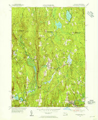
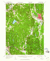
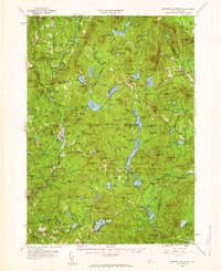 1957 Lovewell Mountain1959 Print · USGSThe hill country of southwestern New Hampshire is captured here in the mid-1950s, showing the intersection of Sullivan, Cheshire, and Hillsborough counties. Researchers can trace old routes like the Dartmouth College Highway and locate rural landmarks such as Advent Ch, Mill Village, and East Lempster.4 unique versions available
 - 1957 Map of Bellows Falls, 1960 Print
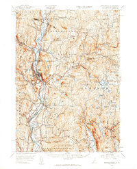 1957 Bellows Falls1960 Print · USGSThe Connecticut River valley and its border communities were defined by industry and rail at mid-century. Genealogists and historians can trace the paths of the Boston and Maine railroad, locate the Kurn Hattin Home, or find the historic Dodge Tavern.4 unique versions available
 - 1958 Map of Boston
 1958 Boston1958 Print · USGSEastern Massachusetts and southern New Hampshire are shown at the height of the industrial era, before the full expansion of the interstate system. Trace coastal defenses at Fort Warren, historic rail lines like the Boston and Maine, and the development of the Mass. 128 corridor.2 unique versions available
 - 1958 Map of Keene, 1960 Print
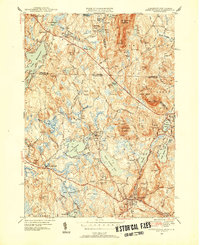
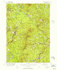
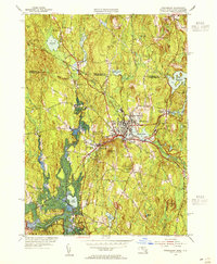
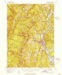
 1958 Keene1960 Print · USGSCheshire County centers on Keene during the mid-twentieth century, showing a landscape shaped by the Ashuelot River and rail industry. Genealogists and historians can locate rural landmarks like Mt Caesar Sch, the rail junction at Dole Junction, and old family-named sites from Westmoreland to Richmond.3 unique versions available
 - 1959 Map of Glens Falls
 1959 Glens Falls1959 Print · USGSUpper New York and Vermont are captured here during the late 1950s, a period of transition for these mountain communities. Researchers can trace the legacy of the region's river-and-rail economy through landmarks like Lake George, Saratoga Springs, and Killington Peak.2 unique versions available
 - 1959 Map of Albany
 1959 Albany1959 Print · USGSThe Hudson and Connecticut River valleys are captured here during the late fifties, showing the region's dense rail networks and massive water projects. Researchers can trace the New York State Thruway or locate local landmarks like Mt Greylock and the Quabbin Reservoir.
End of results
Showing maps 1-17 of 17
Top cities of Cheshire County
- Keene historical maps
- Swanzey historical maps
- Rindge historical maps
- Winchester historical maps
- Walpole historical maps
- Chesterfield historical maps
See more
Frequently asked questions
- What are the different types of historical maps available for Cheshire County?
- What is the oldest map of Cheshire County?
- Where can I purchase historical maps of Cheshire County for my home or office?
- Where can I download high-res historical maps of Cheshire County?
- Are there historical topographic maps available for Cheshire County?
- Is there historical aerial imagery available for Cheshire County?
- Where are historical maps of Cheshire County sourced from?