1990s Maps of Cheshire County, New Hampshire
Explore 19 historic maps of Cheshire County from the 1990s. These maps offer a rare glimpse into what life looked like during the 1990s — showing old roads, neighborhoods, homes, and landmarks that have changed or disappeared over time.
Whether you're researching your family's past, planning a metal detecting trip, or studying how Cheshire County's landscape evolved across the 1990s, these high-resolution maps are a powerful tool for exploring the history of this region.
- Focus on a specific era: All maps on this page are from the 1990s, giving you a focused view of this time period.
- See what’s changed: Compare century-old streets, trails, and buildings to today's modern landscape using overlays and satellite layers.
- Research with precision: Use these maps for genealogy, historical research, land use analysis, or educational projects.
- View, download, or print: Maps are fully viewable online in high resolution, and can be downloaded or printed for your own records.
Start exploring Cheshire County's history through authentic maps from the 1990s. This is your window into the past.
Cheshire County, NH maps
(19)- 1990 Map of Northfield
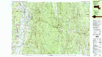 1990 Northfield1990 Print · USGSThe tri-state border of Massachusetts, New Hampshire, and Vermont comes into focus in the 1990s as a landscape of river valleys and forested peaks. Researchers can trace the grounds of the Northfield Mt Hermon School or locate old burial sites like South Parish Cem and Center Cem.2 unique versions available
 - 1997 Map of Peterborough North, 1998 Print
 1997 Peterborough North1998 Print · USGSHillsborough County in the late nineties is a landscape of artist colonies and river-powered hamlets centered on the Contoccook River. Researchers can locate family landmarks such as the St Joseph Minor Seminary Cem or explore the grounds of the historic MacDowell Colony.
 - 1997 Map of Peterborough South, 1998 Print
 1997 Peterborough South1998 Print · USGSHillsborough County's highland forests and river valleys are captured here in the late 1990s, highlighting a landscape defined by conservation and topography. Researchers can trace the Wapack Trail over Barrett Mountain or locate historical settlements like Noone and Squantum.
 - 1998 Map of Marlborough, 2002 Print
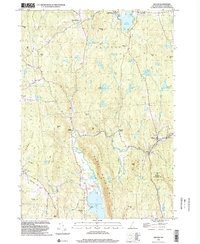
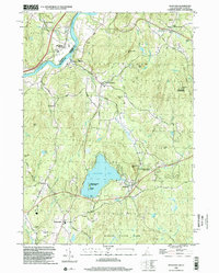
 1998 Marlborough2002 Print · USGSCheshire County at the close of the millennium shows a landscape of small mill villages and dense forests. Genealogists can trace family sites at Meetinghouse Cem or Pine Grove Cem and locate landmarks from the County Fairground to Harrisville.
 - 1998 Map of Marlow, 2002 Print
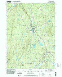
 1998 Marlow2002 Print · USGSCheshire County at the turn of the millennium shows a landscape of clustered villages and upland forests. Genealogists can locate family names at Jefts Cem and the Meetinghouse, while tracing old routes like Queen Street.
 - 1998 Map of Washington, 2002 Print
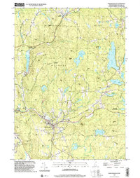
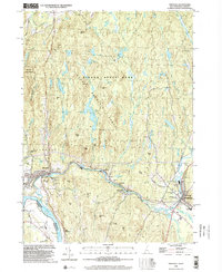
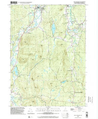
 1998 Washington2002 Print · USGSSullivan County at the close of the twentieth century remains a landscape of deep woods and interconnected glacial ponds. Genealogists and hikers can trace the village layout of Washington or locate historic landmarks like Bradford Spring and the Center Sch.
 - 1998 Map of East Lempster, 2002 Print
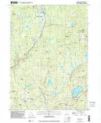
 1998 East Lempster2002 Print · USGSThe highland forests and millponds of Sullivan and Cheshire counties are captured here in the late nineties. Local researchers can trace the roads to Marlow Junction, locate the Perkins Sch, and follow the Monadnock-Sunapee Trail through the hills.
 - 1998 Map of Keene, 2002 Print
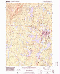
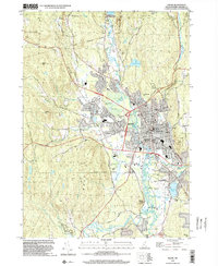 1998 Keene2002 Print · USGSKeene and the Ashuelot River valley are shown in the late twentieth century as the city expanded southward toward the airport. Genealogists can locate family sites at Monadnock View Cem or trace local landmarks like the Covered Bridge and the Daniels Sch.
 - 1998 Map of Gilsum, 2002 Print
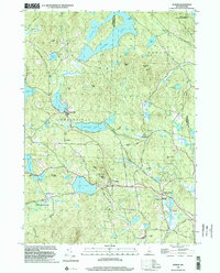
 1998 Gilsum2002 Print · USGSCheshire County at the end of the twentieth century shows a landscape defined by the Ashuelot River valley and rocky New Hampshire uplands. Genealogists and historians can locate family landmarks like Slade Cem, the small hamlet of Lower Village, and the remote Mine Ledge.
 - 1998 Map of Hinsdale, 2002 Print
 1998 Hinsdale2002 Print · USGSThe Ashuelot River valley and the Pisgah Mountain Range define this southwestern New Hampshire landscape at the close of the twentieth century. Researchers can trace the Vermont Central RR line near Hinsdale or locate landmarks like St Josephs Ch and Meetinghouse Hill.
 - 1998 Map of Dublin, 2002 Print
 1998 Dublin2002 Print · USGSCheshire County’s highland terrain and glacial ponds appear in detailed relief during the late 1990s. Researchers can trace the Old Railroad Grade past Harrisville, find the Dublin Spire, or locate old routes like Goldmine Road.
 - 1998 Map of Walpole, 2002 Print
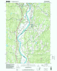 1998 Walpole2002 Print · USGSThe Connecticut River valley at the close of the twentieth century shows a mature landscape of hill-country farming and river-town industry. Genealogists and local researchers can trace family landmarks like Dodge Tavern or explore the grounds of the Kurn Hattin Sch and St Peters Cem.
 - 1998 Map of Troy, 2002 Print
 1998 Troy2002 Print · USGSCheshire County at the end of the millennium shows a landscape defined by state forests and historic rail corridors. Researchers can trace the Old Railroad Grade past Fitzwilliam Depot or locate landmarks like the Emerson Sch.
 - 1998 Map of Spofford, 2002 Print
 1998 Spofford2002 Print · USGSCheshire County at the close of the twentieth century shows a landscape of protected state parks and historic river towns. Genealogists and hikers can trace connections between Chesterfield, Poocham, and Westmoreland while finding landmarks like Pioneer Sch and Spofford Lake.
 - 1998 Map of Stoddard, 2002 Print
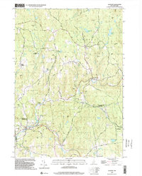
 1998 Stoddard2002 Print · USGSNew Hampshire's high country near the turn of the millennium shows a landscape shaped by glacial ponds and granite peaks. Genealogists and hikers can trace the Monadnock-Sunapee Trail through old settlements like Mill Village and Loverens Mill.
 - 1998 Map of Monadnock Mountain, 2002 Print
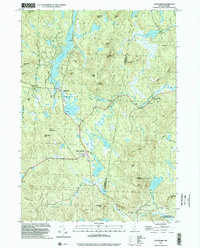
 1998 Monadnock Mountain2002 Print · USGSCheshire County at the close of the millennium shows a landscape of outdoor recreation and collegiate growth. Genealogists and hikers can trace paths to Cutler Cem or follow the Monadnock-Sunapee Trail through Monadnock State Park.
 - 1998 Map of Bellows Falls, 2002 Print
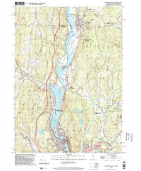 1998 Bellows Falls2002 Print · USGSThe borderlands of Vermont and New Hampshire come alive in the 1990s as the river economy transitions toward modern infrastructure. Trace family names and landmarks from Bellows Falls to Charlestown, finding sites like Bates Mill Pond and the Mt Kilburn Tower.
 - 1998 Map of Alstead, 2002 Print
 1998 Alstead2002 Print · USGSSullivan and Cheshire Counties appear at the end of the twentieth century, showing a landscape of upland forests and river valleys. Genealogists and hikers can trace the winding Old Settlers Road, locate the Covered Bridge near Langdon, or find family landmarks like Forristalls Corner.
 - 1998 Map of West Swanzey, 2002 Print
 1998 West Swanzey2002 Print · USGSSwanzey and Richmond are shown in the late 1990s as the New Hampshire landscape balances residential growth with large conservation tracts. Trace local genealogy and landmarks through Mt Caesar Cem, the Cutler Sch, and the shoreline of Swanzey Lake.
End of results
Showing maps 1-19 of 19
Top cities of Cheshire County
- Keene historical maps
- Swanzey historical maps
- Rindge historical maps
- Winchester historical maps
- Walpole historical maps
- Chesterfield historical maps
See more
Frequently asked questions
- What are the different types of historical maps available for Cheshire County?
- What is the oldest map of Cheshire County?
- Where can I purchase historical maps of Cheshire County for my home or office?
- Where can I download high-res historical maps of Cheshire County?
- Are there historical topographic maps available for Cheshire County?
- Is there historical aerial imagery available for Cheshire County?
- Where are historical maps of Cheshire County sourced from?