1900s (20th Century) Maps of Delaware Township, New Jersey
Explore 26 historic maps of Delaware Township from the 1900s (20th Century). These maps offer a rare glimpse into what life looked like during the 1900s — showing old roads, neighborhoods, homes, and landmarks that have changed or disappeared over time.
Whether you're researching your family's past, planning a metal detecting trip, or studying how Delaware Township's landscape evolved across the 1900s, these high-resolution maps are a powerful tool for exploring the history of this region.
- Focus on a specific era: All maps on this page are from the 1900s, giving you a focused view of this time period.
- See what’s changed: Compare century-old streets, trails, and buildings to today's modern landscape using overlays and satellite layers.
- Research with precision: Use these maps for genealogy, historical research, land use analysis, or educational projects.
- View, download, or print: Maps are fully viewable online in high resolution, and can be downloaded or printed for your own records.
Start exploring Delaware Township's history through authentic maps from the 1900s. This is your window into the past.
Delaware Township, NJ maps
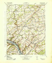
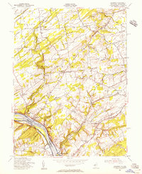
(26)- 1900 Map of Raritan
 1900 Raritan1900 Print · USGSNorth Jersey in the late nineteenth century was a complex web of mountain ridges and vital rail corridors. Researchers can trace ancestral routes through old junctions like High Bridge, industrial sites at Mine Hill, and the shores of Lake Hopatcong.
 - 1905 Map of Raritan
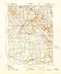
 1905 Raritan1905 Print · USGSNorthern New Jersey's ridges and valleys are meticulously detailed here at the turn of the century. You can trace the complex rail networks of the Lehigh Valley R.R. and locate family landmarks from Swayze Mills to the Powder Depot near Picatinny Peak.2 unique versions available
 - 1905 Map of High Bridge
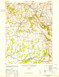
 1905 High Bridge1905 Print · USGSHunterdon County at the opening of the twentieth century was a vital junction for New Jersey’s industrial rail lines and river-powered settlements. Researchers can trace the legacy tracks of the Central Railroad of New Jersey and locate early communities like High Bridge, Clinton, and Annandale.4 unique versions available
 - 1906 Map of Lambertville
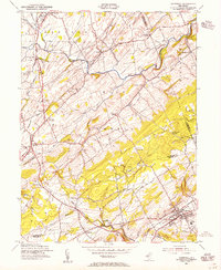
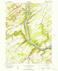
 1906 Lambertville1906 Print · USGSThe Delaware River valley in the early 1900s is shown in transition, where water-borne trade meets the expanding rail network. Genealogists and historians can trace family-named corners like Vanlieu Corners and Marshalls Corner alongside the Delaware and Raritan Canal.6 unique versions available
 - 1907 Map of Trenton
 1907 Trenton1907 Print · USGSThe Delaware River valley hums with turn-of-the-century industry and transport as river canals and railroads converge between New Jersey and Pennsylvania. Genealogists and local historians can trace the footprint of the George School, find early post offices like Holland PO, or locate old mill sites such as Blackwells Mills.4 unique versions available
 - 1942 Map of Norristown
 1942 Norristown1942 Print · USGSSoutheastern Pennsylvania at the onset of World War II shows a landscape of busy industrial river towns and expanding rail suburbs. Genealogists and historians can trace the early transit networks connecting Norristown, Doylestown, and the riverfront at New Hope.
 - 1943 Map of Stockton
 1943 Stockton1943 Print · USGSHunterdon and Bucks counties are captured here in the early 1940s, highlighting the vital river-and-rail corridor along the New Jersey-Pennsylvania border. Researchers can trace old schoolhouses like Locktown School or locate industrial sites like the Stone Quarry and Delaware Canal.2 unique versions available
 - 1943 Map of Point Pleasant
 1943 Point Pleasant1943 Print · USGSMid-century Bucks and Hunterdon counties come alive through this survey of the river valley during the war years. Researchers can trace the Canal Feeder and railroad lines that defined the Delaware River corridor, or locate family landmarks like the Menonite Cemetery and Reading School.
 - 1943 Map of Cakepoulin Creek
 1943 Cakepoulin Creek1943 Print · USGSHunterdon County during the early war years reveals a landscape of established rail corridors and rural hamlets. Local historians can trace family locations near the Lehigh Valley line, the Oakgrove Grange Hall, and country schools like Jutland School.
 - 1944 Map of Newark, 1971 Print
 1944 Newark1971 Print · USGSThe industrial corridor from Philadelphia to New York was in a period of massive transition during the mid-forties. Genealogists and researchers can trace the rail lines of the Lehigh Valley RR, locate military installations like Picatinny Arsenal, and explore the early sprawl near Levittown.5 unique versions available
 - 1949 Map of Newark
 1949 Newark1949 Print · USGSThe industrial corridor between Philadelphia and New York comes alive in this post-war survey. Genealogists and historians can trace the massive rail networks of the Reading Railroad and locate major installations like Fort Dix or Picatinny Arsenal.2 unique versions available
 - 1952 Map of Cakepoulin Creek
 1952 Cakepoulin Creek1952 Print · USGSHunterdon County during the early fifties shows a landscape of small farming hamlets and active rail corridors. Genealogists can trace family roots through landmarks like the Mt Salem Cemetery, Oakgrove Grange Hall, and Jutland School.2 unique versions available
 - 1954 Map of Hopewell, 1955 Print
 1954 Hopewell1955 Print · USGSMid-century New Jersey rural life is frozen in time here, showing the transition from established towns to the rolling farm country of the Delaware Valley hinterlands. Genealogists can trace family names through landmarks like Larisons Corners, Snydertown, and the Childrens Home near the Reading Railroad.4 unique versions available
 - 1954 Map of Stockton, 1956 Print
 1954 Stockton1956 Print · USGSHunterdon County and the Delaware River valley are captured in the mid-1950s, revealing a landscape of historic river towns and rural crossroads. Genealogists can locate family landmarks like Barber Cem, the Green Sergeant Covered Bridge, and the West Amwell Sch.6 unique versions available
 - 1955 Map of Lumberville, 1956 Print
 1955 Lumberville1956 Print · USGSThe Delaware River valley comes alive in the mid-1950s, showing the intricate network of the Delaware Division Canal and Pennsylvania Railroad bordering Pennsylvania and New Jersey. Genealogists can trace family footprints at Wismer PO, the Brick Church, and rural schoolhouses like Rocky Ridge Sch.6 unique versions available
 - 1955 Map of Pittstown, 1956 Print
 1955 Pittstown1956 Print · USGSHunterdon County is shown in the mid-1950s as a patchwork of productive townships and historic crossroad settlements. Researchers can trace the lineage of local landmarks like Bethlehem Cem, the Lehigh Valley rail line, and vanished tavern sites like Point Tavern.6 unique versions available
 - 1956 Map of Newark
 1956 Newark1956 Print · USGSThe industrial heart of the Mid-Atlantic is captured here at the dawn of the highway era, tracing the dense corridors between Newark and Philadelphia. Genealogists and local historians can map the rail networks of the Reading RR or locate mid-century military life at Fort Dix Military Reservation.2 unique versions available
 - 1957 Map of Newark
 1957 Newark1957 Print · USGSThe industrial and military heart of the Mid-Atlantic is mapped during its post-war suburban boom. Genealogists and historians can trace the intricate rail corridors of the Reading Railroad and locate key landmarks from Princeton University to Fort Hancock.
 - 1960 Map of Newark
 1960 Newark1960 Print · USGSThe industrial heart of the Mid-Atlantic is shown at mid-century, stretching from the dense urban centers of Newark and Philadelphia to the Blue Mountain ridges. Researchers can trace historic rail lines, coastal defenses at Fort Hancock, and the riverfront growth of Trenton and Easton.3 unique versions available
 - 1964 Map of Newark
 1964 Newark1964 Print · USGSGreater New Jersey and eastern Pennsylvania appear at the peak of their industrial and rail-centered development in the mid-sixties. Genealogists and historians can trace the paths of the Pennsylvania RR, identify mid-century landmarks like CAMP KILMER, or follow the Schuylkill River through READING.2 unique versions available
 - 1982 Map of Trenton, 1983 Print
 1982 Trenton1983 Print · USGSCentral New Jersey and the Delaware River valley are captured in the early eighties during a time of major highway expansion and suburban maturation. Researchers can trace the grounds of Princeton University, the historic Monmouth Battlefield, and the sprawling Fort Dix.
 - 1984 Map of Newark, 1985 Print
 1984 Newark1985 Print · USGSNorthern New Jersey's massive industrial and transit network is on full display in the mid-eighties, showing the region just before modern redevelopment. Genealogists and historians can trace the dense urban grids of Newark, find historic landmarks like Ellis Island, and locate the sprawling Picatinny Arsenal in the western hills.
 - 1984 Map of Reading, 1986 Print
 1984 Reading1986 Print · USGSSoutheastern Pennsylvania in the mid-eighties shows a landscape of established industrial hubs and rapid suburban expansion. Trace local history through landmarks like Valley Forge National Historical Park, the Willow Grove Naval Air Station, and Kutztown University.2 unique versions available
 - 1986 Map of Newark, 1987 Print
 1986 Newark1987 Print · USGSNorthern New Jersey during the mid-eighties shows an incredible transition from the industrial harbor to the wooded Highlands. Researchers can trace the massive footprints of Picatinny Arsenal and Newark International Airport or explore protected lands like the Great Swamp National Wildlife Refuge.
 - 1986 Map of Trenton, 1987 Print
 1986 Trenton1987 Print · USGSCentral New Jersey and the Delaware River valley are shown here during the mid-eighties, a period of dense suburban growth and military activity. Researchers can trace the sprawling grounds of the Fort Dix Military Reservation and the historic corridors of the Delaware & Raritan Canal State Park.
Showing maps 1-25 of 26
Top cities near Delaware Township
- Hamilton Township historical maps
- Trenton historical maps
- Middletown Township historical maps
- Hillsborough Township historical maps
- Ewing Township historical maps
- Warminster Township historical maps
See more
Top neighborhoods of Delaware Township
- Brookville historical maps
- Dilts Corner historical maps
- Locktown historical maps
- Sand Brook historical maps
- Rosemont historical maps
- Sandy Ridge historical maps
See more
Frequently asked questions
- What are the different types of historical maps available for Delaware Township?
- What is the oldest map of Delaware Township?
- Where can I purchase historical maps of Delaware Township for my home or office?
- Where can I download high-res historical maps of Delaware Township?
- Are there historical topographic maps available for Delaware Township?
- Is there historical aerial imagery available for Delaware Township?
- Where are historical maps of Delaware Township sourced from?