1950s Maps of Cedar Crest, New Mexico
Explore 5 historic maps of Cedar Crest from the 1950s. These maps offer a rare glimpse into what life looked like during the 1950s — showing old roads, neighborhoods, homes, and landmarks that have changed or disappeared over time.
Whether you're researching your family's past, planning a metal detecting trip, or studying how Cedar Crest's landscape evolved across the 1950s, these high-resolution maps are a powerful tool for exploring the history of this region.
- Focus on a specific era: All maps on this page are from the 1950s, giving you a focused view of this time period.
- See what’s changed: Compare century-old streets, trails, and buildings to today's modern landscape using overlays and satellite layers.
- Research with precision: Use these maps for genealogy, historical research, land use analysis, or educational projects.
- View, download, or print: Maps are fully viewable online in high resolution, and can be downloaded or printed for your own records.
Start exploring Cedar Crest's history through authentic maps from the 1950s. This is your window into the past.
Cedar Crest, NM maps
(5)- 1954 Map of Sandia Crest, 1955 Print
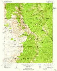 1954 Sandia Crest1955 Print · USGSThe high peaks and deep canyons of Bernalillo County come into sharp focus in the mid-1950s as recreation and infrastructure began to expand. Genealogists and hikers can trace old routes like the La Luz Trail or locate remote landmarks like Ellis Ranch and Cañoncito Cemetery.2 unique versions available
 - 1954 Map of Sandia Park, 1955 Print
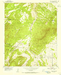 1954 Sandia Park1955 Print · USGSIn the Sandia Mountains during the mid-fifties, this area shows a quiet transition between old land grants and national forest. Researchers can trace ancestral sites and early industry at the Pa-ako Ruins, the Smelter Ruins, and the La Madera Cemetery.4 unique versions available
 - 1954 Map of Tijeras, 1955 Print
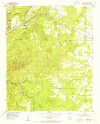
 1954 Tijeras1955 Print · USGSEast of Albuquerque in the mid-fifties, the mountain villages along the Cañon De Carnue Grant were key outposts on the road through the canyon. Genealogists and hikers can trace old routes like the Apachitos Trail or locate landmarks like the Santo Nino Cemetery and York Mine.2 unique versions available
 - 1954 Map of Sedillo, 1955 Print
 1954 Sedillo1955 Print · USGSThe high canyons of the Manzano Mountains are captured here in the mid-fifties as small settlements and mountain outposts dot the Cibola National Forest. Genealogists and historians can locate now-vanished sites like Sabino and the Piedmont Fur Farm alongside established communities like Sedillo.4 unique versions available
 - 1958 Map of Albuquerque
 1958 Albuquerque1958 Print · USGSAlbuquerque and the surrounding high desert are captured here during a period of massive federal expansion and postwar growth. Researchers can trace the development of Kirtland Air Force Base, find ancestral homes in Pueblo de Santa Ana, or locate industrial sites like the Jackpile Mine.
End of results
Showing maps 1-5 of 5
Top cities near Cedar Crest
- Albuquerque historical maps
- Rio Rancho historical maps
- Bernalillo historical maps
- Corrales historical maps
- Edgewood historical maps
- Tijeras historical maps
See more
Top neighborhoods of Cedar Crest
Frequently asked questions
- What are the different types of historical maps available for Cedar Crest?
- What is the oldest map of Cedar Crest?
- Where can I purchase historical maps of Cedar Crest for my home or office?
- Where can I download high-res historical maps of Cedar Crest?
- Are there historical topographic maps available for Cedar Crest?
- Is there historical aerial imagery available for Cedar Crest?
- Where are historical maps of Cedar Crest sourced from?