1990s Maps of Cedar Crest, New Mexico
Explore 5 historic maps of Cedar Crest from the 1990s. These maps offer a rare glimpse into what life looked like during the 1990s — showing old roads, neighborhoods, homes, and landmarks that have changed or disappeared over time.
Whether you're researching your family's past, planning a metal detecting trip, or studying how Cedar Crest's landscape evolved across the 1990s, these high-resolution maps are a powerful tool for exploring the history of this region.
- Focus on a specific era: All maps on this page are from the 1990s, giving you a focused view of this time period.
- See what’s changed: Compare century-old streets, trails, and buildings to today's modern landscape using overlays and satellite layers.
- Research with precision: Use these maps for genealogy, historical research, land use analysis, or educational projects.
- View, download, or print: Maps are fully viewable online in high resolution, and can be downloaded or printed for your own records.
Start exploring Cedar Crest's history through authentic maps from the 1990s. This is your window into the past.
Cedar Crest, NM maps
(5)- 1990 Map of Sandia Park, 1996 Print
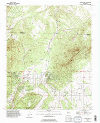 1990 Sandia Park1996 Print · USGSThe East Mountains of New Mexico come into sharp focus in the 1990s, revealing a landscape where ancestral sites and pioneer routes meet growing mountain communities. Trace historic transit lines like the Old Stagecoach Road or locate the Pa-ako Ruins and La Madera Cemetery.
 - 1990 Map of Tijeras, 1996 Print
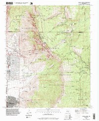
 1990 Tijeras1996 Print · USGSThe eastern edge of the Sandia Mountains meets the Albuquerque foothills during the early nineties as urban development presses against the Cibola National Forest. Researchers can trace historic mountain routes and local landmarks like Santo Nino Cem, the York Mine, and Carlito Springs.
 - 1990 Map of Sandia Crest, 1996 Print
 1990 Sandia Crest1996 Print · USGSThe high peaks of the Sandia Mountains and the expanding edge of Albuquerque meet here in the 1990s. Trace local history through landmarks like the Cañoncito Cemetery, the La Luz Mine, and the Sandia Peak Ski Area.2 unique versions available
 - 1990 Map of Sedillo, 1996 Print
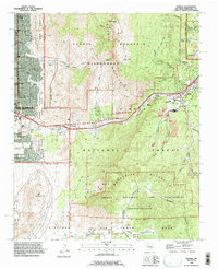
 1990 Sedillo1996 Print · USGSThe mountain communities of Bernalillo County are caught in a period of modern expansion along the historic U.S. 66 and Interstate 40 corridors. Researchers can trace the development of high-altitude settlements like Zuzax, Zamora, and Sedillo or locate landmarks such as the Animal Cemetery and Cedro Peak Communication Towers.
 - 1995 Map of Sedillo, 1998 Print
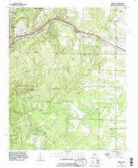
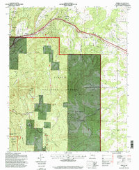 1995 Sedillo1998 Print · USGSThe mountains east of Albuquerque come alive in the 1990s as settlements like Sedillo and Cedar Crest line the historic corridor through Tijeras Canyon. Researchers can trace the bounds of Kirkland Air Force Base or locate family landmarks like Juan Tomas and Zamora.
End of results
Showing maps 1-5 of 5
Top cities near Cedar Crest
- Albuquerque historical maps
- Rio Rancho historical maps
- Bernalillo historical maps
- Corrales historical maps
- Edgewood historical maps
- Tijeras historical maps
See more
Top neighborhoods of Cedar Crest
Frequently asked questions
- What are the different types of historical maps available for Cedar Crest?
- What is the oldest map of Cedar Crest?
- Where can I purchase historical maps of Cedar Crest for my home or office?
- Where can I download high-res historical maps of Cedar Crest?
- Are there historical topographic maps available for Cedar Crest?
- Is there historical aerial imagery available for Cedar Crest?
- Where are historical maps of Cedar Crest sourced from?