1950s Maps of Grant County, New Mexico
Explore 34 historic maps of Grant County from the 1950s. These maps offer a rare glimpse into what life looked like during the 1950s — showing old roads, neighborhoods, homes, and landmarks that have changed or disappeared over time.
Whether you're researching your family's past, planning a metal detecting trip, or studying how Grant County's landscape evolved across the 1950s, these high-resolution maps are a powerful tool for exploring the history of this region.
- Focus on a specific era: All maps on this page are from the 1950s, giving you a focused view of this time period.
- See what’s changed: Compare century-old streets, trails, and buildings to today's modern landscape using overlays and satellite layers.
- Research with precision: Use these maps for genealogy, historical research, land use analysis, or educational projects.
- View, download, or print: Maps are fully viewable online in high resolution, and can be downloaded or printed for your own records.
Start exploring Grant County's history through authentic maps from the 1950s. This is your window into the past.
Grant County, NM maps
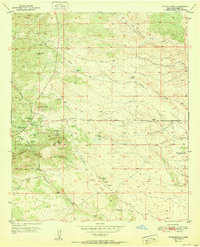
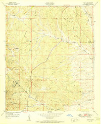
(34)- 1950 Map of Tyrone, 1955 Print
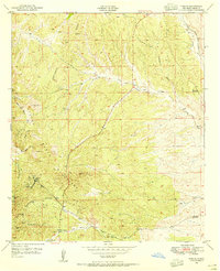 1950 Tyrone1955 Print · USGSMining operations in the Burro Mountains reached deep into the Grant County earth during the mid-century. Genealogists and historians can trace the industrial footprint of Tyrone and Oak Grove through numerous mines including the Klondike Tunnel and Rocket Shaft.
 - 1950 Map of White Signal, 1963 Print
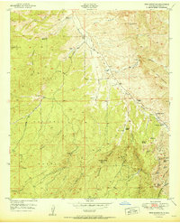
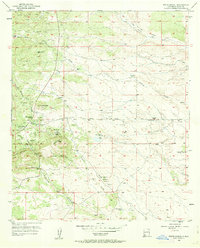 1950 White Signal1963 Print · USGSGrant County ranching and mining history come into focus in this mid-century survey of the New Mexico high country. Genealogists and researchers can locate the White Signal School and 7XV Ranch, or trace the paths to inactive sites like Gold Lake Mine.3 unique versions available
 - 1950 Map of Dorsey Ranch, 1963 Print
 1950 Dorsey Ranch1963 Print · USGSGrant County's high mesa country comes to life in the mid-century, showing the isolated homesteads and vital water sources that sustained life here. Trace the old routes of the Reading Canyon Trail and locate remote outposts like Burris H W Ranch and Avery Ranch.2 unique versions available
 - 1950 Map of Wind Mountain, 1967 Print
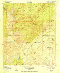
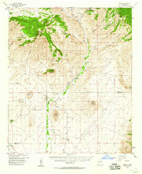
 1950 Wind Mountain1967 Print · USGSGrant County ranching and mining operations are captured here at mid-century as they sprawl across the Continental Divide. Researchers can locate family landmarks like Fleming Ranch or trace the many claims of the Little Burro Mountains, including the Burro Chief Mine and Indian Burial Ground.3 unique versions available
 - 1950 Map of Burro Peak, 1967 Print
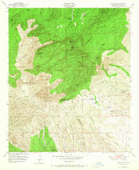 1950 Burro Peak1967 Print · USGSGrant County ranching and mining operations are captured here during the 1950s as the high desert landscape was mapped in detail. Genealogists and historians can trace family sites like Silsby Ranch and the Burro Mountain Homestead, or locate mineral prospects such as the Red Hill Turquoise Mine and the Merry Widow Shaft.
 - 1950 Map of Silver City, 1968 Print
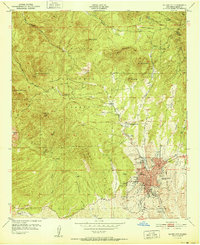
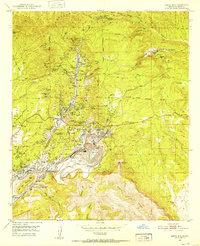
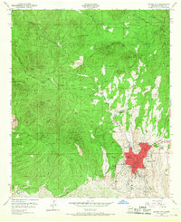 1950 Silver City1968 Print · USGSSilver City at the mid-century serves as a gateway to the high timber of the Gila National Forest. Researchers can locate the Atchison Topeka and Santa Fe rail line, the historic Boston Hill quarries, and St Marys Academy.2 unique versions available
 - 1950 Map of Reading Mountain, 1969 Print
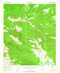
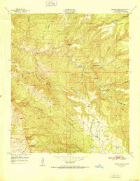
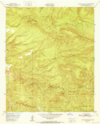
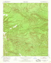 1950 Reading Mountain1969 Print · USGSThe Pinos Altos Range in the mid-twentieth century is captured here in detail, showcasing the high-elevation wilderness of the Gila National Forest. Researchers can find isolated landmarks like Snow Creek Cabin, Allen Springs, and Preachers Point.2 unique versions available
 - 1951 Map of Circle Mesa
 1951 Circle Mesa1951 Print · USGSGrant County ranchlands and forest canyons are documented here in the early postwar era. Researchers can locate specific family holdings like the J McMillen Ranch and Sherman Ranch or trace water sources from Mangas Creek to Ash Spring.
 - 1951 Map of White Signal
 1951 White Signal1951 Print · USGSThe mining and ranching culture of mid-century Grant County is captured here, centered on the settlement of White Signal. Researchers can trace the locations of family-owned operations and landmarks like the 7XV Ranch, White Signal School, and the Apache Trail Mine.
 - 1951 Map of Dorsey Ranch
 1951 Dorsey Ranch1951 Print · USGSThe high ranching country of Grant County is captured here in the early fifties, showing a landscape shaped by remote outposts and seasonal camps. Researchers can trace the locations of Dorsey Ranch, Avery Ranch, and the isolated Dorsey Camp among the deep draws of Hells Half Acre Canyon.
 - 1951 Map of Silver City
 1951 Silver City1951 Print · USGSSilver City was evolving into a regional mountain hub in the early fifties, caught between its mining roots and its growing role as a college town. Genealogists and researchers can locate New Mexico Western College, St Marys Academy, and the Cottage Sanatorium on this detailed sheet.
 - 1951 Map of Big Burro Mountains
 1951 Big Burro Mountains1951 Print · USGSHigh desert mining and ranching define the Grant County landscape in the early fifties as the Continental Divide winds through the high peaks. Genealogists and historians can locate family operations like the Silsby Ranch or trace mineral claims at the Merry Widow Shaft and Austin Amazon Mines.2 unique versions available
 - 1951 Map of Tyrone
 1951 Tyrone1951 Print · USGSThe Little Burro Mountains were a hive of mineral extraction in the early fifties, centering on the mining town of Tyrone. Researchers can trace historic industrial footprints like the Gettysburg Shaft, Niagara Tunnel, and the local Cem.2 unique versions available
 - 1951 Map of Wind Mountain
 1951 Wind Mountain1951 Print · USGSGrant County, New Mexico, was a rugged frontier of active mining and family ranching in the years following World War II. Researchers can trace historic family holdings like Woodward Ranch and Ridout Ranch alongside an Indian Burial Ground and the Shrine Mine.
 - 1951 Map of Santa Rita, 1953 Print
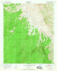
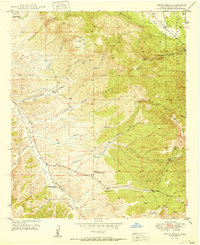
 1951 Santa Rita1953 Print · USGSMining operations transformed this corner of New Mexico by the early fifties, centering on the massive pits and bustling camps of the Chino copper district. Genealogists and historians can locate the residential streets of Santa Rita, the Hanover Sch, and the earlier Georgetown (Ruins).4 unique versions available
 - 1952 Map of Reading Mountain
 1952 Reading Mountain1952 Print · USGSHigh in the Pinos Altos Range during the early fifties, this backcountry survey shows the rugged heart of the Gila National Forest. Researchers can trace old mountain landmarks like Snow Creek Cabin, Preachers Point, and the Dorsey Ranch.
 - 1954 Map of Tularosa, 1963 Print
 1954 Tularosa1963 Print · USGSSouth-central New Mexico in the early fifties shows a landscape of desert basins and high peaks under heavy military and water-reclamation use. Trace the path of the Atchison Topeka and Santa Fe Railway past San Marcial and into the massive White Sands Proving Ground.4 unique versions available
 - 1954 Map of Silver City, 1967 Print
 1954 Silver City1967 Print · USGSSoutheast Arizona and southwest New Mexico meet in this mid-century survey of the high desert and mountain mining districts. Local researchers can trace the rail lines through Lordsburg, the silver operations at Ash Peak Mines, and the limits of Fort Bayard Military Reservation.4 unique versions available
 - 1954 Map of Clifton, 1968 Print
 1954 Clifton1968 Print · USGSThe high timber and copper country of the Arizona-New Mexico border is captured here during the mid-fifties. Genealogists and historians can trace family holdings like the Double Circle Ranch or study the industrial footprint of the Smelting Plant at Clifton.3 unique versions available
 - 1955 Map of Douglas
 1955 Douglas1955 Print · USGSThe Arizona and New Mexico borderlands come into focus in the mid-1950s, highlighting the mining and ranching hubs of the Desert Southwest. Genealogists and historians can trace the foundations of Bisbee, the operations at Hachita Mine, and rural landmarks like the Double Adobe School.2 unique versions available
 - 1955 Map of Las Cruces, 1963 Print
 1955 Las Cruces1963 Print · USGSSouthern New Mexico comes into focus during the mid-fifties, showing the growth of Las Cruces alongside major military and scientific installations. Genealogists and historians can trace the Southern Pacific tracks through small rail towns like Cambray and Afton, or locate family sites near Hatch and Deming.3 unique versions available
 - 1956 Map of Dwyer, 1958 Print
 1956 Dwyer1958 Print · USGSThe Mimbres River valley was a vital corridor of ranching and early mining in the 1950s. Genealogists and historians can trace family roots through the Dwyer (Faywood PO) settlement, San Jose Ch, and the high-country Big Mill.2 unique versions available
 - 1956 Map of San Lorenzo, 1959 Print
 1956 San Lorenzo1959 Print · USGSThe Mimbres River valley and the high Black Range come together in this mid-century survey of Grant and Sierra counties. Researchers can trace the development of mining operations like the Royal John Mine and the Columbia Mine alongside the historic villages of San Lorenzo and San Juan.2 unique versions available
 - 1957 Map of Clifton
 1957 Clifton1957 Print · USGSThe copper-mining district around Clifton and Morenci meets the high timberlands of the Mogollon Rim during the mid-1950s. Genealogists and researchers can trace family-named outposts and remote mountain settlements like Reserve, Stargo, and Fort Thomas.
 - 1958 Map of Las Cruces
 1958 Las Cruces1958 Print · USGSSouthern New Mexico in the late fifties was a landscape of rapid scientific and military growth centered on the Rio Grande. Local historians can trace the development of Las Cruces, the campus of New Mexico A and M College, and remote rail sidings like Aden Siding.
Showing maps 1-25 of 34
Top cities of Grant County
Frequently asked questions
- What are the different types of historical maps available for Grant County?
- What is the oldest map of Grant County?
- Where can I purchase historical maps of Grant County for my home or office?
- Where can I download high-res historical maps of Grant County?
- Are there historical topographic maps available for Grant County?
- Is there historical aerial imagery available for Grant County?
- Where are historical maps of Grant County sourced from?