1910s Maps of Grant County, New Mexico
Explore 10 historic maps of Grant County from the 1910s. These maps offer a rare glimpse into what life looked like during the 1910s — showing old roads, neighborhoods, homes, and landmarks that have changed or disappeared over time.
Whether you're researching your family's past, planning a metal detecting trip, or studying how Grant County's landscape evolved across the 1910s, these high-resolution maps are a powerful tool for exploring the history of this region.
- Focus on a specific era: All maps on this page are from the 1910s, giving you a focused view of this time period.
- See what’s changed: Compare century-old streets, trails, and buildings to today's modern landscape using overlays and satellite layers.
- Research with precision: Use these maps for genealogy, historical research, land use analysis, or educational projects.
- View, download, or print: Maps are fully viewable online in high resolution, and can be downloaded or printed for your own records.
Start exploring Grant County's history through authentic maps from the 1910s. This is your window into the past.
Grant County, NM maps
(10)- 1910 Map of Mogollon, 1959 Print
 1910 Mogollon1959 Print · USGSThe high mining camps and river settlements of Catron County come alive in this survey from the early 1900s. Genealogists and historians can trace old homesteads and industrial sites like the Meader Stage Sta, Box N Ranch, and the Power Plant near Graham.2 unique versions available
 - 1911 Map of Alum Mountain, 1959 Print
 1911 Alum Mountain1959 Print · USGSThe upper Gila River wilderness is documented here just after the turn of the century, showing a landscape of remote cattle ranches and early mining claims. Genealogists and researchers can trace family-named sites like TJ Ranch and the Meerschaum Mine, or locate the Gila Cliff-Dwellings National Monument.
 - 1912 Map of Mogollon
 1912 Mogollon1912 Print · USGSNew Mexico's high timber and mining country come to life in this survey from the years just before statehood. Researchers can trace the early industrial footprint of Cooney and Mogollon or locate remote outposts like Meadows Stage Sta and N Bar Ranch.2 unique versions available
 - 1913 Map of Alum Mountain
 1913 Alum Mountain1913 Print · USGSNew Mexico's high wilderness is captured here just after statehood, documenting the remote ranching outposts and ancient sites along the Gila River. Researchers can locate early twentieth-century landmarks like Gila Cliff Dwellings National Monument, the Meerschaum Mine, and the XSX Ranch.3 unique versions available
 - 1913 Map of Morenci, 1954 Print
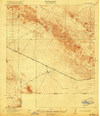
 1913 Morenci1954 Print · USGSArizona's copper country and high timberlands meet in this pre-war survey of the Morenci district and Apache National Forest. Researchers can trace the early industrial footprint of Morenci and Clifton or find family landmarks like Miller Cabin and Cooks Ranch.2 unique versions available
 - 1915 Map of Morenci
 1915 Morenci1915 Print · USGSGreenlee County during the early 1900s shows a landscape defined by industrial copper mining and isolated high-desert ranching. Genealogists and historians can trace family locations from the Eagle Creek School to historic homesteads like Dudley Ranch and the settlement of Oroville.3 unique versions available
 - 1918 Map of Hachita
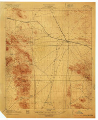 1918 Hachita1918 Print · USGSIn the southwestern New Mexico desert during the Great War, the rail hub at Hachita connected vital mining and ranching interests. Trace the early mining camps of Old Hachita and Sylvanite, or follow the Hueco Alamo Road to the remote Twelvemile Wells.4 unique versions available
 - 1918 Map of Victorio
 1918 Victorio1918 Print · USGSThe New Mexico borderlands during the Great War era reveal a landscape of isolated ranching outposts and international mining operations. Researchers can locate family landmarks like Bud Williams Ranch and trace the historic El Paso and Southwestern rail line.3 unique versions available
 - 1918 Map of Playas, 1961 Print
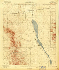
 1918 Playas1961 Print · USGSThe Playas Valley in the late nineteen-teens shows a landscape of isolated rail stops and cattle ranches at the edge of the desert. Researchers can trace early transit routes along the El Paso and Southwestern and locate family landmarks like Whitmire Ranch.3 unique versions available
 - 1919 Map of Playas
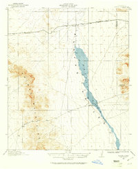
 1919 Playas1919 Print · USGSThe Playas Valley was a critical ranching and rail corridor in the high desert during the early twentieth century. Researchers can trace the path of the El Paso and Southwestern railroad and locate early sites like Whitmire Ranch and Antelope.4 unique versions available
End of results
Showing maps 1-10 of 10
Top cities of Grant County
Frequently asked questions
- What are the different types of historical maps available for Grant County?
- What is the oldest map of Grant County?
- Where can I purchase historical maps of Grant County for my home or office?
- Where can I download high-res historical maps of Grant County?
- Are there historical topographic maps available for Grant County?
- Is there historical aerial imagery available for Grant County?
- Where are historical maps of Grant County sourced from?