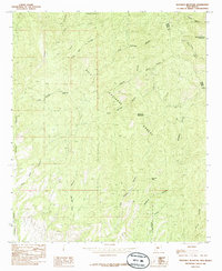
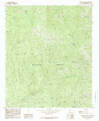
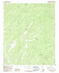
1980s Maps of Grant County, New Mexico
Explore 27 historic maps of Grant County from the 1980s. These maps offer a rare glimpse into what life looked like during the 1980s — showing old roads, neighborhoods, homes, and landmarks that have changed or disappeared over time.
Whether you're researching your family's past, planning a metal detecting trip, or studying how Grant County's landscape evolved across the 1980s, these high-resolution maps are a powerful tool for exploring the history of this region.
- Focus on a specific era: All maps on this page are from the 1980s, giving you a focused view of this time period.
- See what’s changed: Compare century-old streets, trails, and buildings to today's modern landscape using overlays and satellite layers.
- Research with precision: Use these maps for genealogy, historical research, land use analysis, or educational projects.
- View, download, or print: Maps are fully viewable online in high resolution, and can be downloaded or printed for your own records.
Start exploring Grant County's history through authentic maps from the 1980s. This is your window into the past.
Grant County, NM maps
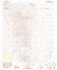
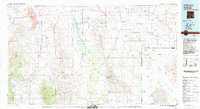
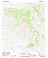
(27)- 1981 Map of Lordsburg
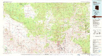
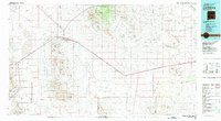 1981 Lordsburg1981 Print · USGSHidalgo County in the early eighties remains a landscape defined by the copper-and-rail economy and the long stretch of the Continental Divide. Genealogists and historians can trace the paths of the Southern Pacific and small settlements like Cotton City or find remote workings such as the Golden Cross Mine.
 - 1982 Map of Playas Lake North
 1982 Playas Lake North1982 Print · USGSHidalgo County's industrial desert landscape is captured here in the early eighties as the town of Playas took shape. Researchers can trace the development of this company town, from its Phelps Dodge Industrial R.R. connection to the Trailer Park and Hellport.
 - 1982 Map of Playas Lake South
 1982 Playas Lake South1982 Print · USGSHidalgo County industry and desert geography meet in the early 1980s as mining and refining operations expanded near the dry basin. Researchers can locate the massive Smelter complex and trace water management features from Whitmire Spring to Playas Lake.
 - 1982 Map of Doyle Peak
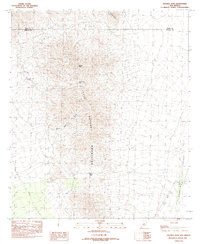
 1982 Doyle Peak1982 Print · USGSThe high desert of Hidalgo County in the early eighties is defined here by the steep elevations of the Apache Hills and the Hachita Valley. Researchers can trace the isolated landscape around Doyle Peak, Quartzite Ridge, and cattle tanks like Chapo Tank.
 - 1982 Map of Hachita
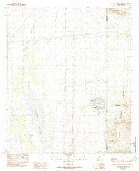
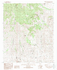
 1982 Hachita1982 Print · USGSIn the early eighties, this desert landscape along the Grant and Hidalgo county line reveals a history of mining and exploration. Researchers can trace historic activity through the Mine Shaft and Prospects found near Hachita Peak and Stone Cabin Gulch.2 unique versions available
 - 1982 Map of Hachita Peak
 1982 Hachita Peak1982 Print · USGSThe Little Hatchet Mountains in the early 1980s reveal a landscape shaped by mining and high-desert passes. Researchers can trace historical resource extraction at a Mine Shaft and Prospects or locate the remote Cottonwood Spring.
 - 1982 Map of Playas Peak
 1982 Playas Peak1982 Print · USGSThe high desert of Grant County in the early eighties is captured here, centered on the Little Hatchet Mountains. Trace the path of the Continental Divide as it passes landmarks like Turquoise Mountain and Playas Peak.
 - 1982 Map of Hatch
 1982 Hatch1982 Print · USGSThe Rio Grande valley and the rugged Mimbres Mountains meet in this early 1980s overview of southern New Mexico. Researchers can trace the path of the Atchison Topeka and Santa Fe railroad or locate historic mining hubs like Hillsboro and Lake Valley.
 - 1983 Map of Animas
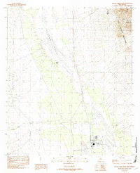
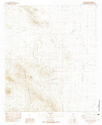
 1983 Animas1983 Print · USGSSouthern New Mexico’s Bootheel remains a landscape of high-desert ranching and remote mining districts during the early eighties. Researchers can trace the Southern Pacific Railroad past historic hubs like Animas and Hachita or locate mining sites such as the Gillespie Mine.
 - 1985 Map of Dwyer
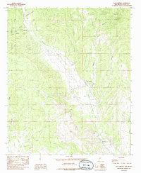
 1985 Dwyer1985 Print · USGSThe Mimbres River valley in the mid-1980s reveals a landscape of isolated springs and rugged canyon drainages. Researchers can trace the settlement at Swartz, the post office at Dwyer, and historical mining Prospects near Cordwood Draw.
 - 1985 Map of P A Mountain
 1985 P A Mountain1985 Print · USGSHigh desert peaks and hidden water sources define the Sierra County wilderness during the mid-1980s. Researchers can locate remote landmarks like Larkins Spring, Seven Brothers Mountain, and the isolated O Bar O Canyon along the Grant County border.
 - 1985 Map of San Lorenzo
 1985 San Lorenzo1985 Print · USGSSettlements along the Mimbres River valley in the mid-1980s reflect a long history of water management and mountain ranching. Researchers can trace irrigation networks and find local landmarks like San Lorenzo, San Juan, and the secluded Willow Springs.
 - 1985 Map of Dwyer SE
 1985 Dwyer SE1985 Print · USGSThe high desert of Luna and Grant counties is captured here in the mid-1980s, dominated by the peaks of the Cookes Range. Trace the seasonal drainage patterns of Cordwood Draw and Butterfield Draw as they wind past landmarks like Round Mountain.
 - 1985 Map of Taylor Mountain
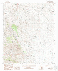
 1985 Taylor Mountain1985 Print · USGSThe high-desert terrain of the Grant and Luna county line is shown here in the mid-1980s, centered on the Mimbres River valley. Genealogists and historians can trace the settlement at Old Town, locate the local Cem, and explore the geological features of City of Rocks State Park.
 - 1985 Map of Whitehorse Mountain
 1985 Whitehorse Mountain1985 Print · USGSGrant County high country in the mid-1980s reveals a landscape shaped by water scarcity and ranching. Genealogists and historians can trace family-named landmarks like Tom Brown Canyon alongside essential water sources such as Seneca Tanks and Clark Tanks.
 - 1985 Map of Mogollon Mountains
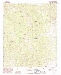
 1985 Mogollon Mountains1985 Print · USGSThe high wilderness of Catron and Grant counties is shown in the mid-1980s, documenting the remote canyons and peaks of the Gila region. Researchers can trace the proximity of historic mining sites like Confidence Mine to small mountain towns such as Mogollon and Glenwood.
 - 1985 Map of Maverick Mountain
 1985 Maverick Mountain1985 Print · USGSThe high canyons and peaks of the Gila National Forest are documented here during the mid-1980s. Local history researchers and outdoorsmen can trace the location of early Mines and natural water sources like Cold Springs and Hot Springs.
 - 1985 Map of Hillsboro Peak
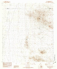
 1985 Hillsboro Peak1985 Print · USGSThe high peaks of the Black Range are captured here in the mid-1980s as they straddle the Grant and Sierra County line. Researchers can trace remote pack trails and locate high-altitude landmarks like Hillsboro Peak, Emory Pass, and Sawyers Peak.2 unique versions available
 - 1985 Map of Hendricks Peak
 1985 Hendricks Peak1985 Print · USGSGrant County’s high-desert wilderness is documented here in the mid-1980s as it sits within the Gila National Forest. Researchers can locate isolated water sources and natural landmarks like Hendricks Peak, City of Rocks, and Bear Canyon Reservoir.
 - 1986 Map of Clifton, 1987 Print
 1986 Clifton1987 Print · USGSArizona's copper country and the rugged borderlands come into sharp focus in the mid-1980s. Researchers can trace the massive Morenci Open Pit and its rail connections to Clifton, alongside remote outposts like Point of Pines and Fort Thomas.2 unique versions available
 - 1986 Map of Tillie Hall Peak, 1987 Print
 1986 Tillie Hall Peak1987 Print · USGSThe Arizona-New Mexico borderlands in the mid-1980s show a high-country landscape of national forests and isolated mountain peaks. Researchers can locate remote resource extractions like a Mine or Prospect and trace drainages from Hells Hole Canyon to Bitter Creek.
 - 1986 Map of Goat Camp Spring, 1987 Print
 1986 Goat Camp Spring1987 Print · USGSThe high desert along the Arizona-New Mexico border in the 1980s reveals a landscape of isolated mining claims and spring-fed camps. Researchers can trace historic activity at Goat Camp Spring, several scattered Mines, and the settlement at Hunter Flat.
 - 1989 Map of White Rock Mountain
 1989 White Rock Mountain1989 Print · USGSThe high ridges of the Sierra and Grant county border come alive in the late eighties, documenting a landscape of isolated springs and prominent peaks. Trace the rugged terrain from Whiterock Mountain to the remote Mine Shaft near Log Springs Mountain.
 - 1989 Map of Ok Canyon
 1989 Ok Canyon1989 Print · USGSThe Cookes Range serves as the center of this late twentieth-century study of the high desert and its mining history. Researchers can locate the Cooks Peak (Site) and trace numerous Mine Shafts and Prospects near Finger-Ring Draw.
 - 1989 Map of Greg Hills
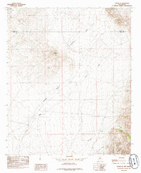
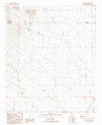 1989 Greg Hills1989 Print · USGSSouthern New Mexico ranching country is captured here during the late eighties at the intersection of three counties. Researchers can trace vital water sources and land improvements like Cotton Well, China Tank, and the winding Macho Creek.
Showing maps 1-25 of 27
Top cities of Grant County
Frequently asked questions
- What are the different types of historical maps available for Grant County?
- What is the oldest map of Grant County?
- Where can I purchase historical maps of Grant County for my home or office?
- Where can I download high-res historical maps of Grant County?
- Are there historical topographic maps available for Grant County?
- Is there historical aerial imagery available for Grant County?
- Where are historical maps of Grant County sourced from?