1890s Maps of Guadalupe County, New Mexico
Explore 5 historic maps of Guadalupe County from the 1890s. These maps offer a rare glimpse into what life looked like during the 1890s — showing old roads, neighborhoods, homes, and landmarks that have changed or disappeared over time.
Whether you're researching your family's past, planning a metal detecting trip, or studying how Guadalupe County's landscape evolved across the 1890s, these high-resolution maps are a powerful tool for exploring the history of this region.
- Focus on a specific era: All maps on this page are from the 1890s, giving you a focused view of this time period.
- See what’s changed: Compare century-old streets, trails, and buildings to today's modern landscape using overlays and satellite layers.
- Research with precision: Use these maps for genealogy, historical research, land use analysis, or educational projects.
- View, download, or print: Maps are fully viewable online in high resolution, and can be downloaded or printed for your own records.
Start exploring Guadalupe County's history through authentic maps from the 1890s. This is your window into the past.
Guadalupe County, NM maps
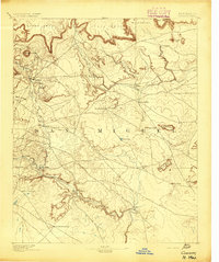
(5)- 1890 Map of Bernal, 1956 Print
 1890 Bernal1956 Print · USGSSettlements along the Pecos River valley and the critical rail corridor of the late nineteenth century define this New Mexico landscape. Researchers can trace the early rail stops and traditional plazas of San Miguel, Old Bernal, and Anton Chico.
 - 1891 Map of Bernal
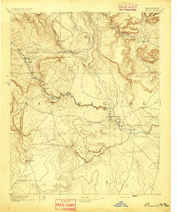
 1891 Bernal1891 Print · USGSNorthern New Mexico's river valleys and mesa lands are captured here just as the railroad began transforming the territory's commerce. Genealogists can trace family roots in historic plazas like San Miguel, La Cuesta, and San Jose before modern development changed these rural corridors.
 - 1892 Map of Corazon
 1892 Corazon1892 Print · USGSSan Miguel County in the early 1890s reveals a territory of high mesas and vital water sources before modern development. Genealogists and researchers can locate early plazas and villages such as Chaperito, Aguila, and Las Colonias, or trace family landmarks like Cabra Spring.2 unique versions available
 - 1894 Map of Corazon
 1894 Corazon1894 Print · USGSSan Miguel county in the 1890s was a landscape of high mesas and vital river settlements. Genealogists and historians can trace early territory life through named springs and remote outposts like Chaperito, Las Colonias, and Concha Spring.5 unique versions available
 - 1894 Map of Bernal
 1894 Bernal1894 Print · USGSSan Miguel County at the end of the nineteenth century is captured here as the railroad began to reshape the old river settlements. Genealogists can trace family roots in historic villages like Old Bernal, Anton Chico, and La Liendre.4 unique versions available
End of results
Showing maps 1-5 of 5
Top cities of Guadalupe County
Frequently asked questions
- What are the different types of historical maps available for Guadalupe County?
- What is the oldest map of Guadalupe County?
- Where can I purchase historical maps of Guadalupe County for my home or office?
- Where can I download high-res historical maps of Guadalupe County?
- Are there historical topographic maps available for Guadalupe County?
- Is there historical aerial imagery available for Guadalupe County?
- Where are historical maps of Guadalupe County sourced from?