1980s Maps of Guadalupe County, New Mexico
Explore 12 historic maps of Guadalupe County from the 1980s. These maps offer a rare glimpse into what life looked like during the 1980s — showing old roads, neighborhoods, homes, and landmarks that have changed or disappeared over time.
Whether you're researching your family's past, planning a metal detecting trip, or studying how Guadalupe County's landscape evolved across the 1980s, these high-resolution maps are a powerful tool for exploring the history of this region.
- Focus on a specific era: All maps on this page are from the 1980s, giving you a focused view of this time period.
- See what’s changed: Compare century-old streets, trails, and buildings to today's modern landscape using overlays and satellite layers.
- Research with precision: Use these maps for genealogy, historical research, land use analysis, or educational projects.
- View, download, or print: Maps are fully viewable online in high resolution, and can be downloaded or printed for your own records.
Start exploring Guadalupe County's history through authentic maps from the 1980s. This is your window into the past.
Guadalupe County, NM maps
(12)- 1980 Map of Corona, 1981 Print
 1980 Corona1981 Print · USGSThe high-desert ranching and rail country of Lincoln County is documented here during the early eighties. Genealogists and local historians can trace the Southern Pacific line through Corona, locate the Old Railroad Grade, and find remote outposts like Claunch and Gallinas.
 - 1981 Map of Loco Draw
 1981 Loco Draw1981 Print · USGSLincoln County ranch lands are captured here in the early 1980s, showing a landscape defined by water management and open range. Researchers can trace the layout of the Mile High Ranch and locate remote livestock features like Barvel Lake and Twin Windmills.
 - 1981 Map of Gacho Hill NW
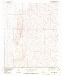 1981 Gacho Hill NW1981 Print · USGSGuadalupe County ranching lands are captured in the early eighties just as infrastructure began to cross the high plains. Researchers can trace family-named sites like Vicente Ranch and Del Curto Ranch alongside the path of Marino Draw.
 - 1981 Map of Gacho Hill SW
 1981 Gacho Hill SW1981 Print · USGSThe high desert of Lincoln and Guadalupe counties is captured here in the early eighties, showing a landscape shaped by water and ranching. Researchers can locate remote watering points like Shinery Well and Boggie Well or trace the early path of a local Pipeline.
 - 1981 Map of Camaleon Draw East
 1981 Camaleon Draw East1981 Print · USGSRanching life in central New Mexico is documented here in the early 1980s, centered on the tri-county intersection and vital water sources. Trace historical livestock infrastructure through sites like Telephone Lake, Old Five Wire Well, and Rivera Well.
 - 1981 Map of Gacho Hill SE
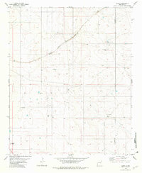
 1981 Gacho Hill SE1981 Print · USGSNew Mexico's high-desert ranching country is captured here in the early 1980s as the state managed water and energy across the county line. Researchers can trace land use through named features like Roadrunner Ranch, Manzanita Lake, and Mc Lemore Well.
 - 1981 Map of Duran NE
 1981 Duran NE1981 Print · USGSEastern Torrance County ranching life is preserved here during the early eighties, where water meant survival for livestock and settlers. Trace the Southern Pacific rail line or locate family-named landmarks like Hindi Ranch and Duran Cem.
 - 1981 Map of Gacho Hill
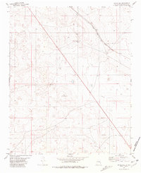 1981 Gacho Hill1981 Print · USGSGuadalupe County ranching and rail infrastructure are captured here in the early eighties. Researchers can trace the path of the Atchison Topeka and Santa Fe railroad and locate sparse water sources like Seven Lakes Well and Gacho Well.
 - 1981 Map of Duoro, 1982 Print
 1981 Duoro1982 Print · USGSRanching and rail transport dominate this eastern New Mexico landscape in the early eighties. Genealogists and researchers can trace vital water sources and family-named landmarks like Byrd Ranch, Snell Well, and the remote station at Duoro.
 - 1983 Map of Villanueva, 1984 Print
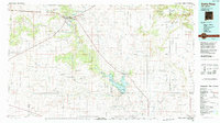
 1983 Villanueva1984 Print · USGSThe Pecos River valley and its high mesa surroundings are captured here in the early eighties. Researchers can trace historic river settlements like Villanueva and Sena, the route of the Atchison Topeka and Santa Fe railroad, and the high-desert terrain of Glorieta Mesa.
 - 1984 Map of Vaughn, 1992 Print
 1984 Vaughn1992 Print · USGSCentral New Mexico’s high plains are captured here in the mid-1980s, revealing a landscape shaped by transcontinental rail and highway travel. Trace the paths of the Atchison Topeka and Santa Fe through settlements like Encino, Vaughn, and Milagro.
 - 1984 Map of Santa Rosa, 1992 Print
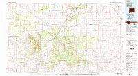
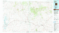
 1984 Santa Rosa1992 Print · USGSEast-central New Mexico is captured here in the mid-1980s, centered on the strategic river crossing at Santa Rosa. Researchers can trace family-named landforms and small outposts like Puerto de Luna, Pastura, and the varied arroyos feeding into Lake Sumner.
End of results
Showing maps 1-12 of 12
Top cities of Guadalupe County
Frequently asked questions
- What are the different types of historical maps available for Guadalupe County?
- What is the oldest map of Guadalupe County?
- Where can I purchase historical maps of Guadalupe County for my home or office?
- Where can I download high-res historical maps of Guadalupe County?
- Are there historical topographic maps available for Guadalupe County?
- Is there historical aerial imagery available for Guadalupe County?
- Where are historical maps of Guadalupe County sourced from?