1980s Maps of Mora County, New Mexico
Explore 8 historic maps of Mora County from the 1980s. These maps offer a rare glimpse into what life looked like during the 1980s — showing old roads, neighborhoods, homes, and landmarks that have changed or disappeared over time.
Whether you're researching your family's past, planning a metal detecting trip, or studying how Mora County's landscape evolved across the 1980s, these high-resolution maps are a powerful tool for exploring the history of this region.
- Focus on a specific era: All maps on this page are from the 1980s, giving you a focused view of this time period.
- See what’s changed: Compare century-old streets, trails, and buildings to today's modern landscape using overlays and satellite layers.
- Research with precision: Use these maps for genealogy, historical research, land use analysis, or educational projects.
- View, download, or print: Maps are fully viewable online in high resolution, and can be downloaded or printed for your own records.
Start exploring Mora County's history through authentic maps from the 1980s. This is your window into the past.
Mora County, NM maps
(8)- 1981 Map of Springer
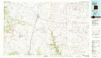 1981 Springer1981 Print · USGSNortheast New Mexico in the early eighties remains a landscape defined by its deep historical pathways and massive land grants. Genealogists and historians can trace the original Santa Fe Trail routes, the State Boys School at Springer, and the landmarks of Wagon Mound.
 - 1981 Map of Roy, 1982 Print
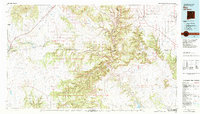 1981 Roy1982 Print · USGSNortheastern New Mexico's ranching and volcanic landscapes are documented here in the early eighties. Researchers can trace the Santa Fe Trail, locate the historic Fort Union Nat Mon, and explore the rail corridor through Roy and Solano.
 - 1983 Map of Taos
 1983 Taos1983 Print · USGSNorthern New Mexico's high-country heritage is on full display in the early eighties, from the deep river canyons to the highest alpine peaks. Genealogists and historians can trace traditional land-grant settlements like Las Trampas, Truchas, and the historic Taos Pueblo.2 unique versions available
 - 1983 Map of Santa Fe, 1984 Print
 1983 Santa Fe1984 Print · USGSThe high Sangre de Cristo Mountains and the growing state capital define this early 1980s landscape during a period of expanding infrastructure. Researchers can trace historic land patterns and transit routes from Nambe Pueblo and Glorieta Pass to the Atchison Topeka and Santa Fe RR line.
 - 1987 Map of Agua Fria Peak
 1987 Agua Fria Peak1987 Print · USGSHigh-altitude ranchlands and scout territories meet in the late 1980s along the Colfax and Mora county line. Researchers can trace the varied terrain of the Philmont Scout Ranch or locate landmarks like Agua Fria Peak and Hidden Lake.
 - 1987 Map of White Peak
 1987 White Peak1987 Print · USGSColfax and Mora counties in the late 1980s showcase a high-elevation landscape of historic land grants and ranching outposts. Researchers can trace the ranching economy through sites like Mora Ranch, La Grulla Cow Camp, and the White Peak Lookout Tower.
 - 1987 Map of Rayado
 1987 Rayado1987 Print · USGSColfax County ranching and scout history are well-preserved in this 1980s survey of the high mesas and historic trails. Researchers can trace the path of the Santa Fe Trail and locate sites like Rayado Camp, Sunny Side, and the local Cem.
 - 1987 Map of Miami
 1987 Miami1987 Print · USGSColfax County's high mesa country is captured here in the late eighties, showing the intersection of historic land grants and ranching life. Genealogists and historians can locate the Cem near Miami, trace the Abandoned Canal, and find old sites like Salado and Alona.
End of results
Showing maps 1-8 of 8
Top cities of Mora County
Frequently asked questions
- What are the different types of historical maps available for Mora County?
- What is the oldest map of Mora County?
- Where can I purchase historical maps of Mora County for my home or office?
- Where can I download high-res historical maps of Mora County?
- Are there historical topographic maps available for Mora County?
- Is there historical aerial imagery available for Mora County?
- Where are historical maps of Mora County sourced from?