1990s Maps of Mora County, New Mexico
Explore 19 historic maps of Mora County from the 1990s. These maps offer a rare glimpse into what life looked like during the 1990s — showing old roads, neighborhoods, homes, and landmarks that have changed or disappeared over time.
Whether you're researching your family's past, planning a metal detecting trip, or studying how Mora County's landscape evolved across the 1990s, these high-resolution maps are a powerful tool for exploring the history of this region.
- Focus on a specific era: All maps on this page are from the 1990s, giving you a focused view of this time period.
- See what’s changed: Compare century-old streets, trails, and buildings to today's modern landscape using overlays and satellite layers.
- Research with precision: Use these maps for genealogy, historical research, land use analysis, or educational projects.
- View, download, or print: Maps are fully viewable online in high resolution, and can be downloaded or printed for your own records.
Start exploring Mora County's history through authentic maps from the 1990s. This is your window into the past.
Mora County, NM maps
(19)- 1994 Map of Ojo Feliz, 1998 Print
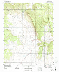
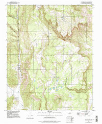
 1994 Ojo Feliz1998 Print · USGSMora County ranching and settlement patterns are captured here in the mid-nineties, showing the rural landscape around Ojo Feliz. Genealogists and local historians can trace family sites at San Ysidro or locate the Casias Cem and Pelon Windmill.
 - 1994 Map of Comanche Peak, 1998 Print
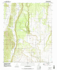
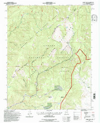
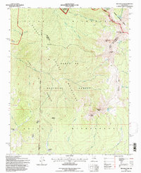
 1994 Comanche Peak1998 Print · USGSThe northern Mora Mountains and high valley floor come into sharp focus in the late twentieth century. Genealogists and local historians can trace family roots through the St Teresa Ch / Cem, the village of El Turquillo, and Immaculate Heart of Mary Cem.
 - 1994 Map of Lucero, 1998 Print
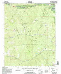
 1994 Lucero1998 Print · USGSMora County in the 1990s reveals a network of traditional Hispanic settlements and high-plateau landmarks. Genealogists and historians can trace family-named sites like Los Cisneros, Los Medinas, and the ruins of El Convento.
 - 1994 Map of Ocate, 1998 Print
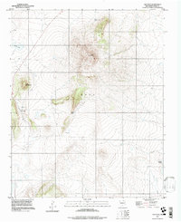
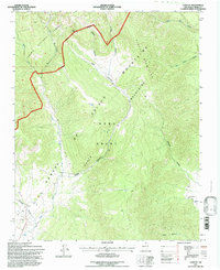
 1994 Ocate1998 Print · USGSMora County ranchlands and mesa country are frozen in time during the mid-1990s as this survey documents a high-altitude landscape of isolated peaks and remote settlements. Genealogists and local historians can locate the Ocate Mission, Guadalupe Ch, and the Strong Cem while tracing the winding path of Ocate Creek.
 - 1994 Map of Guadalupita, 1998 Print
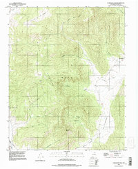
 1994 Guadalupita1998 Print · USGSThe Mora high country in the mid-1990s reveals a landscape of isolated settlements and high mesas. Researchers can trace the layout of Guadalupita, locate the borders of Coyote Creek State Park, and find small landmarks like Cowboy Lake or the Prospect site.
 - 1994 Map of Agua Fria Peak, 1998 Print
 1994 Agua Fria Peak1998 Print · USGSHigh-altitude New Mexico territory in the mid-1990s showcases a rugged landscape of ridges and ranch lands. Researchers can trace the bounds of the Philmont Scout Ranch and historic land grants near Agua Fria Peak and Hidden Lake.
 - 1994 Map of White Peak, 1998 Print
 1994 White Peak1998 Print · USGSColfax and Mora counties come together at this high mountain junction during the mid-nineties, where the Philmont Scout Ranch dominates the landscape. Genealogists and researchers can trace old ranching outposts like La Grulla Cow Camp and landmarks such as the White Peak Lookout Tower.
 - 1995 Map of Cerro Vista, 1997 Print
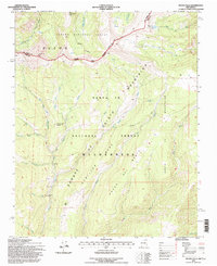
 1995 Cerro Vista1997 Print · USGSThe Sangre de Cristo Mountains during the mid-nineties reveal a landscape shaped by historic land grants and forestry. Local historians can trace the boundaries of the Rancho del Rio Grande Grant and locate places like Little Korea and Chacon.
 - 1995 Map of Shady Brook, 1997 Print
 1995 Shady Brook1997 Print · USGSThe high Sangre de Cristo Mountains of the mid-nineties are mapped here across the Rancho del Rio Grande Grant. Trace local development in Shady Brook and Valle Escondido, or locate water sources like Bernardin Lake and Porky Spring.
 - 1995 Map of Chacon, 1997 Print
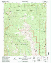
 1995 Chacon1997 Print · USGSThe Sangre de Cristo Mountains in the mid-1990s reveal a landscape of deep canyons and high mountain forest surrounding the Mora Grant. Researchers can trace ancestral sites at San Antonio Cem, explore the headwaters of the Mora River, or map the remote reaches of Lujan Canyon.
 - 1995 Map of Osha Mountain, 1997 Print
 1995 Osha Mountain1997 Print · USGSThe high peaks and land grants of northern New Mexico are captured here in the mid-1990s as the borders of three counties meet. Genealogists and local historians can trace legacy sites like the San Antonio Ch Cem or navigate the high reaches of Osha Mountain and Valle Largo.
 - 1995 Map of Truchas Peak, 1997 Print
 1995 Truchas Peak1997 Print · USGSThe high peaks of the Sangre de Cristo Mountains are captured here in the mid-1990s, where three national forests and several county lines converge. Hikers and historians can trace the high-altitude Trailriders Wall, locate Pecos Falls, or find the secluded Jose Vigil Lake.
 - 1995 Map of Jicarita Peak, 1997 Print
 1995 Jicarita Peak1997 Print · USGSThe high Sangre de Cristo Mountains of the mid-1990s are mapped here as they straddle three New Mexico counties. Trace high-altitude landmarks and alpine water sources including Jicarita Peak, Serpent Lake, and the historic trails of the Santa Barbara Grant.
 - 1995 Map of Pecos Falls, 1997 Print
 1995 Pecos Falls1997 Print · USGSThe high alpine wilderness of the Sangre de Cristo Mountains comes into focus in the mid-nineties. Trace historic routes like Camino Real Rd, find the remote Pecos Falls, or locate peaks such as Chimayosos Peak and Little Jicarita Peak.
 - 1995 Map of Holman, 1998 Print
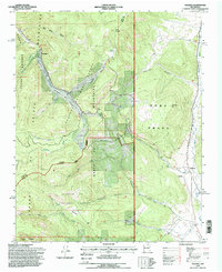 1995 Holman1998 Print · USGSNorthern New Mexico's high mountain valleys are documented here in the mid-nineties, showing the intersection of Spanish land grants and national forests. Genealogists and historians can locate the Agua Negra Cemetery near Holman or trace old water rights along the Sierra Ditch and La Sierra Ditch.
 - 1998 Map of Canon Colorado, 2001 Print
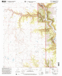 1998 Canon Colorado2001 Print · USGSThe high plains and deep canyonlands of Mora County are captured in the late nineties, showcasing the remote terrain of the Kiowa National Grassland. Researchers can locate the Paises Cem and the settlement of Adobe while tracing the winding path of the Canadian River.
 - 1998 Map of Jaritas Ranch, 2001 Print
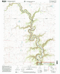 1998 Jaritas Ranch2001 Print · USGSThe high plains of Mora County met the deep breaks of the Canadian River at the end of the twentieth century. Genealogists and historians can trace family land ties near Jaritas Ranch or explore the drainage networks of Dog Canyon and Lodge Canyon.
 - 1998 Map of Beaver Canyon, 2001 Print
 1998 Beaver Canyon2001 Print · USGSThe Canadian River gorge cuts through the high plains of Harding and Mora counties in the late nineties. Genealogists and local historians can trace isolated landmarks like a riverside Cem and the rugged drainage systems of Beaver Canyon and Cañon Blanco.
 - 1998 Map of Mills West, 2001 Print
 1998 Mills West2001 Print · USGSHarding County’s high plains and deep canyons are documented here in the late nineties, showcasing a remote ranching landscape. You can locate the Mesteñito Cem and trace the settlement at Mills alongside the dramatic breaks of the Canadian River.
End of results
Showing maps 1-19 of 19
Top cities of Mora County
Frequently asked questions
- What are the different types of historical maps available for Mora County?
- What is the oldest map of Mora County?
- Where can I purchase historical maps of Mora County for my home or office?
- Where can I download high-res historical maps of Mora County?
- Are there historical topographic maps available for Mora County?
- Is there historical aerial imagery available for Mora County?
- Where are historical maps of Mora County sourced from?