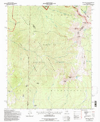
1995 Map of Truchas Peak
USGS Topo · Published 1997About this map
The Sangre de Cristo Mountains define this high-altitude landscape where the Pecos Wilderness meets the Carson National Forest and Santa Fe National Forest. Dominating the northeast corner is the massive uplift of Truchas Peak, flanked by North Truchas Peak and Middle Truchas Peak, forming a high ridgeline that separates the drainage of the Rio Mora from the North Fork Rio Quemado. These peaks, some of the highest in the state, overlook alpine basins holding Trampas Lake, Truchas Lakes, and Jose Vigil Lake.
Find a feature on this map
39 named features on this map. Tap any name to fly to it.
Don’t see what you’re looking for? This feature index may not catch every label — zoom into the map to look around manually.
Map Details
Editions of this 1995 Truchas Peak Map
This is the sole edition of this map. No revisions or reprints were ever made.
Other maps of this area

1889 · Santa Fe
USGS Topo · 1:125,000

1894 · Santa Fe
USGS Topo · 1:125,000

1953 · Truchas
USGS Topo · 1:24,000

1953 · Sierra Mosca
USGS Topo · 1:24,000

1953 · Aspen Basin
USGS Topo · 1:24,000

1954 · Santa Fe
USGS Topo · 1:250,000

1954 · Raton
USGS Topo · 1:250,000

1958 · Raton
USGS Topo · 1:250,000

1958 · Santa Fe
USGS Topo · 1:250,000
1961 · Cowles
USGS Topo · 1:24,000