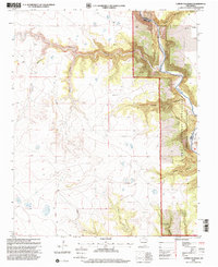
1998 Map of Canon Colorado
USGS Topo · Published 2001About this map
Kiowa National Grassland dominates the eastern half of this landscape, where the Canadian River cuts a deep course through the high plains of northeastern New Mexico. This 1998 revision by the Forest Service highlights a rugged drainage system where numerous canyons, such as Cañon Colorado and Cañon Hondo, converge toward the river valley. The map reveals a sparsely populated ranching and grazing environment, punctuated by the small settlement of Adobe and the isolated Paises Cem.
Find a feature on this map
28 named features on this map. Tap any name to fly to it.
Don’t see what you’re looking for? This feature index may not catch every label — zoom into the map to look around manually.
Map Details
Editions of this 1998 Canon Colorado Map
This is the sole edition of this map. No revisions or reprints were ever made.
Other maps of this area

1892 · Watrous
USGS Topo · 1:125,000

1894 · Watrous
USGS Topo · 1:125,000

1954 · Santa Fe
USGS Topo · 1:250,000

1954 · Raton
USGS Topo · 1:250,000

1958 · Raton
USGS Topo · 1:250,000

1958 · Santa Fe
USGS Topo · 1:250,000

1964 · Stony Lake
USGS Topo · 1:24,000

1964 · Alto De Hormiga
USGS Topo · 1:24,000

1964 · Alamosa Creek
USGS Topo · 1:24,000

1971 · Abbott Lake
USGS Topo · 1:24,000