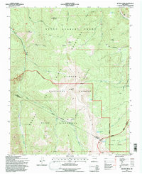
1995 Map of Jicarita Peak
USGS Topo · Published 1997About this map
Jicarita Peak rises as the central landmark of this high-elevation landscape within the Sangre de Cristo Mountains, where the boundaries of Taos, Rio Arriba, and Mora counties converge. The terrain is defined by the sharp transition between the Carson National Forest and the Pecos Wilderness, a region marked by high alpine lakes and glacial cirques. Water sources like Serpent Lake, Horseshoe Lake, and North Fork Lake feed the headwaters of the Rio Santa Barbara, which flows northward through the Santa Barbara Grant. Historically significant transit is evidenced by a network of high-country routes including the Comales Trail and the West Fork Angostura Trail, providing access to peaks such as Peñascoso Mountain and Bear Mountain. The map details a sophisticated hydrological system, including the Rio Pueblo and the Rio Alamitos, that has sustained this high-altitude livestock and timber region for generations.
Find a feature on this map
39 named features on this map. Tap any name to fly to it.
Don’t see what you’re looking for? This feature index may not catch every label — zoom into the map to look around manually.
Map Details
Editions of this 1995 Jicarita Peak Map
This is the sole edition of this map. No revisions or reprints were ever made.
Other maps of this area

1889 · Las Vegas
USGS Topo · 1:125,000

1889 · Santa Fe
USGS Topo · 1:125,000

1891 · Las Vegas
USGS Topo · 1:125,000

1893 · Las Vegas
USGS Topo · 1:125,000

1894 · Santa Fe
USGS Topo · 1:125,000

1954 · Santa Fe
USGS Topo · 1:250,000

1954 · Raton
USGS Topo · 1:250,000

1958 · Raton
USGS Topo · 1:250,000

1958 · Santa Fe
USGS Topo · 1:250,000
1963 · Truchas Peak
USGS Topo · 1:24,000