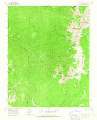
1963 Map of Truchas Peak
USGS Topo · Published 1965About this map
North Truchas Peak and Middle Truchas Peak crown this high-elevation landscape where the boundaries of Santa Fe, Rio Arriba, and Mora counties meet. The 1963 field survey documents a wilderness of alpine lakes and dramatic ridgelines, including the Trailriders Wall and Pecos Baldy. Human presence is marked primarily by isolated structures like Brazas Cabin and the Panchuela West Cabin, connected by an extensive network of pack trails. These routes navigate the drainage basins of the North Fork Rio Quemado and Rio Medio, providing access to high-country basins such as Horsethief Meadow. The map also captures the intersection of the Santa Fe National Forest and Carson National Forest, alongside the northern edge of the Nuestra Senora Del Rosario San Fernando Y Santiago Grant Bdy.
Find a feature on this map
36 named features on this map. Tap any name to fly to it.
Don’t see what you’re looking for? This feature index may not catch every label — zoom into the map to look around manually.
Map Details
Editions of this 1963 Truchas Peak Map
2 editions found
Other maps of this area

1889 · Santa Fe
USGS Topo · 1:125,000

1894 · Santa Fe
USGS Topo · 1:125,000

1953 · Truchas
USGS Topo · 1:24,000

1953 · Sierra Mosca
USGS Topo · 1:24,000

1953 · Aspen Basin
USGS Topo · 1:24,000

1954 · Santa Fe
USGS Topo · 1:250,000

1954 · Raton
USGS Topo · 1:250,000

1958 · Raton
USGS Topo · 1:250,000

1958 · Santa Fe
USGS Topo · 1:250,000
1961 · Cowles
USGS Topo · 1:24,000