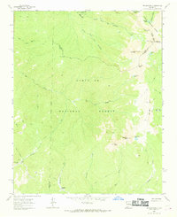
1963 Map of Truchas Peak
USGS Topo · Published 1969About this map
Truchas Peak and its surrounding summits dominate this high-elevation mountain landscape where the boundaries of Santa Fe National Forest and Carson National Forest meet. The geography is defined by a series of prominent peaks, including Middle Truchas Peak and North Truchas Peak, alongside the sharp relief of Pecos Baldy and East Pecos Baldy. These alpine heights overlook a complex drainage system where the North Fork Rio Quemado and South Fork Rio Quemado originate.
Find a feature on this map
38 named features on this map. Tap any name to fly to it.
Don’t see what you’re looking for? This feature index may not catch every label — zoom into the map to look around manually.
Map Details
Editions of this 1963 Truchas Peak Map
2 editions found
Other maps of this area

1889 · Santa Fe
USGS Topo · 1:125,000

1894 · Santa Fe
USGS Topo · 1:125,000

1953 · Truchas
USGS Topo · 1:24,000

1953 · Sierra Mosca
USGS Topo · 1:24,000

1953 · Aspen Basin
USGS Topo · 1:24,000

1954 · Santa Fe
USGS Topo · 1:250,000

1954 · Raton
USGS Topo · 1:250,000

1958 · Raton
USGS Topo · 1:250,000

1958 · Santa Fe
USGS Topo · 1:250,000
1961 · Cowles
USGS Topo · 1:24,000