1970s Maps of Mora County, New Mexico
Explore 7 historic maps of Mora County from the 1970s. These maps offer a rare glimpse into what life looked like during the 1970s — showing old roads, neighborhoods, homes, and landmarks that have changed or disappeared over time.
Whether you're researching your family's past, planning a metal detecting trip, or studying how Mora County's landscape evolved across the 1970s, these high-resolution maps are a powerful tool for exploring the history of this region.
- Focus on a specific era: All maps on this page are from the 1970s, giving you a focused view of this time period.
- See what’s changed: Compare century-old streets, trails, and buildings to today's modern landscape using overlays and satellite layers.
- Research with precision: Use these maps for genealogy, historical research, land use analysis, or educational projects.
- View, download, or print: Maps are fully viewable online in high resolution, and can be downloaded or printed for your own records.
Start exploring Mora County's history through authentic maps from the 1970s. This is your window into the past.
Mora County, NM maps
(7)- 1971 Map of Beaver Canyon, 1975 Print
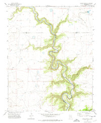
 1971 Beaver Canyon1975 Print · USGSThe Canadian River breaks across the high plains of Harding and Mora counties in the early 1970s. Trace old Jeep Trails and remote landmarks like the Cem and Upper Horseshoe Bend as they appeared before modern development.
 - 1971 Map of Alamito, 1975 Print
 1971 Alamito1975 Print · USGSNortheastern New Mexico ranchlands meet the deep river breaks of the High Plains in the early seventies. Genealogists and local historians can trace family-named landmarks like Cañon de los Nieves and Banco Redondo near the remote settlement of Alamito.
 - 1971 Map of Canon Las Cuevas, 1975 Print
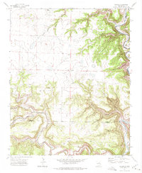
 1971 Canon Las Cuevas1975 Print · USGSMora County ranching country is documented here in the early seventies, showcasing a landscape of deep canyons and high mesas. Genealogists and historians can locate isolated landmarks like the Thompson Windmill, a solitary Grave, and the winding Mills Canyon Road.
 - 1971 Map of Canon Encierro, 1975 Print
 1971 Canon Encierro1975 Print · USGSThe high canyon country of northeastern New Mexico is captured here in the early seventies, showing a landscape defined by the winding Canadian River. Researchers can locate isolated burial sites like Armenta Plaza Cem and trace old family landforms such as Valle Romero.
 - 1972 Map of Canon Colorado, 1975 Print
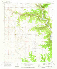 1972 Canon Colorado1975 Print · USGSThe high plains of Mora County meet the deep canyons of the Canadian River in the early 1970s. Researchers can locate the Paises Cem and trace the remote routes of Mills Canyon Road near the Adobe and Monett settlements.
 - 1972 Map of Jaritas Ranch, 1975 Print
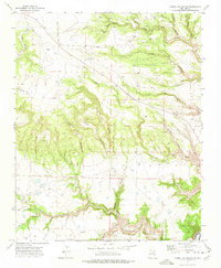
 1972 Jaritas Ranch1975 Print · USGSRanching life in northeastern New Mexico during the early seventies centers on the deep canyons of the Canadian River. Genealogists and historians can trace the Old Railroad Grade and remote landmarks like Jaritas Ranch and Dog Canyon.
 - 1972 Map of Mills West, 1975 Print
 1972 Mills West1975 Print · USGSHarding County ranchlands and the deep breaks of the Canadian River define this area during the early seventies. Genealogists and local historians can trace the Old Railroad Grade past Mills or locate the remote Mesteñito Cem.
End of results
Showing maps 1-7 of 7
Top cities of Mora County
Frequently asked questions
- What are the different types of historical maps available for Mora County?
- What is the oldest map of Mora County?
- Where can I purchase historical maps of Mora County for my home or office?
- Where can I download high-res historical maps of Mora County?
- Are there historical topographic maps available for Mora County?
- Is there historical aerial imagery available for Mora County?
- Where are historical maps of Mora County sourced from?