1990s Maps of Valencia County, New Mexico
Explore 22 historic maps of Valencia County from the 1990s. These maps offer a rare glimpse into what life looked like during the 1990s — showing old roads, neighborhoods, homes, and landmarks that have changed or disappeared over time.
Whether you're researching your family's past, planning a metal detecting trip, or studying how Valencia County's landscape evolved across the 1990s, these high-resolution maps are a powerful tool for exploring the history of this region.
- Focus on a specific era: All maps on this page are from the 1990s, giving you a focused view of this time period.
- See what’s changed: Compare century-old streets, trails, and buildings to today's modern landscape using overlays and satellite layers.
- Research with precision: Use these maps for genealogy, historical research, land use analysis, or educational projects.
- View, download, or print: Maps are fully viewable online in high resolution, and can be downloaded or printed for your own records.
Start exploring Valencia County's history through authentic maps from the 1990s. This is your window into the past.
Valencia County, NM maps
(22)- 1991 Map of Mount Washington, 1995 Print
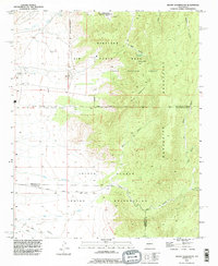 1991 Mount Washington1995 Print · USGSThe high desert south of Albuquerque in the early nineties reveals a landscape of restricted military lands and tribal territory. Researchers can trace the boundaries of the Kirtland Air Force Base alongside the peaks of the Manzanita Mountains and the remote Mines of Hells Canyon.
 - 1991 Map of Veguita, 1996 Print
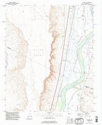 1991 Veguita1996 Print · USGSThe Rio Grande valley in central New Mexico appears here as a complex patchwork of historic land grants and irrigation networks in the mid-twentieth century. Researchers can trace the water systems of the Old Jarales Ditch and locate family-named settlements like Jarales, Bosque, and Sabinal.
 - 1991 Map of Dalies, 1996 Print
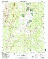
 1991 Dalies1996 Print · USGSThe High Desert of Valencia County in the early nineties reveals a landscape of historic land grants and volcanic heights. Researchers can trace the rail junction at Dalies and explore the complex water systems of the Belen Highline Canal near Los Lunas.2 unique versions available
 - 1991 Map of Rio Puerco, 1996 Print
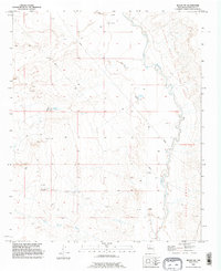
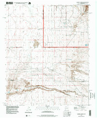
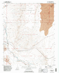 1991 Rio Puerco1996 Print · USGSThe high desert along the Rio Puerco reveals a landscape of massive historical land grants in the early nineties. Researchers can trace the overlapping boundaries of the San Clemente Grant and Pueblo of Isleta Grant near Hidden Mountain.
 - 1991 Map of Tome, 1996 Print
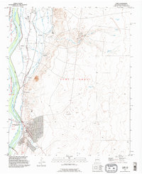 1991 Tome1996 Print · USGSThe Rio Grande valley near Belen appears in the early 1990s as a landscape of historic land grants and vital irrigation systems. Researchers can trace the layout of traditional settlements like Tome and Adelino alongside the Tome Ditch and Tome Cemetery.
 - 1991 Map of Bosque Peak, 1996 Print
 1991 Bosque Peak1996 Print · USGSThe high peaks of Torrance County are captured here in the early 1990s as the wilderness boundary meets ancient land grants. Researchers can trace historic access routes like the Sandia Trail and locate isolated water sources such as Fourth Of July Spring and Lolito Spring.
 - 1991 Map of Tome NE, 1996 Print
 1991 Tome NE1996 Print · USGSValencia County’s high-desert foothills are captured here in the early nineties, where the Tome Grant meets the Manzano Mountains. Local history researchers can trace vital water sources like Ojo Jedeonilla and Ojo Lemita across the arid terrain.
 - 1991 Map of Isleta, 1996 Print
 1991 Isleta1996 Print · USGSThe Rio Grande valley south of Albuquerque is documented here in the early nineties, showing the interface between tribal lands and rural settlements. Researchers can trace ancestral locations near Isleta Pueblo, Los Padillas, and the Pajarito Cemetery.
 - 1991 Map of Tome SE, 1996 Print
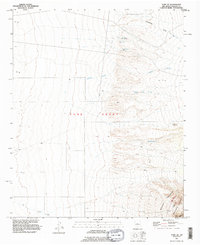
 1991 Tome SE1996 Print · USGSHistoric land grant boundaries and mountain terrain intersect in Valencia County in the early 1990s. Researchers can trace the massive Tome Grant limits and locate remote water sources like North Well and Mountain Well near the Manzano Mountains.
 - 1991 Map of Los Lunas, 1996 Print
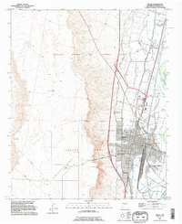
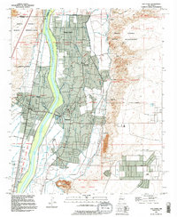 1991 Los Lunas1996 Print · USGSThe Rio Grande valley in the early nineties reveals a complex landscape of ancestral land grants and modern irrigation. Researchers can trace historic property lines like the Tome Grant or find family sites at Los Lentes Cem and El Camposanto de la Liverte.
 - 1991 Map of Turn, 1996 Print
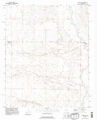
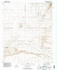
 1991 Turn1996 Print · USGSValencia County at the end of the twentieth century shows a landscape shaped by ancient land grants and early aviation. Genealogists can trace the rural communities of Turn and Madrone while locating the small Cem near the Sabinal Ditch.
 - 1991 Map of Belen SW, 1996 Print
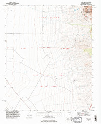
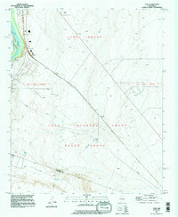
 1991 Belen SW1996 Print · USGSSocorro County's arid drainages and land grants are documented here in the early 1990s. Researchers can trace the path of the Rio Puerco and locate survey markers along the New Mexico Principal Meridian and Belen Grant.
 - 1991 Map of Los Lunas SE, 1996 Print
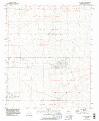 1991 Los Lunas SE1996 Print · USGSValencia County is shown in the early 1990s as a landscape defined by historic Spanish land grants and indigenous territory. Researchers can trace the boundaries of the Lo De Padilla Grant and the Tome Grant or locate natural water sources like Maes Spring.
 - 1991 Map of Belen, 1996 Print
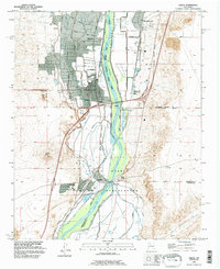
 1991 Belen1996 Print · USGSBelen and the Rio Grande valley are seen here in the early nineties, showing a landscape shaped by historical land grants and vital irrigation works. Genealogists can trace family names and local landmarks through sites like Our Lady of Belen Cem, Bacaville, and the Tome Grant.
 - 1991 Map of Belen NW, 1996 Print
 1991 Belen NW1996 Print · USGSValencia County’s high desert landscape comes into focus in the 1990s, where historical land grants meet the winding Rio Puerco. Researchers can trace the bounds of the Nicolas Duran de Chavez Grant or locate ranching outposts like the Shearing Corral and Popalito Windmill.
 - 1991 Map of Hubbell Spring, 1996 Print
 1991 Hubbell Spring1996 Print · USGSThe high desert south of Albuquerque transitioned from ranching to military and indigenous land management by the early 1990s. Researchers can trace the boundaries of the Isleta Pueblo Indian Reservation and locate local landmarks like Hubbell Spring or the McCormick Ranch.
 - 1995 Map of Capilla Peak, 1998 Print
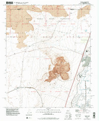
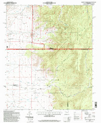
 1995 Capilla Peak1998 Print · USGSThe high Manzano Mountains of Torrance County are captured here in the mid-1990s, revealing a landscape of remote peaks and protected wilderness. Researchers can trace historical land grants and high-altitude water sources like Ojo la Casa, the Capilla Peak Observatory, and the settlement at Aguayo.
 - 1995 Map of Manzano Peak, 1998 Print
 1995 Manzano Peak1998 Print · USGSThe Manzano Mountains and the high desert of the 1990s are defined here by old land grants and isolated water sources. Genealogists and historians can trace boundaries of the Tome Grant or locate landmarks like Kayser Mill and Rattlesnake Spring.
 - 1995 Map of Mount Washington, 1998 Print
 1995 Mount Washington1998 Print · USGSThe Manzanita Mountains in the mid-1990s show a rugged intersection of military operations and indigenous lands. Researchers can trace the complex boundaries of Kirtland Air Force Base alongside the Pueblo of Isleta Grant and the Manzano Lookout.
 - 1995 Map of Scholle, 1998 Print
 1995 Scholle1998 Print · USGSSocorro County and the tri-county borderlands come to life in the mid-1990s as a high-desert ranching and mining hub. Genealogists and historians can trace the local economy through Scholle Siding, the Abo Mine, and family landmarks like the Casa Colorada Grant.
 - 1995 Map of Bosque Peak, 1998 Print
 1995 Bosque Peak1998 Print · USGSThe high country of Torrance County is captured here in the mid-1990s, where traditional land grants meet protected wilderness. Trace the intersection of the Isleta Pueblo Grant and Tome Grant or locate mountain water sources like Lolito Spring and Garcia Spring.
 - 1996 Map of Hubbell Spring, 1999 Print
 1996 Hubbell Spring1999 Print · USGSThe high desert south of Albuquerque in the mid-1990s reveals a landscape defined by tribal lands and military infrastructure. Researchers can trace the boundaries of Kirtland Air Force Base alongside local landmarks like McCormick Ranch and Hubbell Spring.
End of results
Showing maps 1-22 of 22
Top cities of Valencia County
- Los Lunas historical maps
- Belen historical maps
- Rio Communities historical maps
- Bosque Farms historical maps
- Peralta historical maps
Frequently asked questions
- What are the different types of historical maps available for Valencia County?
- What is the oldest map of Valencia County?
- Where can I purchase historical maps of Valencia County for my home or office?
- Where can I download high-res historical maps of Valencia County?
- Are there historical topographic maps available for Valencia County?
- Is there historical aerial imagery available for Valencia County?
- Where are historical maps of Valencia County sourced from?