1900-1909 Maps of Cattaraugus County, New York
Explore 8 historic maps of Cattaraugus County from 1900-1909. These maps offer a rare glimpse into what life looked like during the 1900s — showing old roads, neighborhoods, homes, and landmarks that have changed or disappeared over time.
Whether you're researching your family's past, planning a metal detecting trip, or studying how Cattaraugus County's landscape evolved across the 1900s, these high-resolution maps are a powerful tool for exploring the history of this region.
- Focus on a specific era: All maps on this page are from the 1900s, giving you a focused view of this time period.
- See what’s changed: Compare century-old streets, trails, and buildings to today's modern landscape using overlays and satellite layers.
- Research with precision: Use these maps for genealogy, historical research, land use analysis, or educational projects.
- View, download, or print: Maps are fully viewable online in high resolution, and can be downloaded or printed for your own records.
Start exploring Cattaraugus County's history through authentic maps from the 1900s. This is your window into the past.
Cattaraugus County, NY maps
(8)- 1900 Map of Cherry Creek
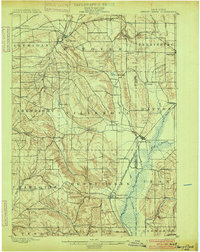 1900 Cherry Creek1900 Print · USGSWestern New York near the turn of the century shows a landscape of developing rail hubs and managed wetlands. Genealogists can trace family roots through settlements like Forestville, South Dayton, and Leon, or locate vanished stations like Smiths Mills Sta. and the rural crossroads at Charlotte Center.6 unique versions available
 - 1900 Map of Salamanca
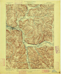 1900 Salamanca1900 Print · USGSCattaraugus County's rail and timber era is documented here as it appeared in the late 1890s, centered on the river-bend hub of Salamanca. Genealogists and historians can trace the early boundaries of the Allegheny Indian Reservation and locate vanished rail stops like Irvine Mills and Peth.6 unique versions available
 - 1905 Map of Jamestown
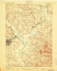 1905 Jamestown1905 Print · USGSJamestown and the surrounding Chautauqua County valleys are captured here at the start of the twentieth century. Researchers can trace early rail corridors like the Erie R.R. and locate family-named landmarks in Frewsburg, Ellington, and Kiantone.5 unique versions available
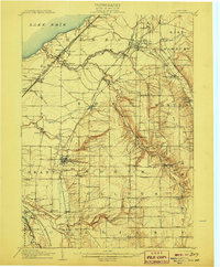
 - 1905 Map of Eden, 1961 Print
 1905 Eden1961 Print · USGSWestern New York at the turn of the century reveals a landscape of growing rail towns and lakefront retreats. Genealogists can trace family roots in North Collins or follow the early tracks of the Lake Shore and Michigan Southern.
 - 1906 Map of Warren
 1906 Warren1906 Print · USGSWarren and its surrounding river valleys are captured here at the height of the early rail era. Genealogists can trace family names across dozens of rural landmarks, from the State Insane Asylum to scattered outposts like Lander and Old Clarendon.3 unique versions available
 - 1907 Map of Warren
 1907 Warren1907 Print · USGSWarren and its riverfront neighborhoods thrived at the dawn of the century as a hub for the Pennsylvania RR. Local historians can trace the footprint of the State Insane Asylum and find rural schools such as Dutch Hill School and Knupp School.
 - 1907 Map of Eden
 1907 Eden1907 Print · USGSSouthern Erie County at the turn of the century reveals a landscape of growing towns and busy rail lines carving through deep creek valleys. Genealogists and historians can trace family locations in North Collins, Eden Valley, and the Cattaraugus Indian Reservation.4 unique versions available
 - 1908 Map of Warren
 1908 Warren1908 Print · USGSThe river-and-rail economy of Warren County is documented here at the turn of the century. Genealogists can trace family-named landmarks and rural hubs like Lander, Oakland Cem, and the State Insane Asylum.3 unique versions available
End of results
Showing maps 1-8 of 8
Top cities of Cattaraugus County
- Olean historical maps
- Allegany historical maps
- Salamanca historical maps
- Yorkshire historical maps
- Portville historical maps
- Franklinville historical maps
See more
Frequently asked questions
- What are the different types of historical maps available for Cattaraugus County?
- What is the oldest map of Cattaraugus County?
- Where can I purchase historical maps of Cattaraugus County for my home or office?
- Where can I download high-res historical maps of Cattaraugus County?
- Are there historical topographic maps available for Cattaraugus County?
- Is there historical aerial imagery available for Cattaraugus County?
- Where are historical maps of Cattaraugus County sourced from?