1950s Maps of Cattaraugus County, New York
Explore 10 historic maps of Cattaraugus County from the 1950s. These maps offer a rare glimpse into what life looked like during the 1950s — showing old roads, neighborhoods, homes, and landmarks that have changed or disappeared over time.
Whether you're researching your family's past, planning a metal detecting trip, or studying how Cattaraugus County's landscape evolved across the 1950s, these high-resolution maps are a powerful tool for exploring the history of this region.
- Focus on a specific era: All maps on this page are from the 1950s, giving you a focused view of this time period.
- See what’s changed: Compare century-old streets, trails, and buildings to today's modern landscape using overlays and satellite layers.
- Research with precision: Use these maps for genealogy, historical research, land use analysis, or educational projects.
- View, download, or print: Maps are fully viewable online in high resolution, and can be downloaded or printed for your own records.
Start exploring Cattaraugus County's history through authentic maps from the 1950s. This is your window into the past.
Cattaraugus County, NY maps
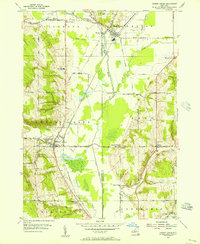
(10)- 1954 Map of Kennedy, 1955 Print
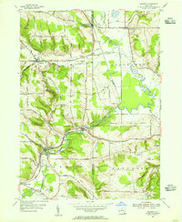 1954 Kennedy1955 Print · USGSThe Chautauqua and Cattaraugus county line comes alive in the mid-fifties, showing a landscape shaped by the Erie RR and Conewango Creek. Researchers can trace ancestral locations like Schermerhorn Corners, Poland Center, and several old burial grounds including Pioneer Cem.3 unique versions available
 - 1954 Map of Springville, 1955 Print
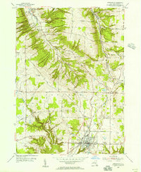 1954 Springville1955 Print · USGSSouthern Erie County in the mid-fifties is defined by the thriving village of Springville and the winding course of the Baltimore and Ohio railroad. Local historians can trace early schools and healthcare sites like Griffith Institute and Chaffee Hosp, or locate family plots at Maplewood Cem and Sibley Cem.2 unique versions available
 - 1954 Map of Scandia, 1956 Print
 1954 Scandia1956 Print · USGSThe Pennsylvania and New York borderlands come alive in this midcentury survey of the hills north of Warren. Local historians can trace the foundations of Scandia, find family plots at Seven Dolors Cem, and locate the sprawling grounds of the Warren State Hospital.3 unique versions available
 - 1954 Map of Ivory, 1956 Print
 1954 Ivory1956 Print · USGSThe rural borderlands between Chautauqua and Cattaraugus Counties are captured here in the mid-1950s. Genealogists can trace family footprints through sites like Oak Hill Cem, Wheeler Hill Ch, and the small settlement of Ivory.4 unique versions available
 - 1954 Map of Cherry Creek, 1956 Print
 1954 Cherry Creek1956 Print · USGSMid-century Chautauqua and Cattaraugus Counties are captured here just as the rural school system and railroad economy were consolidating. Researchers can locate family landmarks at Kings School Corner, trace the Erie RR through South Dayton, or find the Union Cem near Leon.3 unique versions available
 - 1954 Map of Perrysburg, 1956 Print
 1954 Perrysburg1956 Print · USGSChautauqua County in the mid-fifties is seen here through its network of small hamlets and the critical Erie RR line. Genealogists can trace family names through landmarks like Wrights Corners, Villenova Cem, and School No 1.4 unique versions available
 - 1957 Map of Sardinia, 1958 Print
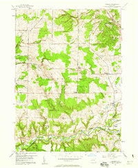 1957 Sardinia1958 Print · USGSSoutheastern Erie County in the late fifties was a landscape of high ridges and rural family crossroads. Genealogists and researchers can trace the old rail lines of the Pennsylvania Railroad and locate vanished landmarks like Tru-Blue Ch and Sillimans Corners.3 unique versions available
 - 1957 Map of Warren, 1964 Print
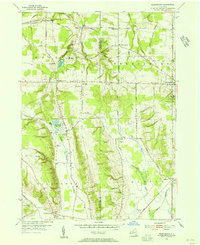
 1957 Warren1964 Print · USGSThe northern Pennsylvania oil and timber country comes into focus in the mid-fifties, showing the region before modern highway expansions. Trace the industrial rail networks of the Pennsylvania RR and the early Allegheny River Reservoir near Warren and Oil City.4 unique versions available
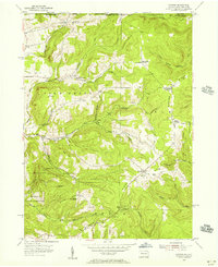
 - 1958 Map of Warren
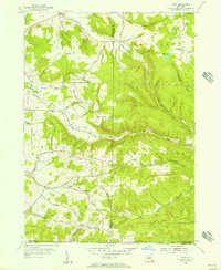
 1958 Warren1958 Print · USGSNorthern Pennsylvania’s timber and oil country is captured here during the late fifties, showing the interplay of industrial valleys and vast state forests. Genealogists can trace family connections across the Cornplanter Indian Reservation or through rail hubs like Oil City and Saint Marys.
 - 1959 Map of Warren
 1959 Warren1959 Print · USGSNorthern Pennsylvania's oil and timber country comes alive in this late-fifties study of the forest-clad plateaus. Trace the historic Cornplanter (Indian Reservation), the sprawling Oil Field, and the rail lines of the Pennsylvania RR.2 unique versions available
End of results
Showing maps 1-10 of 10
Top cities of Cattaraugus County
- Olean historical maps
- Allegany historical maps
- Salamanca historical maps
- Yorkshire historical maps
- Portville historical maps
- Franklinville historical maps
See more
Frequently asked questions
- What are the different types of historical maps available for Cattaraugus County?
- What is the oldest map of Cattaraugus County?
- Where can I purchase historical maps of Cattaraugus County for my home or office?
- Where can I download high-res historical maps of Cattaraugus County?
- Are there historical topographic maps available for Cattaraugus County?
- Is there historical aerial imagery available for Cattaraugus County?
- Where are historical maps of Cattaraugus County sourced from?