Old Maps of Cattaraugus County, New York for Academic Research
Study the evolution of Cattaraugus County with 277 high-resolution historic maps. Whether you're teaching, researching, or modeling changes in land use, these maps provide essential visual documentation of urban, environmental, and geographic change.
- Analyze long-term change: Track patterns in development, transportation, and natural features.
- Ideal for environmental or urban studies: Support academic projects with primary historical map data.
- Use in the classroom or lab: Educators and researchers rely on these maps to bring historical context to life.
These maps are a powerful tool for teaching, research, and visualizing how Cattaraugus County has changed over the decades.
Cattaraugus County, NY maps
(277)- 1898 Map of Olean
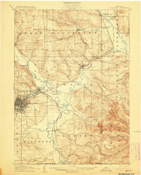
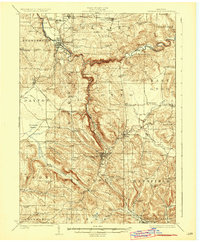
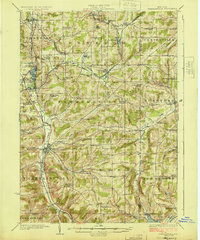
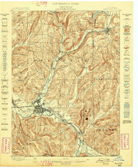 1898 Olean1898 Print · USGSCattaraugus County is shown here at the peak of its rail-and-river era, centered on the major industrial junction at Olean. Genealogists and collectors can trace the sprawling network of the Penna. R.R. and locate vanished local landmarks like the Oil Tanks or the distinct formation at Rock City.5 unique versions available
 - 1899 Map of Silver Creek
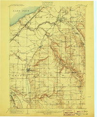
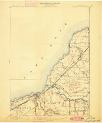 1899 Silver Creek1899 Print · USGSThe Lake Erie shoreline and its industrial rail corridors are captured here at the close of the nineteenth century. Researchers can trace the early layout of Angola and Silver Creek or locate landmarks within the Cattaraugus Indian Reservation.7 unique versions available
 - 1900 Map of Cherry Creek
 1900 Cherry Creek1900 Print · USGSWestern New York near the turn of the century shows a landscape of developing rail hubs and managed wetlands. Genealogists can trace family roots through settlements like Forestville, South Dayton, and Leon, or locate vanished stations like Smiths Mills Sta. and the rural crossroads at Charlotte Center.6 unique versions available
 - 1900 Map of Salamanca
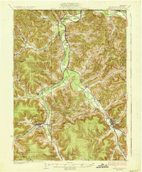
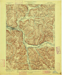 1900 Salamanca1900 Print · USGSCattaraugus County's rail and timber era is documented here as it appeared in the late 1890s, centered on the river-bend hub of Salamanca. Genealogists and historians can trace the early boundaries of the Allegheny Indian Reservation and locate vanished rail stops like Irvine Mills and Peth.6 unique versions available
 - 1905 Map of Jamestown
 1905 Jamestown1905 Print · USGSJamestown and the surrounding Chautauqua County valleys are captured here at the start of the twentieth century. Researchers can trace early rail corridors like the Erie R.R. and locate family-named landmarks in Frewsburg, Ellington, and Kiantone.5 unique versions available
 - 1905 Map of Eden, 1961 Print
 1905 Eden1961 Print · USGSWestern New York at the turn of the century reveals a landscape of growing rail towns and lakefront retreats. Genealogists can trace family roots in North Collins or follow the early tracks of the Lake Shore and Michigan Southern.
 - 1906 Map of Warren
 1906 Warren1906 Print · USGSWarren and its surrounding river valleys are captured here at the height of the early rail era. Genealogists can trace family names across dozens of rural landmarks, from the State Insane Asylum to scattered outposts like Lander and Old Clarendon.3 unique versions available
 - 1907 Map of Warren
 1907 Warren1907 Print · USGSWarren and its riverfront neighborhoods thrived at the dawn of the century as a hub for the Pennsylvania RR. Local historians can trace the footprint of the State Insane Asylum and find rural schools such as Dutch Hill School and Knupp School.
 - 1907 Map of Eden
 1907 Eden1907 Print · USGSSouthern Erie County at the turn of the century reveals a landscape of growing towns and busy rail lines carving through deep creek valleys. Genealogists and historians can trace family locations in North Collins, Eden Valley, and the Cattaraugus Indian Reservation.4 unique versions available
 - 1908 Map of Warren
 1908 Warren1908 Print · USGSThe river-and-rail economy of Warren County is documented here at the turn of the century. Genealogists can trace family-named landmarks and rural hubs like Lander, Oakland Cem, and the State Insane Asylum.3 unique versions available
 - 1922 Map of Randolph, 1955 Print
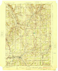
 1922 Randolph1955 Print · USGSCattaraugus County in the early twenties shows a landscape of river-valley commerce and mountain parkland. Genealogists can locate dozens of country schoolhouses like Archer Hill School and vanished rail stops such as Onoville Sta and Elkdale Sta.2 unique versions available
 - 1923 Map of Randolph
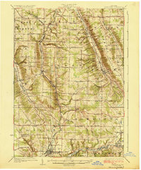
 1923 Randolph1923 Print · USGSCattaraugus County's southern borderlands are captured here in the early 1920s, showing a landscape defined by the winding Allegheny River and burgeoning state park. Genealogists can trace family footprints at the Wolf Run Elko PO, Oldtown School, or the many rural schoolhouses like Bunker Hill School.4 unique versions available
 - 1923 Map of Cattaraugus
 1923 Cattaraugus1923 Print · USGSWestern New York's rugged hill country is captured here during the early twenties, showing a landscape defined by deep creek valleys and a dense network of country schools. Genealogists can trace family locations near landmarks like the State Asylum, Judd Corners, or the dozens of rural schoolhouses such as Rosenburg School.4 unique versions available
 - 1923 Map of Arcade, 1957 Print
 1923 Arcade1957 Print · USGSWyoming County is captured in the early 1920s, showing a landscape defined by dairy farming and the vital rail connections of the Arcade and Attica. Genealogists can trace family names at Hicks Corners and Toziers Corners, or locate rural landmarks like Klein School and Java Lake.2 unique versions available
 - 1924 Map of Ellicottville
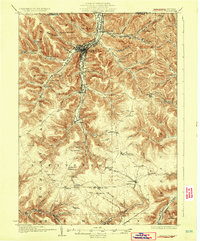
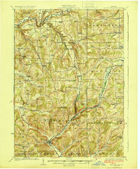 1924 Ellicottville1924 Print · USGSCattaraugus County’s steep valleys and rural schools are preserved here in the mid-1920s, showing the region's transition into the early automotive age. Trace family roots and vanished landmarks like Cascade Park, the Dutch Hill Church, and the Buffalo Rochester and Pittsburgh Railroad corridor.3 unique versions available
 - 1924 Map of Bradford
 1924 Bradford1924 Print · USGSMcKean County's industrial heartland is captured here in the mid-1920s, showing a landscape defined by timber, chemicals, and heavy rail. Trace early infrastructure from the KINZUA VIADUCT to family-named landmarks like Corwins Corners and Bells Camp.2 unique versions available
 - 1924 Map of Franklinville
 1924 Franklinville1924 Print · USGSCattaraugus County agricultural life and rail commerce are documented here in the mid-twenties. Genealogists and local historians can trace family roots through numerous rural landmarks like Siloam Church, County Line Cem, and the Checkered School.3 unique versions available
 - 1925 Map of Springville
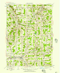
 1925 Springville1925 Print · USGSSouthern Erie County in the mid-twenties shows a landscape of deep valleys and rail-connected villages before the expansion of modern highways. Genealogists can trace family footprints through dozens of district schools like Wheeler Hollow School and rural centers such as Sardinia and Griffins Mills.5 unique versions available
 - 1925 Map of Arcade
 1925 Arcade1925 Print · USGSWestern New York’s rural landscape is captured here in the mid-1920s, a time when one-room schoolhouses and family-named crossroads still defined the countryside. Genealogists can trace property vicinities near Java Village, locate the elusive Cheery Tavern, or follow the path of the Arcade and Attica railroad.4 unique versions available
 - 1926 Map of Bradford
 1926 Bradford1926 Print · USGSNorthwestern Pennsylvania's oil and timber country comes alive in the mid-twenties, centered on the bustling industrial valley of Bradford. Researchers can trace the path of the Bradford Electric Ry, find local homesteads near Custer City, or locate the famed Kinzua Viaduct.4 unique versions available
 - 1933 Map of Smethport, 1960 Print
 1933 Smethport1960 Print · USGSNorthern Pennsylvania’s river valleys were centers of industry and transit in the early 1930s as rail lines followed the winding water gaps. Genealogists can trace family roots through numerous valley schoolhouses like Bush Hill Sch and rural settlements including Duke Center and Turtlepoint.
 - 1936 Map of Kinzua
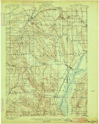
 1936 Kinzua1936 Print · USGSThe Allegheny River valley remains in its natural state in the mid-1930s, long before the creation of the Allegheny Reservoir. Genealogists and historians can locate vanished riverfront settlements like Corydon and Kinzua, as well as the original boundaries of the Cornplanter Indian Reservation.
 - 1937 Map of Smethport
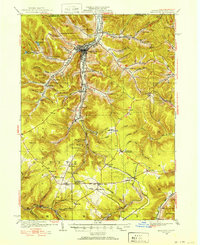
 1937 Smethport1937 Print · USGSMcKean County's river valleys and oil-country settlements are captured here in the mid-1930s as the regional rail network still connected remote hollows. Genealogists and historians can trace the exact locations of local schools like Newell Creek Sch, old family landmarks such as Devils Den, and the rural layout of Smethport.3 unique versions available
 - 1938 Map of Cattaraugus
 1938 Cattaraugus1938 Print · USGSWestern New York in the late thirties is captured here during a transition to modern mapping, anchored by the Erie railroad and the Cattaraugus Indian Reservation. Researchers can trace dozens of local landmarks like the State Asylum, Zoar Bridge, and the Poverty Hill School.
 - 1938 Map of Salamanca, 1954 Print
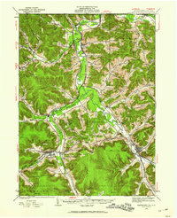
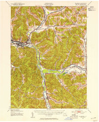 1938 Salamanca1954 Print · USGSIn the late 1930s, this portion of Cattaraugus County was a critical rail and river hub where the Allegheny River meets major transit lines. Researchers can trace the layout of the Allegheny Reservation and locate vanished stop points like Irvine Mills and Kill Buck.2 unique versions available
Showing maps 1-25 of 277
Top cities of Cattaraugus County
- Olean historical maps
- Allegany historical maps
- Salamanca historical maps
- Yorkshire historical maps
- Portville historical maps
- Franklinville historical maps
See more
Frequently asked questions
- What are the different types of historical maps available for Cattaraugus County?
- What is the oldest map of Cattaraugus County?
- Where can I purchase historical maps of Cattaraugus County for my home or office?
- Where can I download high-res historical maps of Cattaraugus County?
- Are there historical topographic maps available for Cattaraugus County?
- Is there historical aerial imagery available for Cattaraugus County?
- Where are historical maps of Cattaraugus County sourced from?