1940s Maps of Cattaraugus County, New York
Explore 15 historic maps of Cattaraugus County from the 1940s. These maps offer a rare glimpse into what life looked like during the 1940s — showing old roads, neighborhoods, homes, and landmarks that have changed or disappeared over time.
Whether you're researching your family's past, planning a metal detecting trip, or studying how Cattaraugus County's landscape evolved across the 1940s, these high-resolution maps are a powerful tool for exploring the history of this region.
- Focus on a specific era: All maps on this page are from the 1940s, giving you a focused view of this time period.
- See what’s changed: Compare century-old streets, trails, and buildings to today's modern landscape using overlays and satellite layers.
- Research with precision: Use these maps for genealogy, historical research, land use analysis, or educational projects.
- View, download, or print: Maps are fully viewable online in high resolution, and can be downloaded or printed for your own records.
Start exploring Cattaraugus County's history through authentic maps from the 1940s. This is your window into the past.
Cattaraugus County, NY maps
(15)- 1941 Map of Cattaraugus
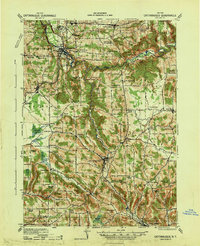 1941 Cattaraugus1941 Print · USGSWestern New York’s rural townships are captured here just before the mid-century, from the Cattaraugus Indian Reservation to the valley of Little Valley. Genealogists can trace dozens of early schoolhouses and local hamlets like Bagdad, Eddyville, and Five Points.
 - 1941 Map of Cherry Creek
 1941 Cherry Creek1941 Print · USGSChautauqua and Cattaraugus counties are captured here at the dawn of the 1940s, when the Erie railroad still bound these rural townships together. Genealogists can trace family footprints through numerous small villages like Forestville, South Dayton, and Charlotte Center.
 - 1941 Map of Kinzua
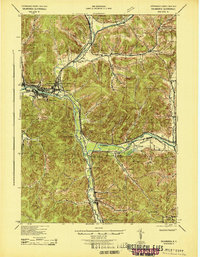
 1941 Kinzua1941 Print · USGSThe Allegheny River valley and the Cornplanter Indian Reservation are shown here in the years before mid-century dam projects forever changed the landscape. Researchers can trace the river-level Pennsylvania Railroad, the Kinzua Coal Mine, and now-submerged settlements like Kinzua and Corydon.3 unique versions available
 - 1941 Map of Ellicottville
 1941 Ellicottville1941 Print · USGSCattaraugus County in the early 1940s is shown here as a landscape of rural school districts and rail-side villages. Researchers can trace the Baltimore and Ohio tracks through Riceville Sta or locate family sites near Dutch Hill Church and Fancy Tract.
 - 1941 Map of Bradford, 1958 Print
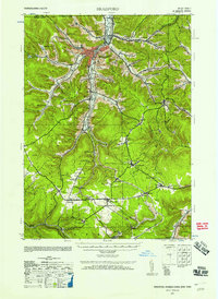 1941 Bradford1958 Print · USGSMcKean County's industrial landscape was at its peak during the early 1940s, marked by a dense network of mountain railroads and small oil-country settlements. Genealogists can trace family roots through numerous rural landmarks like Songbird Sch, Irishtown, and Davis Gifford PO.2 unique versions available
 - 1942 Map of Franklinville
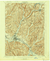
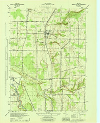
 1942 Franklinville1942 Print · USGSCattaraugus County during the early war years remains a land of small schoolhouses and essential rail junctions. Trace the family roots of rural New York through local landmarks like Siloam Church, County Line Cem, and the unique Checkered School.
 - 1942 Map of Jamestown
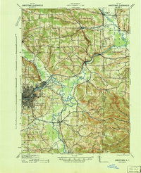 1942 Jamestown1942 Print · USGSJamestown and the Chautauqua County interior are captured here in the early 1940s, showing a landscape defined by industry and deep-set river valleys. Genealogists can trace family roots in old settlements like Frewsburg, Gerry, and the Rutledge Conewango PO.
 - 1943 Map of Olean
 1943 Olean1943 Print · USGSCattaraugus County in the late nineteenth century was a corridor of burgeoning rail and industry along the Allegheny. Researchers can trace the path of the Penna. R.R. through old settlements like Hinsdale and Westons Mills, or locate early landmarks like Rock City.
 - 1943 Map of Randolph
 1943 Randolph1943 Print · USGSCattaraugus County's river-and-rail corridor is captured here in the 1940s, highlighting the Allegheny Indian Reservation and the rugged lands of South Valley. Genealogists and researchers can trace rural life through numerous district landmarks like the Bone Run School, Wolf Run Elko PO, and the chemical plant at Red House.
 - 1943 Map of Salamanca
 1943 Salamanca1943 Print · USGSCattaraugus County during the early 1940s reveals a landscape defined by the intersection of the Allegheny River and major rail lines. Genealogists and rail historians can trace the paths of the Erie and Baltimore and Ohio railroads through Salamanca and Killbuck.
 - 1944 Map of Eden
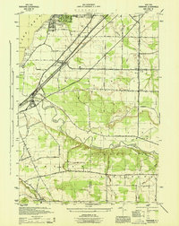
 1944 Eden1944 Print · USGSCoastal Lake Erie and the inland valleys of Erie County are seen here during the mid-1940s. Genealogists can trace family footprints through the Cattaraugus Indian Reservation or old rail stops like Idlewood Sta and Lawton Sta.
 - 1944 Map of North Collins
 1944 North Collins1944 Print · USGSSouthern Erie County is captured here in the mid-1940s, showing the intersection of rail infrastructure and the rural landscape. Genealogists can trace family locations along Mile Strip Road and explore sites like the Thomas Indian School or the Cem near North Collins.
 - 1944 Map of Farnham
 1944 Farnham1944 Print · USGSWestern New York at the height of the war years shows a landscape of busy rail corridors and developing lakeside communities. Genealogists and local historians can trace family locations near Farnham, the borders of the Cattaraugus Indian Reservation, and the small settlement of Smiths Mills.
 - 1944 Map of Bradford
 1944 Bradford1944 Print · USGSMcKean County and the New York borderlands are shown here during the mid-1940s, a period defined by heavy rail traffic and mountain settlements. You can trace old property lines and rural schoolhouses like Bolivar Run Sch, or find the Gifford PO and Big Shanty Sta along the timber and oil valleys.
 - 1949 Map of Kinzua, 1954 Print
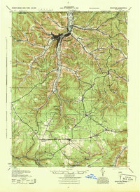
 1949 Kinzua1954 Print · USGSThe Allegheny River valley remains the heart of this region in the late 1940s, just before major changes altered the landscape. Researchers can trace riverside life in Kinzua and Corydon or locate the historic Cornplanter Indian Reservation.4 unique versions available
End of results
Showing maps 1-15 of 15
Top cities of Cattaraugus County
- Olean historical maps
- Allegany historical maps
- Salamanca historical maps
- Yorkshire historical maps
- Portville historical maps
- Franklinville historical maps
See more
Frequently asked questions
- What are the different types of historical maps available for Cattaraugus County?
- What is the oldest map of Cattaraugus County?
- Where can I purchase historical maps of Cattaraugus County for my home or office?
- Where can I download high-res historical maps of Cattaraugus County?
- Are there historical topographic maps available for Cattaraugus County?
- Is there historical aerial imagery available for Cattaraugus County?
- Where are historical maps of Cattaraugus County sourced from?