1960s Maps of Dannemora, New York
Explore 7 historic maps of Dannemora from the 1960s. These maps offer a rare glimpse into what life looked like during the 1960s — showing old roads, neighborhoods, homes, and landmarks that have changed or disappeared over time.
Whether you're researching your family's past, planning a metal detecting trip, or studying how Dannemora's landscape evolved across the 1960s, these high-resolution maps are a powerful tool for exploring the history of this region.
- Focus on a specific era: All maps on this page are from the 1960s, giving you a focused view of this time period.
- See what’s changed: Compare century-old streets, trails, and buildings to today's modern landscape using overlays and satellite layers.
- Research with precision: Use these maps for genealogy, historical research, land use analysis, or educational projects.
- View, download, or print: Maps are fully viewable online in high resolution, and can be downloaded or printed for your own records.
Start exploring Dannemora's history through authentic maps from the 1960s. This is your window into the past.
Dannemora, NY maps
(7)- 1962 Map of Lake Champlain, 1975 Print
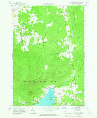
 1962 Lake Champlain1975 Print · USGSLake Champlain and the high peaks of the Adirondacks and Green Mountains are captured here during the mid-twentieth century. Researchers can trace the industrial legacy of the Lyon Mountain Mine and the rail corridors of the Central Vermont RR and Delaware & Hudson RR.3 unique versions available
 - 1964 Map of Ellenburg Center, 1966 Print
 1964 Ellenburg Center1966 Print · USGSNorthern Clinton County in the 1960s was a landscape where the Adirondack wilderness met the farming communities of the Chazy River valley. Researchers can trace family homesteads near Ellenburg Center and Harrigan, or locate lakefront sites at Merrill and Moffitt Island.
 - 1964 Map of Ellenburg Mountain, 1966 Print
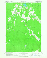
 1964 Ellenburg Mountain1966 Print · USGSClinton County's high country is captured here in the mid-1960s, showing a landscape defined by the expansive Adirondack wilderness and deep blue waters. Genealogists and hikers can trace the old corridors of Plank Road, locate the settlement at Ledger Corners, or find family landmarks like Eagle Point on Chazy Lake.2 unique versions available
 - 1966 Map of Jericho, 1968 Print
 1966 Jericho1968 Print · USGSIn the mid-sixties, the wooded northern reaches of Clinton County show a sparse network of mountain roads and remote settlements. Genealogists and historians can trace family locations near Jericho, Purdys Mill, and Alder Bend, or find old pathways like Old Town Hall Road.2 unique versions available
 - 1966 Map of Dannemora, 1968 Print
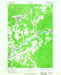 1966 Dannemora1968 Print · USGSClinton County in the 1960s reveals a unique intersection of state institutional land and river-valley industry. Genealogists and historians can trace the Clinton State Prison grounds, family-named roads, and settlements like Picketts Corners and Cadyville.2 unique versions available
 - 1968 Map of Moffitsville, 1970 Print
 1968 Moffitsville1970 Print · USGSClinton County’s rugged Adirondack landscape is captured here in the late sixties, where the wilderness of the State Forest Preserve meets small rural outposts. Genealogists and hikers can trace old routes like Napper Rd and locate landmarks from Lyon Mountain to the banks of the Saranac River.
 - 1968 Map of Lyon Mountain, 1970 Print
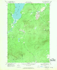 1968 Lyon Mountain1970 Print · USGSAdirondack mining and wilderness intersect in the late sixties as iron works and rail lines define the rugged terrain. Researchers can trace the industrial layout of Lyon Mountain and Standish, from the St Bernards Ch to the sprawling Mine Dumps.
End of results
Showing maps 1-7 of 7
Top cities near Dannemora
- Plattsburgh historical maps
- Peru historical maps
- Beekmantown historical maps
- Schuyler Falls historical maps
- Saranac historical maps
- Mooers historical maps
See more
Top neighborhoods of Dannemora
Frequently asked questions
- What are the different types of historical maps available for Dannemora?
- What is the oldest map of Dannemora?
- Where can I purchase historical maps of Dannemora for my home or office?
- Where can I download high-res historical maps of Dannemora?
- Are there historical topographic maps available for Dannemora?
- Is there historical aerial imagery available for Dannemora?
- Where are historical maps of Dannemora sourced from?