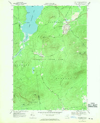
1968 Map of Lyon Mountain
USGS Topo · Published 1970About this map
Lyon Mountain and the mining village of Standish serve as the primary hubs of human activity in this corner of the Adirondack State Park. Heavy industrial footprints are visible near the mountain's northeast slope, where several mines and extensive mine dumps are situated along the Delaware and Hudson railroad line. This area illustrates the late 1960s intersection of Adirondack wilderness preservation and active mineral extraction.
Find a feature on this map
49 named features on this map. Tap any name to fly to it.
Don’t see what you’re looking for? This feature index may not catch every label — zoom into the map to look around manually.
Map Details
Editions of this 1968 Lyon Mountain Map
This is the sole edition of this map. No revisions or reprints were ever made.
Other maps of this area

1906 · Loon Lake
USGS Topo · 1:62,500

1908 · Loon Lake
USGS Topo · 1:62,500

1911 · Lyon Mountain
USGS Topo · 1:62,500

1913 · Lyon Mountain
USGS Topo · 1:62,500

1915 · Churubusco
USGS Topo · 1:62,500

1915 · Chateaugay
USGS Topo · 1:62,500

1931 · Lyon Mountain
USGS Topo · 1:62,500

1943 · Churubusco
USGS Topo · 1:62,500

1943 · Chateaugay
USGS Topo · 1:62,500

1948 · Ogdensburg
USGS Topo · 1:250,000