1950s Maps of Amherst, New York
Explore 5 historic maps of Amherst from the 1950s. These maps offer a rare glimpse into what life looked like during the 1950s — showing old roads, neighborhoods, homes, and landmarks that have changed or disappeared over time.
Whether you're researching your family's past, planning a metal detecting trip, or studying how Amherst's landscape evolved across the 1950s, these high-resolution maps are a powerful tool for exploring the history of this region.
- Focus on a specific era: All maps on this page are from the 1950s, giving you a focused view of this time period.
- See what’s changed: Compare century-old streets, trails, and buildings to today's modern landscape using overlays and satellite layers.
- Research with precision: Use these maps for genealogy, historical research, land use analysis, or educational projects.
- View, download, or print: Maps are fully viewable online in high resolution, and can be downloaded or printed for your own records.
Start exploring Amherst's history through authentic maps from the 1950s. This is your window into the past.
Amherst, NY maps
(5)- 1950 Map of Clarence Center
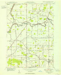 1950 Clarence Center1950 Print · USGSMidcentury Western New York is captured here as rural townships began to evolve around the Erie Canal and Tonawanda Creek. Genealogists and local historians can locate early district schools, the Sulphur Springs Guard Lock, and hamlets like Swormville and Hodgeville Sta.2 unique versions available
 - 1950 Map of Tonawanda East
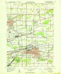
 1950 Tonawanda East1950 Print · USGSNiagara and Erie counties meet along the canal and river during this postwar period of industrial activity and suburban expansion. Genealogists and local historians can trace the foundations of Martinsville and Hodgeville, or locate family sites near Wheatfield Cemetery and School No. 10.2 unique versions available
 - 1950 Map of Lancaster
 1950 Lancaster1950 Print · USGSErie County at the mid-century mark shows a landscape of burgeoning suburbs and vital rail corridors. Genealogists and researchers can trace family landmarks like St Marys High School, the Transit Cem, and old district sites like School No 8.
 - 1950 Map of Buffalo NE
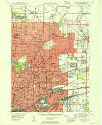 1950 Buffalo NE1950 Print · USGSBuffalo and its northeastern suburbs in the mid-twentieth century show a dense urban fabric of streetcar-era neighborhoods and burgeoning park systems. Genealogists and historians can trace family locations through dozens of numbered schools, large cemeteries like Forest Lawn, and industrial corridors near Sloan and Walden.
 - 1952 Map of Toronto, 1954 Print
 1952 Toronto1954 Print · USGSLake Ontario and the international border define this mid-century landscape of rapid industrial and suburban growth. Researchers can trace the vital shipping and rail corridors of the era, from the Welland Canal to the New York Central Railroad.
End of results
Showing maps 1-5 of 5
Top cities near Amherst
- Buffalo historical maps
- Cheektowaga historical maps
- Tonawanda historical maps
- Hamburg historical maps
- Niagara Falls historical maps
- West Seneca historical maps
See more
Top neighborhoods of Amherst
- Grover Cleveland Terrace historical maps
- Snyder historical maps
- Bucyrus Heights historical maps
- Getzville historical maps
- Audubon Industrial Park historical maps
- Swormville historical maps
See more
Frequently asked questions
- What are the different types of historical maps available for Amherst?
- What is the oldest map of Amherst?
- Where can I purchase historical maps of Amherst for my home or office?
- Where can I download high-res historical maps of Amherst?
- Are there historical topographic maps available for Amherst?
- Is there historical aerial imagery available for Amherst?
- Where are historical maps of Amherst sourced from?