1900-1909 Maps of Newstead, New York
Explore 4 historic maps of Newstead from 1900-1909. These maps offer a rare glimpse into what life looked like during the 1900s — showing old roads, neighborhoods, homes, and landmarks that have changed or disappeared over time.
Whether you're researching your family's past, planning a metal detecting trip, or studying how Newstead's landscape evolved across the 1900s, these high-resolution maps are a powerful tool for exploring the history of this region.
- Focus on a specific era: All maps on this page are from the 1900s, giving you a focused view of this time period.
- See what’s changed: Compare century-old streets, trails, and buildings to today's modern landscape using overlays and satellite layers.
- Research with precision: Use these maps for genealogy, historical research, land use analysis, or educational projects.
- View, download, or print: Maps are fully viewable online in high resolution, and can be downloaded or printed for your own records.
Start exploring Newstead's history through authentic maps from the 1900s. This is your window into the past.
Newstead, NY maps
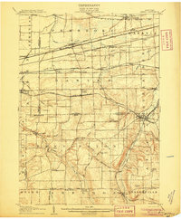
(4)- 1902 Map of Lockport
 1902 Lockport1902 Print · USGSNiagara and Erie Counties thrived at the turn of the century as the Erie Canal and heavy rail transformed the region. Researchers can trace ancestral property near Lockport or locate vanished stops along the Batavia and Tonawanda Shore Line and near Reynales Basin.6 unique versions available
 - 1905 Map of Attica
 1905 Attica1905 Print · USGSWestern New York at the turn of the century shows a landscape dominated by a massive web of competing railroads. Genealogists can trace family names and small hamlets like Folsomdale, Darien Center, and the industrial hub at Attica.5 unique versions available
 - 1905 Map of Depew
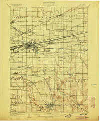 1905 Depew1905 Print · USGSEastern Erie County at the height of the steam era reveals a complex network of major rail lines and rural hamlets. Genealogists and historians can trace old property lines and rail stations like Looneyville, Grimesville, and the early development of Depew.6 unique versions available
 - 1905 Map of Lockport, 1906 Print
 1905 Lockport1906 Print · USGSNiagara and Erie counties at the height of the canal and rail era show a landscape defined by the Erie Canal. Trace family roots in Lockport or explore early transit networks through Transit Sta., Akron, and the Electric R. R.
End of results
Showing maps 1-4 of 4
Top cities near Newstead
- Amherst historical maps
- Cheektowaga historical maps
- West Seneca historical maps
- Lancaster historical maps
- Clarence historical maps
- Orchard Park historical maps
See more
Top neighborhoods of Newstead
- South Newstead historical maps
- Sand Hill historical maps
- Swifts Mills historical maps
- Murrays Corner historical maps
- Akron historical maps
Frequently asked questions
- What are the different types of historical maps available for Newstead?
- What is the oldest map of Newstead?
- Where can I purchase historical maps of Newstead for my home or office?
- Where can I download high-res historical maps of Newstead?
- Are there historical topographic maps available for Newstead?
- Is there historical aerial imagery available for Newstead?
- Where are historical maps of Newstead sourced from?