Old Maps of Genesee County, New York for Metal Detecting
Plan your next treasure hunt with 172 historic maps of Genesee County. Find old homesites, ghost towns, trails, and gathering spots that may be lost to time — perfect for identifying promising metal detecting locations.
- Locate forgotten sites: Uncover places like long-lost settlements, abandoned rail lines, or gathering spots.
- Plan better hunts: Use map overlays combined with LiDAR or satellite views to narrow in on historically rich areas.
- Made for detectorists: Thousands of hobbyists use these maps to discover relics, coins, and hidden history.
Use these historic maps to boost your research and find new opportunities beneath the surface of Genesee County.
Genesee County, NY maps
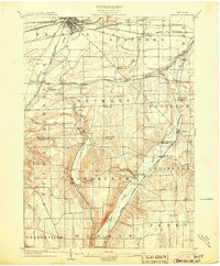
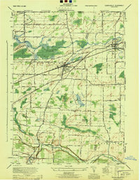
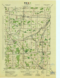
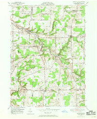
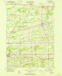
(172)- 1897 Map of Albion
 1897 Albion1897 Print · USGSWestern New York at the close of the nineteenth century is defined by its busy transit corridors and rural crossroads. Researchers can trace ancestral farmsteads and old trade routes near the Erie Canal, Oak Orchard Swamp, and Rich's Corners.7 unique versions available
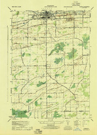
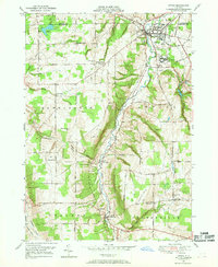
 - 1897 Map of Medina
 1897 Medina1897 Print · USGSWestern New York at the close of the nineteenth century reveals a landscape defined by the Erie Canal and the Tonawanda Indian Reservation. Researchers can trace the early rail-and-water economy through settlements like Medina, Akron, and the vanished stops of Smithville Sta.7 unique versions available
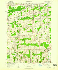
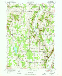
 - 1899 Map of Brockport
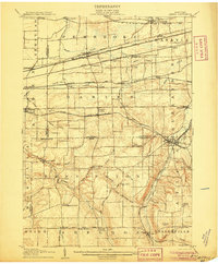
 1899 Brockport1899 Print · USGSMonroe and Genesee Counties are captured here at the close of the nineteenth century as the industrial power of the Erie Canal and five different railroads reshaped the landscape. Genealogists and local historians can trace family-named sites and vanished hamlets like Moreton Farm, Hinkleyville, and Stone Church.8 unique versions available
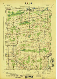
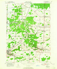
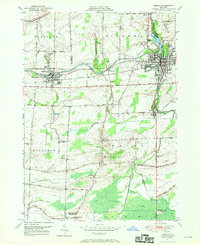
 - 1904 Map of Batavia
 1904 Batavia1904 Print · USGSWestern New York at the turn of the century shows a landscape dominated by competing railroad interests and agricultural hamlets. Genealogists can trace family connections between Pearl Creek, Attica Center, and Stafford while following the routes of the Lehigh Valley and Erie R. R. through the valleys.7 unique versions available
 - 1904 Map of Caledonia
 1904 Caledonia1904 Print · USGSLivingston County and its surrounding borders are shown here at the height of the early railroad era. Researchers can trace the complex rail junctions at Caledonia or locate vanished landmarks and post offices like Wadsworth P.O. S.Greigsville and Retsof.6 unique versions available
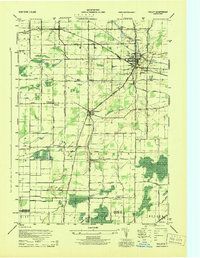
 - 1905 Map of Attica
 1905 Attica1905 Print · USGSWestern New York at the turn of the century shows a landscape dominated by a massive web of competing railroads. Genealogists can trace family names and small hamlets like Folsomdale, Darien Center, and the industrial hub at Attica.5 unique versions available
 - 1934 Map of Brockport
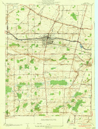 1934 Brockport1934 Print · USGSBrockport and the surrounding Monroe County countryside are captured in the mid-1930s as a thriving hub of canal and rail transport. Genealogists and local historians can trace the school districts, find rural cemeteries like Lake View Cemetery, and locate vanished landmarks along the Barge Canal.
 - 1935 Map of Churchville
 1935 Churchville1935 Print · USGSWestern Monroe County was a hub of rail travel and agriculture in the 1930s. Genealogists and historians can trace the foundations of local life through sites like Churchville Park, the rural settlement of Beulah, and old local schools like School No 9.
 - 1944 Map of Churchville
 1944 Churchville1944 Print · USGSMonroe and Genesee counties are captured here in the mid-1940s, showing a landscape defined by the New York Central System and Bergen Swamp Wild Life Sanctuary. Researchers can trace rural school districts like School No 9 and settlements at Stone Church or Beulah.
 - 1944 Map of Alexander
 1944 Alexander1944 Print · USGSGenesee County at the close of the war reveals a landscape dominated by a vital rail network and small farming hamlets. Local researchers can trace old routes near Darien City or locate historical sites like Hillside Cemetery and Lehigh Sta.
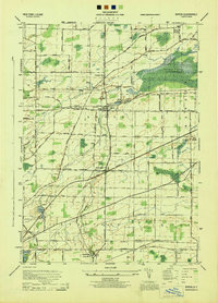
 - 1944 Map of Holley
 1944 Holley1944 Print · USGSOrleans and Genesee counties during the mid-forties showcase a landscape of canal-side industry and rural school districts. Genealogists can locate family-named landmarks and schools including School No 12 and Maplewood Cemetery.
 - 1944 Map of Byron
 1944 Byron1944 Print · USGSGenesee County's rural landscape at the height of the Second World War was a thriving network of rail-side hamlets and small school districts. Genealogists and local historians can trace family roots through labeled sites like School No 2, the village of South Byron, and the Bergen Swamp Wild-Life Sanctuary.
 - 1944 Map of Stafford
 1944 Stafford1944 Print · USGSWestern New York’s rural landscape is captured here during the mid-1940s, showcasing the intersection of heavy rail and local farming life. Genealogists can locate family-named roads and several rural schoolhouses like School No 8 and School No 11.
 - 1944 Map of Le Roy
 1944 Le Roy1944 Print · USGSLe Roy and its surrounding townships are shown at the height of the steam-to-diesel rail era, where three major lines intersect. Genealogists can locate family landmarks such as Machpelah Cemetery, Union Corners, and many rural schoolhouses like School No 7.
 - 1944 Map of Leicester
 1944 Leicester1944 Print · USGSLivingston County’s Genesee Valley was a powerhouse of rail transport and rural industry in the mid-forties. Genealogists and industrial historians can trace early property lines near Olivet Cem, find School No 7, and follow the junction of the Genesee and Wyoming Railroad through Retsof and Leicester.
 - 1944 Map of Albion
 1944 Albion1944 Print · USGSOrleans County during the mid-1940s centers on the vital Erie Canal corridor and the village of Albion. Genealogists and historians can trace the locations of numerous district schools, the Orleans County Hospital, and family-named corners like Richs Corners.
 - 1949 Map of Attica, 1953 Print
 1949 Attica1953 Print · USGSWestern New York at mid-century reveals a dense network of major railroads and rural hamlets across Genesee and Wyoming counties. Genealogists and historians can trace family locations through numerous numbered schools, named crossroads like Brick House Corners, and landmarks such as the Attica State Prison.
 - 1949 Map of Alexander, 1960 Print
 1949 Alexander1960 Print · USGSPost-war Genesee County retains its deep railroad identity, with four major lines crossing the townships of Alexander and Darien. Genealogists can trace family footprints at Hillside Cem, School No 8, and the old station at Sawens.2 unique versions available
 - 1949 Map of Akron, 1965 Print
 1949 Akron1965 Print · USGSWestern New York at mid-century reveals a landscape shaped by indigenous heritage and rural development. Genealogists and historians can trace family-named roads and old rail stops like Basom and Pembroke Sta, or locate sites like the Council House and Evergreen Cem.
 - 1949 Map of Cowlesville, 1969 Print
 1949 Cowlesville1969 Print · USGSWyoming County's rural character is well-preserved here in the years following the war, showing a landscape defined by small crossroads hamlets and creek-side settlements. Genealogists can trace family roots through sites like Persons Corners, Persons Cem, and several numbered schoolhouses including School No 19.
 - 1949 Map of Attica, 1969 Print
 1949 Attica1969 Print · USGSWestern New York’s rural landscape is captured here in the late 1940s, centered on the rail hub of Attica. Researchers can trace the dual rail lines of the Erie RR and Attica and Arcade RR or locate family sites near Varysburg and East Bennington.2 unique versions available
 - 1949 Map of Medina, 1970 Print
 1949 Medina1970 Print · USGSThe Erie Canal and New York Central railroad define this late 1940s landscape between Middleport and Medina. Researchers can trace rural life through landmarks like School No 15, the Site of Neuter Fort, and Boxwood Cem.
 - 1949 Map of Dale, 1974 Print
 1949 Dale1974 Print · USGSMid-century Wyoming County is defined by the winding Erie Railroad and a network of rural hamlets. Local historians can trace family-named crossroads and burial sites like Sickleys Corners, Vernal Corners Cem, and Dutton Hill.3 unique versions available
 - 1950 Map of Corfu
 1950 Corfu1950 Print · USGSThe Erie and Genesee County borderlands thrived at mid-century as a vital railroad corridor between Buffalo and Batavia. Researchers can trace the path of four major rail lines and locate rural landmarks like Brick House Corners, School No. 13, and Fargo.2 unique versions available
 - 1950 Map of Elmira
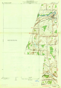
 1950 Elmira1950 Print · USGSThe Finger Lakes region thrived in the late 1940s as a hub of industry and transport. Trace family roots and vanished landmarks near Seneca Lake or explore the rail lines of the Erie RR and the sprawling Seneca Ordnance Depot.2 unique versions available
Showing maps 1-25 of 172
Top cities of Genesee County
- Batavia historical maps
- LeRoy historical maps
- Batavia historical maps
- Pembroke historical maps
- Oakfield historical maps
- Bergen historical maps
See more
Frequently asked questions
- What are the different types of historical maps available for Genesee County?
- What is the oldest map of Genesee County?
- Where can I purchase historical maps of Genesee County for my home or office?
- Where can I download high-res historical maps of Genesee County?
- Are there historical topographic maps available for Genesee County?
- Is there historical aerial imagery available for Genesee County?
- Where are historical maps of Genesee County sourced from?