1930s Maps of Genesee County, New York
Explore 2 historic maps of Genesee County from the 1930s. These maps offer a rare glimpse into what life looked like during the 1930s — showing old roads, neighborhoods, homes, and landmarks that have changed or disappeared over time.
Whether you're researching your family's past, planning a metal detecting trip, or studying how Genesee County's landscape evolved across the 1930s, these high-resolution maps are a powerful tool for exploring the history of this region.
- Focus on a specific era: All maps on this page are from the 1930s, giving you a focused view of this time period.
- See what’s changed: Compare century-old streets, trails, and buildings to today's modern landscape using overlays and satellite layers.
- Research with precision: Use these maps for genealogy, historical research, land use analysis, or educational projects.
- View, download, or print: Maps are fully viewable online in high resolution, and can be downloaded or printed for your own records.
Start exploring Genesee County's history through authentic maps from the 1930s. This is your window into the past.
Genesee County, NY maps
(2)- 1934 Map of Brockport
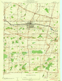 1934 Brockport1934 Print · USGSBrockport and the surrounding Monroe County countryside are captured in the mid-1930s as a thriving hub of canal and rail transport. Genealogists and local historians can trace the school districts, find rural cemeteries like Lake View Cemetery, and locate vanished landmarks along the Barge Canal.
 - 1935 Map of Churchville
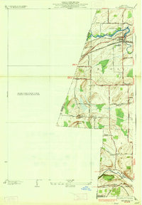 1935 Churchville1935 Print · USGSWestern Monroe County was a hub of rail travel and agriculture in the 1930s. Genealogists and historians can trace the foundations of local life through sites like Churchville Park, the rural settlement of Beulah, and old local schools like School No 9.
End of results
Showing maps 1-2 of 2
Top cities of Genesee County
- Batavia historical maps
- LeRoy historical maps
- Batavia historical maps
- Pembroke historical maps
- Oakfield historical maps
- Bergen historical maps
See more
Frequently asked questions
- What are the different types of historical maps available for Genesee County?
- What is the oldest map of Genesee County?
- Where can I purchase historical maps of Genesee County for my home or office?
- Where can I download high-res historical maps of Genesee County?
- Are there historical topographic maps available for Genesee County?
- Is there historical aerial imagery available for Genesee County?
- Where are historical maps of Genesee County sourced from?