1950s Maps of Genesee County, New York
Explore 31 historic maps of Genesee County from the 1950s. These maps offer a rare glimpse into what life looked like during the 1950s — showing old roads, neighborhoods, homes, and landmarks that have changed or disappeared over time.
Whether you're researching your family's past, planning a metal detecting trip, or studying how Genesee County's landscape evolved across the 1950s, these high-resolution maps are a powerful tool for exploring the history of this region.
- Focus on a specific era: All maps on this page are from the 1950s, giving you a focused view of this time period.
- See what’s changed: Compare century-old streets, trails, and buildings to today's modern landscape using overlays and satellite layers.
- Research with precision: Use these maps for genealogy, historical research, land use analysis, or educational projects.
- View, download, or print: Maps are fully viewable online in high resolution, and can be downloaded or printed for your own records.
Start exploring Genesee County's history through authentic maps from the 1950s. This is your window into the past.
Genesee County, NY maps
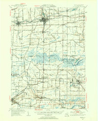
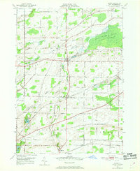
(31)- 1950 Map of Corfu
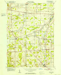
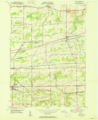 1950 Corfu1950 Print · USGSThe Erie and Genesee County borderlands thrived at mid-century as a vital railroad corridor between Buffalo and Batavia. Researchers can trace the path of four major rail lines and locate rural landmarks like Brick House Corners, School No. 13, and Fargo.2 unique versions available
 - 1950 Map of Elmira
 1950 Elmira1950 Print · USGSThe Finger Lakes region thrived in the late 1940s as a hub of industry and transport. Trace family roots and vanished landmarks near Seneca Lake or explore the rail lines of the Erie RR and the sprawling Seneca Ordnance Depot.2 unique versions available
 - 1950 Map of Knowlesville
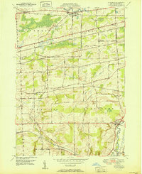
 1950 Knowlesville1950 Print · USGSOrleans County at mid-century remains a landscape defined by the historic Erie Canal and the transit lines of the New York Central. Genealogists and local historians can trace family plots at Millville Cem or locate old schoolhouses and settlements like East Shelby and West Barre.3 unique versions available
 - 1950 Map of Batavia
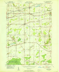
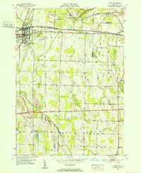
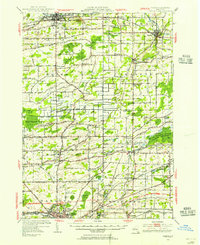
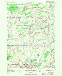
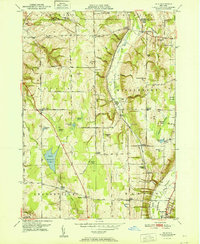
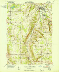
 1950 Batavia1950 Print · USGSWestern New York at the mid-century shows a bustling landscape of rail hubs and rural crossroads. Researchers can trace the heritage of Batavia and Wyoming while locating local landmarks like the Pioneer Salt Well, Bethany Ch, and the Fairgrounds.
 - 1950 Map of Churchville, 1952 Print
 1950 Churchville1952 Print · USGSThe rural borderlands of Genesee and Monroe Counties come alive in this mid-century survey of the New York Central rail corridor. Researchers can trace historic farmstead locations and early settlements like Stone Church, Jericon Corners, and the scenic Buttermilk Falls.2 unique versions available
 - 1950 Map of Stafford, 1952 Print
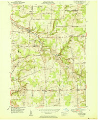
 1950 Stafford1952 Print · USGSGenesee County at the mid-century was a bustling hub of New York rail traffic and small-town commerce. Researchers can trace family history through the Stafford Cem or locate vanished local landmarks like the Bel-air Ranch Health Camp and Suicide Corners.3 unique versions available
 - 1950 Map of Le Roy, 1952 Print
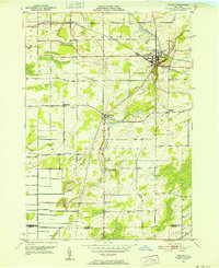
 1950 Le Roy1952 Print · USGSWestern New York at mid-century reveals a landscape shaped by competing rail lines and rural settlements. You can trace the early industrial footprint of Le Roy and find family-named landmarks like Machpelah Cem, St Anthony Ch, and the GULF.4 unique versions available
 - 1950 Map of Batavia South, 1952 Print
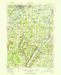
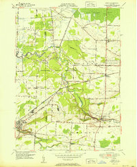
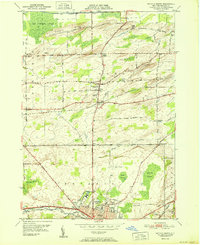
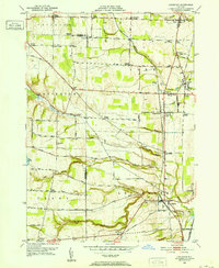
 1950 Batavia South1952 Print · USGSThe Genesee County countryside south of Batavia in the early fifties was a busy junction of four major railroads. Genealogists and local historians can trace the paths between rural hamlets like Linden, Brookville, and Bethany Center, or locate landmarks such as Jackson Sch and the County Home.3 unique versions available
 - 1950 Map of Holley, 1952 Print
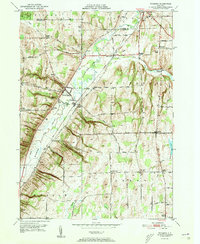
 1950 Holley1952 Print · USGSOrleans County is captured at mid-century, showcasing the enduring influence of the Erie Canal and rail lines on local settlement. Genealogists and researchers can locate several rural landmarks including Pioneer Cem, Robinson Hill Sch, and the hamlet of Fancher.3 unique versions available
 - 1950 Map of Medina, 1956 Print
 1950 Medina1956 Print · USGSOrleans and Genesee Counties are mapped here in the mid-fifties, showing the industrial pulse of the Erie Canal and New York Central corridor. Genealogists can locate numerous rural schools and landmarks like the Site of Neuter Fort, Boxwood Cem, and the Tonawanda Indian Reservation.2 unique versions available
 - 1950 Map of Albion, 1956 Print
 1950 Albion1956 Print · USGSOrleans and Genesee counties sit at a fascinating crossroads in the early fifties as new highway systems began to parallel the historic water and rail routes. Researchers can trace the heritage of local hamlets like South Barre and North Bergen, or locate landmarks like the State Training School for Girls and Mt Albion Cem.2 unique versions available
 - 1950 Map of Oakfield, 1963 Print
 1950 Oakfield1963 Print · USGSGenesee County at mid-century shows a landscape defined by the intersection of traditional rail lines and the rising New York State Thruway. Genealogists can locate family landmarks such as Reed Cem, the Stone Schoolhouse, and the small settlement of South Alabama.
 - 1950 Map of Albion, 1965 Print
 1950 Albion1965 Print · USGSOrleans County is centered on the village of Albion in the early 1950s, showing a landscape defined by the historic Erie Canal and agricultural crossroads. Researchers can trace local heritage through sites like the State Training School for Girls, Barre Center, and Mt Albion Cem.3 unique versions available
 - 1950 Map of Byron, 1969 Print
 1950 Byron1969 Print · USGSMid-century Genesee County comes alive through this 1950 survey, showcasing the vital rail corridors and rural hamlets of the Byron region. Family historians can locate several burial grounds, including Sodom Cem and Walkers Cem, while tracing the paths of the New York Central Railroad and Lehigh Valley Railroad.3 unique versions available
 - 1950 Map of Batavia North, 1970 Print
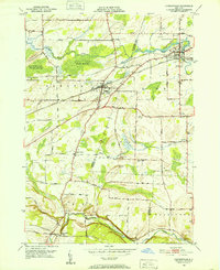
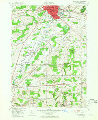
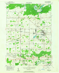
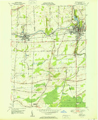
 1950 Batavia North1970 Print · USGSGenesee County at mid-century centers on the industrial and institutional expansion of Batavia. Researchers can trace the legacy of local landmarks like the State School for the Blind, the Batavia Downs track, and rural hamlets such as East Elba and Langton Corners.2 unique versions available
 - 1951 Map of Wyoming
 1951 Wyoming1951 Print · USGSWestern New York in the early fifties was a landscape of salt works and valley farms. Genealogists and local historians can trace family roots through landmarks like the Pioneer Salt Well, the Pioneer Cemetery, and crossroads such as Lambs Corner or Saltvale.4 unique versions available
 - 1951 Map of Akron
 1951 Akron1951 Print · USGSThe Tonawanda Indian Reservation and the village of Akron are documented here at the start of the 1950s. Genealogists can trace family burial sites at Evergreen Cem and Long House Cem, or locate historic civic hubs like the Council House and Basom.2 unique versions available
 - 1951 Map of Dale
 1951 Dale1951 Print · USGSMid-century Wyoming County life is centered on the deep ravines and rail lines carved by Tonawanda Creek. Genealogists can trace early rural neighborhoods through family-named landmarks like Williams Corners, Brainard Cem, and School No 4.
 - 1951 Map of Cowlesville
 1951 Cowlesville1951 Print · USGSWestern New York's rural Wyoming County townships are shown here in the early fifties, a landscape of creek-fed valleys and small crossroads hamlets. Researchers can trace historic district schools and cemeteries like School No 12 and Fairview Cem near Cowlesville.
 - 1951 Map of Batavia North
 1951 Batavia North1951 Print · USGSGenesee County's northern corridor is captured here in the early fifties as Batavia's urban reach meets the surrounding swamplands and muck farms. Genealogists and local historians can trace family roots through Gardner Cem, the Veterans Hospital, and small hamlets like East Elba and Daws.
 - 1951 Map of Medina
 1951 Medina1951 Print · USGSOrleans and Niagara Counties hum with activity in the mid-century as the Erie Canal and rail lines drive the local economy. Genealogists can locate several rural schoolhouses and family plots, such as Boxwood Cem and School No 16.
 - 1951 Map of Attica
 1951 Attica1951 Print · USGSWestern New York's Wyoming County is surveyed here in the early postwar years, centered on the vital rail hub of Attica. Genealogists and historians can trace the rural landscape through family-named sites and landmarks like Danley Corners, St Vincent Cem, and the County Home.
 - 1951 Map of Alexander
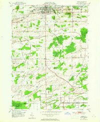
 1951 Alexander1951 Print · USGSGenesee County's agricultural and rail-connected landscape is preserved here in the mid-twentieth century. Researchers can trace historic property access along Wortendyke Road and locate rural hubs like Sawens or Maple Hill Cem.
 - 1951 Map of Leicester, 1952 Print
 1951 Leicester1952 Print · USGSLivingston and Wyoming Counties are captured here in the early 1950s, showing a landscape of salt mining and rural crossroads. Researchers can trace family sites at Simmons Corners and Peoria, or locate community landmarks like Covington Ch and Mt Nash Cem.3 unique versions available
 - 1951 Map of Caledonia, 1956 Print
 1951 Caledonia1956 Print · USGSThe Genesee Valley flourished as a rail crossroads in the early fifties, where five major lines converged near the river. Local historians can trace family-named corners and rural institutions like St Columbus Ch, Machpelah Cem, and Retsof Central Sch.2 unique versions available
Showing maps 1-25 of 31
Top cities of Genesee County
- Batavia historical maps
- LeRoy historical maps
- Batavia historical maps
- Pembroke historical maps
- Oakfield historical maps
- Bergen historical maps
See more
Frequently asked questions
- What are the different types of historical maps available for Genesee County?
- What is the oldest map of Genesee County?
- Where can I purchase historical maps of Genesee County for my home or office?
- Where can I download high-res historical maps of Genesee County?
- Are there historical topographic maps available for Genesee County?
- Is there historical aerial imagery available for Genesee County?
- Where are historical maps of Genesee County sourced from?