1980s Maps of Greene County, New York
Explore 7 historic maps of Greene County from the 1980s. These maps offer a rare glimpse into what life looked like during the 1980s — showing old roads, neighborhoods, homes, and landmarks that have changed or disappeared over time.
Whether you're researching your family's past, planning a metal detecting trip, or studying how Greene County's landscape evolved across the 1980s, these high-resolution maps are a powerful tool for exploring the history of this region.
- Focus on a specific era: All maps on this page are from the 1980s, giving you a focused view of this time period.
- See what’s changed: Compare century-old streets, trails, and buildings to today's modern landscape using overlays and satellite layers.
- Research with precision: Use these maps for genealogy, historical research, land use analysis, or educational projects.
- View, download, or print: Maps are fully viewable online in high resolution, and can be downloaded or printed for your own records.
Start exploring Greene County's history through authentic maps from the 1980s. This is your window into the past.
Greene County, NY maps
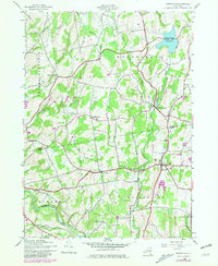
(7)- 1980 Map of Hunter
 1980 Hunter1980 Print · USGSThe Catskill high country comes into focus in this study of the mountain corridor before the modern era. Genealogists can trace family names at Evergreen Cem or locate historic parish sites like St Johns Ch and East Kill Valley Ch.
 - 1980 Map of Hensonville, 1981 Print
 1980 Hensonville1981 Print · USGSHigh peaks and narrow kills define these Greene County highlands during the late twentieth century. Researchers can trace the Old Railroad Grade and find family names at cemeteries near Hensonville and Cornwallville.2 unique versions available
 - 1980 Map of Greenville, 1981 Print
 1980 Greenville1981 Print · USGSThe Albany and Greene County borderlands in the early eighties show a landscape of hamlets connected by winding creeks and country roads. Genealogists and historians can trace family burial sites like Locust Cem and rural settlements such as South Westerlo and Norton Hill.
 - 1980 Map of Hudson South, 1981 Print
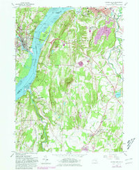 1980 Hudson South1981 Print · USGSThe Hudson River valley at the start of the 1980s reveals a blend of historic estates, maritime industry, and established river towns. Genealogists and historians can trace riverside landings and local institutions like Olana Historic Site, St Anthonys Seminary, and the Germantown Reformed Cemetery.
 - 1980 Map of Hudson North, 1981 Print
 1980 Hudson North1981 Print · USGSThe Hudson River valley at the dawn of the 1980s reveals a landscape of industrial river towns and sprawling institutions. Genealogists and historians can trace family sites at Limestreet Cem or explore the rail-linked history of Stockport Sta and Newton Hook.
 - 1986 Map of Pepacton Reservoir
 1986 Pepacton Reservoir1986 Print · USGSThe Catskills in the mid-eighties show a landscape shaped by the Pepacton Reservoir and protected wilderness. Local historians can trace mountain rail corridors like the Delaware & Ulster RR and locate high-elevation landmarks from Slide Mountain to Hunter Mountain.2 unique versions available
 - 1986 Map of Pittsfield
 1986 Pittsfield1986 Print · USGSThe Berkshires and the Hudson Valley meet in the mid-1980s, documenting a cross-border landscape of mountain forests and river towns. Genealogists and historians can trace the paths of Conrail and the Taconic State Parkway as they pass through Stockbridge, Great Barrington, and Kinderhook.2 unique versions available
End of results
Showing maps 1-7 of 7
Top cities of Greene County
- Catskill historical maps
- Coxsackie historical maps
- Cairo historical maps
- Athens historical maps
- Greenville historical maps
- New Baltimore historical maps
See more
Frequently asked questions
- What are the different types of historical maps available for Greene County?
- What is the oldest map of Greene County?
- Where can I purchase historical maps of Greene County for my home or office?
- Where can I download high-res historical maps of Greene County?
- Are there historical topographic maps available for Greene County?
- Is there historical aerial imagery available for Greene County?
- Where are historical maps of Greene County sourced from?