Old Maps of Greene County, New York for Hiking & Exploration
Hike through history with 191 historic maps of Greene County. Explore old trails, ghost towns, and forgotten backroads — perfect for outdoor adventurers and local explorers.
- Rediscover forgotten places: Map out old mining camps, roads, and footpaths that no longer exist on modern maps.
- Layer with modern tools: Combine with LiDAR or satellite views to plan hikes through historical terrain.
- Made for exploration: Popular among hikers, overlanders, and local history lovers.
Use these maps to find adventure and explore the hidden past of Greene County.
Greene County, NY maps
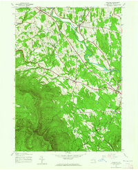
(191)- 1892 Map of Kaaterskill, 1957 Print
 1892 Kaaterskill1957 Print · USGSThe high Catskills of the 1890s reveal a landscape of grand hotels and rugged peaks during the peak of the mountain resort era. Genealogists and historians can trace the foundations of Onteora Park, the route of the Elevating R. R., and lost hamlets like Dutch Settlement.3 unique versions available
 - 1893 Map of Kaaterskill
 1893 Kaaterskill1893 Print · USGSThe high peaks and resort colonies of the late nineteenth century are mapped here in exceptional detail. Genealogists and rail historians can trace the paths of the Otis Elevating R R and the Catskill Mtn R R or locate old sites like Dutch Settlement and Mountain House.
 - 1893 Map of Coxsackie
 1893 Coxsackie1893 Print · USGSThe Hudson River valley at the close of the 19th century shows a landscape defined by waterborne trade and expanding rail networks. Genealogists and local historians can trace family-named landmarks like Stanton Hill, ferry landings at Nuttenhook, and rail hubs like Coeyman Junction.
 - 1893 Map of Durham
 1893 Durham1893 Print · USGSThe northern Catskill foothills and the Greene-Albany county line appear here in the early 1890s, when valley farming and small-scale industry defined the region. Genealogists and hikers can trace the original paths to Union Society, Cairo Forge, and the high peaks of the Black Head Mountains.
 - 1894 Map of Coxsackie
 1894 Coxsackie1894 Print · USGSThe Hudson River valley at the close of the 19th century was a hub of rail and river transit between Greene and Columbia counties. Genealogists can trace family names at Stanton Hill and Stephensville or locate long-lost stops like New Baltimore Sta. and Coxsackie Station.8 unique versions available
 - 1894 Map of Kaaterskill
 1894 Kaaterskill1894 Print · USGSThe Catskills come alive in the 1890s as a premier destination for mountain tourism and timber. You can trace the early rail lines serving the Mountain House, locate the Victorian-era enclaves of Onteora Park and Twilight Park, or find family roots in Yankeetown.
 - 1894 Map of Durham
 1894 Durham1894 Print · USGSThe northern Catskills transition from rolling valley farms to high mountain peaks in the late nineteenth century. Genealogists and hikers can trace old routes between Preston Hollow, Hensonville, and the summits of the Black Head Mountains.10 unique versions available
 - 1895 Map of Catskill
 1895 Catskill1895 Print · USGSThe Hudson River valley at the close of the 19th century was a landscape of bustling river ports and expanding rail lines. Genealogists and researchers can trace family lands near Saugerties, locate the old Burden Dock, or follow the route of the Catskill Mountain and Cairo R. R.10 unique versions available
 - 1899 Map of Kaaterskill
 1899 Kaaterskill1899 Print · USGSThe Catskills in the late nineteenth century show a unique landscape of mountain tourism and rail infrastructure. Trace the early hotel era through the Mountain House, the Otis Elevating Ry., and the high-elevation hamlets of Tannersville and Onteora Park.2 unique versions available
 - 1900 Map of Phoenicia, 1963 Print
 1900 Phoenicia1963 Print · USGSThe high Catskills at the turn of the century are captured here in a moment of emerging tourism and mountain settlement. Genealogists and hikers can trace the original locations of the Grand Hotel, the remote Winnisook Lodge, and the rail stops at Mt Pleasant Station.
 - 1901 Map of Margaretville, 1961 Print
 1901 Margaretville1961 Print · USGSThe Catskills at the turn of the century are defined here by river-valley settlements and the Ulster and Delaware railroad line. Genealogists and historians can trace family-named hollows and vanished settlements like Grant Mills, Arena, and Griffin Corners.
 - 1901 Map of Gilboa, 1961 Print
 1901 Gilboa1961 Print · USGSThe northern Catskills at the start of the twentieth century reveal a landscape of river-valley hamlets and high mountain peaks. Genealogists and historians can trace original homesteads near Gilboa, Prattsville, and Livingstonville, or find landmarks like Pratt Rocks.
 - 1903 Map of Gilboa
 1903 Gilboa1903 Print · USGSThe Schoharie Valley at the turn of the century shows a landscape of clustered hamlets and prominent mountain peaks before major regional changes. Researchers can trace the layout of early settlements like Gilboa and Prattsville, or locate family landmarks such as Pratt Rocks and Manorkill Falls.9 unique versions available
 - 1903 Map of Phoenicia
 1903 Phoenicia1903 Print · USGSThe Catskills come alive at the turn of the century, showing the mountain rail corridor and early grand resorts. Researchers can trace the Ulster and Delaware line through Phoenicia to the Highmount Grand Hotel and Winnisook Lodge.9 unique versions available
 - 1903 Map of Kaaterskill, 1906 Print
 1903 Kaaterskill1906 Print · USGSThe Catskills come alive in the early twentieth century through this record of mountain resorts and steep-grade rail lines. Researchers can trace the legendary Mountain House, the Otis Elevating R.R., and the remote Dutch Settlement.10 unique versions available
 - 1904 Map of Hobart
 1904 Hobart1904 Print · USGSThe northern Catskills and Delaware River headwaters come to life in this study of the region just after the turn of the century. You can trace the Ulster and Delaware rail line through high-elevation settlements like Stamford, Hobart, and Roxbury.5 unique versions available
 - 1904 Map of Margaretville
 1904 Margaretville1904 Print · USGSThe Catskills' high-valley communities thrive along the Ulster and Delaware RR at the turn of the century. Trace old family farmsteads and rural mountain hamlets like Arena, New Kingston, and Griffin Corners as they appeared in 1904.7 unique versions available
 - 1929 Map of Coxsackie
 1929 Coxsackie1929 Print · USGSThe Hudson River valley in the late twenties was a bustling corridor of rail lines and river landings between Albany and Catskill. Genealogists and historians can trace family locations through dozens of numbered schoolhouses, the industrial works at Stottville, and the transit hubs of Schodack Landing and West Coxsackie.4 unique versions available
 - 1934 Map of Catskill, 1960 Print
 1934 Catskill1960 Print · USGSThe Hudson Valley during the mid-1930s shows a landscape of riverfront commerce and deep-rooted rural townships. Genealogists and local historians can locate country schools like Schuylerhook Sch and historic landmarks like the Birthplace of Robert Livingston.2 unique versions available
 - 1938 Map of Catskill
 1938 Catskill1938 Print · USGSThe Hudson Valley in the late thirties remains a landscape of river-side industry and deep colonial heritage. Researchers can trace family sites from Kiskatom Ch to the Birthplace of Robert Livingston or locate vanished local landmarks like Walker Mill.2 unique versions available
 - 1941 Map of Catskill, 1945 Print
 1941 Catskill1945 Print · USGSThe Hudson River valley at the start of the Second World War shows a landscape defined by historic estates and new river crossings. Genealogists and historians can trace the foundations of Bard College, locate the Birthplace of Robert Livingston, and explore early hamlets like Katsbaan and Cheviot.
 - 1943 Map of Freehold, 1964 Print
 1943 Freehold1964 Print · USGSThe northern Catskills met the valley settlements of Greene County in the 1940s, showing a landscape of high peaks and rural villages. Researchers can trace family sites near St Marys Ch, Taylor Cem, or along the banks of Catskill Creek.2 unique versions available
 - 1945 Map of Freehold, 1946 Print
 1945 Freehold1946 Print · USGSGreene County is shown here in the mid-1940s, where the agricultural valleys of the Catskill foothills meet the high peaks of the Escarpment. Researchers can trace family history through local landmarks like Snyder Cem, St Edmunds Chapel, and the hamlets of East Durham and Freehold.
 - 1945 Map of West Kill, 1946 Print
 1945 West Kill1946 Print · USGSThe High Peaks region of the Catskills is captured here at the close of the 1940s, showing a landscape defined by deep valleys and timbered ridges. Genealogists can trace family names and sites like Halcott Cem, Bushnellsville, and several local schoolhouses including School No 2.
 - 1945 Map of Fleischmanns, 1946 Print
 1945 Fleischmanns1946 Print · USGSFleischmanns and the rugged Delaware County highlands are captured here just after the war, showing the mountain hollows and valley settlements in detail. Genealogists can trace family-named sites like Schemehorn Cem, Denver Sch, and the rail stops of the New York Central.4 unique versions available
Showing maps 1-25 of 191
Top cities of Greene County
- Catskill historical maps
- Coxsackie historical maps
- Cairo historical maps
- Athens historical maps
- Greenville historical maps
- New Baltimore historical maps
See more
Frequently asked questions
- What are the different types of historical maps available for Greene County?
- What is the oldest map of Greene County?
- Where can I purchase historical maps of Greene County for my home or office?
- Where can I download high-res historical maps of Greene County?
- Are there historical topographic maps available for Greene County?
- Is there historical aerial imagery available for Greene County?
- Where are historical maps of Greene County sourced from?