1900s (20th Century) Maps of Greene County, New York
Explore 72 historic maps of Greene County from the 1900s (20th Century). These maps offer a rare glimpse into what life looked like during the 1900s — showing old roads, neighborhoods, homes, and landmarks that have changed or disappeared over time.
Whether you're researching your family's past, planning a metal detecting trip, or studying how Greene County's landscape evolved across the 1900s, these high-resolution maps are a powerful tool for exploring the history of this region.
- Focus on a specific era: All maps on this page are from the 1900s, giving you a focused view of this time period.
- See what’s changed: Compare century-old streets, trails, and buildings to today's modern landscape using overlays and satellite layers.
- Research with precision: Use these maps for genealogy, historical research, land use analysis, or educational projects.
- View, download, or print: Maps are fully viewable online in high resolution, and can be downloaded or printed for your own records.
Start exploring Greene County's history through authentic maps from the 1900s. This is your window into the past.
Greene County, NY maps
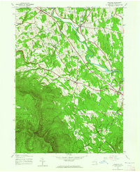
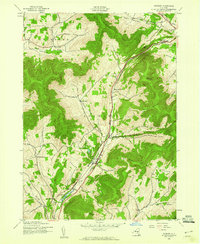
(72)- 1900 Map of Phoenicia, 1963 Print
 1900 Phoenicia1963 Print · USGSThe high Catskills at the turn of the century are captured here in a moment of emerging tourism and mountain settlement. Genealogists and hikers can trace the original locations of the Grand Hotel, the remote Winnisook Lodge, and the rail stops at Mt Pleasant Station.
 - 1901 Map of Margaretville, 1961 Print
 1901 Margaretville1961 Print · USGSThe Catskills at the turn of the century are defined here by river-valley settlements and the Ulster and Delaware railroad line. Genealogists and historians can trace family-named hollows and vanished settlements like Grant Mills, Arena, and Griffin Corners.
 - 1901 Map of Gilboa, 1961 Print
 1901 Gilboa1961 Print · USGSThe northern Catskills at the start of the twentieth century reveal a landscape of river-valley hamlets and high mountain peaks. Genealogists and historians can trace original homesteads near Gilboa, Prattsville, and Livingstonville, or find landmarks like Pratt Rocks.
 - 1903 Map of Gilboa
 1903 Gilboa1903 Print · USGSThe Schoharie Valley at the turn of the century shows a landscape of clustered hamlets and prominent mountain peaks before major regional changes. Researchers can trace the layout of early settlements like Gilboa and Prattsville, or locate family landmarks such as Pratt Rocks and Manorkill Falls.9 unique versions available
 - 1903 Map of Phoenicia
 1903 Phoenicia1903 Print · USGSThe Catskills come alive at the turn of the century, showing the mountain rail corridor and early grand resorts. Researchers can trace the Ulster and Delaware line through Phoenicia to the Highmount Grand Hotel and Winnisook Lodge.9 unique versions available
 - 1903 Map of Kaaterskill, 1906 Print
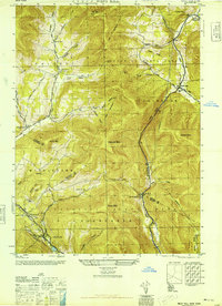
 1903 Kaaterskill1906 Print · USGSThe Catskills come alive in the early twentieth century through this record of mountain resorts and steep-grade rail lines. Researchers can trace the legendary Mountain House, the Otis Elevating R.R., and the remote Dutch Settlement.10 unique versions available
 - 1904 Map of Hobart
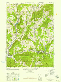
 1904 Hobart1904 Print · USGSThe northern Catskills and Delaware River headwaters come to life in this study of the region just after the turn of the century. You can trace the Ulster and Delaware rail line through high-elevation settlements like Stamford, Hobart, and Roxbury.5 unique versions available
 - 1904 Map of Margaretville
 1904 Margaretville1904 Print · USGSThe Catskills' high-valley communities thrive along the Ulster and Delaware RR at the turn of the century. Trace old family farmsteads and rural mountain hamlets like Arena, New Kingston, and Griffin Corners as they appeared in 1904.7 unique versions available
 - 1929 Map of Coxsackie
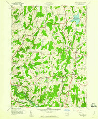
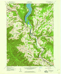
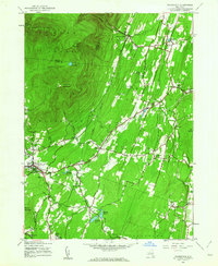
 1929 Coxsackie1929 Print · USGSThe Hudson River valley in the late twenties was a bustling corridor of rail lines and river landings between Albany and Catskill. Genealogists and historians can trace family locations through dozens of numbered schoolhouses, the industrial works at Stottville, and the transit hubs of Schodack Landing and West Coxsackie.4 unique versions available
 - 1934 Map of Catskill, 1960 Print
 1934 Catskill1960 Print · USGSThe Hudson Valley during the mid-1930s shows a landscape of riverfront commerce and deep-rooted rural townships. Genealogists and local historians can locate country schools like Schuylerhook Sch and historic landmarks like the Birthplace of Robert Livingston.2 unique versions available
 - 1938 Map of Catskill
 1938 Catskill1938 Print · USGSThe Hudson Valley in the late thirties remains a landscape of river-side industry and deep colonial heritage. Researchers can trace family sites from Kiskatom Ch to the Birthplace of Robert Livingston or locate vanished local landmarks like Walker Mill.2 unique versions available
 - 1941 Map of Catskill, 1945 Print
 1941 Catskill1945 Print · USGSThe Hudson River valley at the start of the Second World War shows a landscape defined by historic estates and new river crossings. Genealogists and historians can trace the foundations of Bard College, locate the Birthplace of Robert Livingston, and explore early hamlets like Katsbaan and Cheviot.
 - 1943 Map of Freehold, 1964 Print
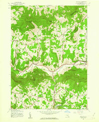
 1943 Freehold1964 Print · USGSThe northern Catskills met the valley settlements of Greene County in the 1940s, showing a landscape of high peaks and rural villages. Researchers can trace family sites near St Marys Ch, Taylor Cem, or along the banks of Catskill Creek.2 unique versions available
 - 1945 Map of Freehold, 1946 Print
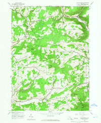
 1945 Freehold1946 Print · USGSGreene County is shown here in the mid-1940s, where the agricultural valleys of the Catskill foothills meet the high peaks of the Escarpment. Researchers can trace family history through local landmarks like Snyder Cem, St Edmunds Chapel, and the hamlets of East Durham and Freehold.
 - 1945 Map of West Kill, 1946 Print
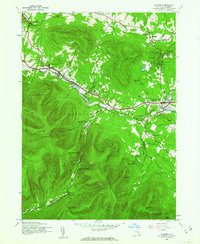
 1945 West Kill1946 Print · USGSThe High Peaks region of the Catskills is captured here at the close of the 1940s, showing a landscape defined by deep valleys and timbered ridges. Genealogists can trace family names and sites like Halcott Cem, Bushnellsville, and several local schoolhouses including School No 2.
 - 1945 Map of Fleischmanns, 1946 Print
 1945 Fleischmanns1946 Print · USGSFleischmanns and the rugged Delaware County highlands are captured here just after the war, showing the mountain hollows and valley settlements in detail. Genealogists can trace family-named sites like Schemehorn Cem, Denver Sch, and the rail stops of the New York Central.4 unique versions available
 - 1945 Map of Greenville, 1960 Print
 1945 Greenville1960 Print · USGSThe Catskill foothills of Albany and Greene Counties appear here at the end of the war, showing a landscape of tight-knit rural hamlets. Researchers can trace family history through landmarks like Smith Corner, Westerlo Central Cem, and School No 6.2 unique versions available
 - 1945 Map of Roxbury, 1960 Print
 1945 Roxbury1960 Print · USGSDelaware County's high valleys and mountain hollows are captured here just after the war, when the river and rail were the lifeblood of the Catskills. Genealogists and historians can trace family locations through Moffit Settlement, the rural Township Ch, and the rail hub at Grand Gorge.4 unique versions available
 - 1945 Map of Prattsville, 1960 Print
 1945 Prattsville1960 Print · USGSThe northern Catskills appear here in the mid-1940s as a landscape of steep ridges and valley settlements tied to the Schoharie Creek. Researchers can trace rural life through sites like School No 1 or family burial grounds such as Huntersfield Cem and Rappleyea Cem.3 unique versions available
 - 1945 Map of Bearsville, 1962 Print
 1945 Bearsville1962 Print · USGSThe Woodstock valley and the surrounding Catskill peaks appear here just after the war, showing a landscape of high summits and valley hamlets. Researchers can trace historic school districts like School No 1 and old settlements at Byrdcliffe and Lake Hill.3 unique versions available
 - 1945 Map of Hunter, 1962 Print
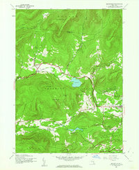
 1945 Hunter1962 Print · USGSThe Greene County highlands in the 1940s show a region shaped by high mountain passes and narrow creek valleys. Genealogists and hikers can trace the foundations of Hunter and Tannersville, locating landmarks like Evergreen Cem and Devils Tombstone.2 unique versions available
 - 1945 Map of Woodstock, 1963 Print
 1945 Woodstock1963 Print · USGSUlster County's mountainous borderlands come into focus at the end of the Second World War as the region's rural character remains largely intact. Genealogists and hikers can trace old property lines and landmarks from West Saugerties to Overlook Mountain, including several legacy schoolhouses like School No 15.4 unique versions available
 - 1945 Map of Ashland, 1963 Print
 1945 Ashland1963 Print · USGSGreene County in the mid-1940s shows a landscape of upland farming and quiet mountain hamlets before modern development altered these rural valleys. Researchers can locate family sites and landmarks like North Settlement Cem, School No 3, and the village of Ashland.3 unique versions available
 - 1945 Map of Livingstonville, 1966 Print
 1945 Livingstonville1966 Print · USGSSchoharie County's mountain valleys were still defined by a network of one-room schoolhouses and small hamlets in the mid-1940s. Researchers can trace ancestral sites like Scott Patent Ch or locate rural districts such as School No 8 and School No 13.2 unique versions available
 - 1945 Map of Hensonville, 1967 Print
 1945 Hensonville1967 Print · USGSThe high peaks of the Catskills meet quiet valley settlements in this mid-1940s survey of Greene County. Local researchers can trace the roads through Hensonville and Maplecrest or locate mountain landmarks like the Lookout Tower and Lake Heloise.
Showing maps 1-25 of 72
Top cities of Greene County
- Catskill historical maps
- Coxsackie historical maps
- Cairo historical maps
- Athens historical maps
- Greenville historical maps
- New Baltimore historical maps
See more
Frequently asked questions
- What are the different types of historical maps available for Greene County?
- What is the oldest map of Greene County?
- Where can I purchase historical maps of Greene County for my home or office?
- Where can I download high-res historical maps of Greene County?
- Are there historical topographic maps available for Greene County?
- Is there historical aerial imagery available for Greene County?
- Where are historical maps of Greene County sourced from?