1960s Maps of Hunter, New York
Explore 3 historic maps of Hunter from the 1960s. These maps offer a rare glimpse into what life looked like during the 1960s — showing old roads, neighborhoods, homes, and landmarks that have changed or disappeared over time.
Whether you're researching your family's past, planning a metal detecting trip, or studying how Hunter's landscape evolved across the 1960s, these high-resolution maps are a powerful tool for exploring the history of this region.
- Focus on a specific era: All maps on this page are from the 1960s, giving you a focused view of this time period.
- See what’s changed: Compare century-old streets, trails, and buildings to today's modern landscape using overlays and satellite layers.
- Research with precision: Use these maps for genealogy, historical research, land use analysis, or educational projects.
- View, download, or print: Maps are fully viewable online in high resolution, and can be downloaded or printed for your own records.
Start exploring Hunter's history through authentic maps from the 1960s. This is your window into the past.
Hunter, NY maps
(3)- 1960 Map of Lexington, 1961 Print
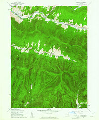 1960 Lexington1961 Print · USGSThe Greene and Ulster County borderlands are surveyed here during the early sixties, showing the high peaks and river hamlets of the Catskills. Genealogists can locate family names at Maplewood Cem or Parker Cem, and trace the route of the Ulster and Delaware Railroad near Lanesville.3 unique versions available
 - 1960 Map of Phoenicia, 1962 Print
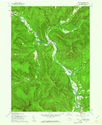 1960 Phoenicia1962 Print · USGSThe Catskill peaks and narrow creek valleys of Ulster County are shown here as they appeared in the early sixties. Genealogists and hikers can trace old homesteads and landmarks like Shandaken Rural Cem, the New York Central line, and Phoenicia.5 unique versions available
 - 1963 Map of Binghamton
 1963 Binghamton1963 Print · USGSThe Southern Tier and Catskill peaks are shown in the early sixties as new reservoirs reshaped the valleys. Trace historic rail corridors like the Erie Lackawanna RR and explore lakeside settlements such as Cooperstown and Oneonta.
End of results
Showing maps 1-3 of 3
Top cities near Hunter
- Kingston historical maps
- Saugerties historical maps
- Ulster historical maps
- Catskill historical maps
- Red Hook historical maps
- Coxsackie historical maps
See more
Top neighborhoods of Hunter
- Elka Park historical maps
- Edgewood historical maps
- Onteora Park historical maps
- Platte Clove Bruderhof historical maps
- Twilight Park historical maps
- Lanesville historical maps
See more
Frequently asked questions
- What are the different types of historical maps available for Hunter?
- What is the oldest map of Hunter?
- Where can I purchase historical maps of Hunter for my home or office?
- Where can I download high-res historical maps of Hunter?
- Are there historical topographic maps available for Hunter?
- Is there historical aerial imagery available for Hunter?
- Where are historical maps of Hunter sourced from?