1990s Maps of Hunter, New York
Explore 4 historic maps of Hunter from the 1990s. These maps offer a rare glimpse into what life looked like during the 1990s — showing old roads, neighborhoods, homes, and landmarks that have changed or disappeared over time.
Whether you're researching your family's past, planning a metal detecting trip, or studying how Hunter's landscape evolved across the 1990s, these high-resolution maps are a powerful tool for exploring the history of this region.
- Focus on a specific era: All maps on this page are from the 1990s, giving you a focused view of this time period.
- See what’s changed: Compare century-old streets, trails, and buildings to today's modern landscape using overlays and satellite layers.
- Research with precision: Use these maps for genealogy, historical research, land use analysis, or educational projects.
- View, download, or print: Maps are fully viewable online in high resolution, and can be downloaded or printed for your own records.
Start exploring Hunter's history through authentic maps from the 1990s. This is your window into the past.
Hunter, NY maps
(4)- 1997 Map of Bearsville, 2001 Print
 1997 Bearsville2001 Print · USGSIn the heart of the Catskills during the late twentieth century, this survey tracks the deep valleys and high peaks surrounding Woodstock. Genealogists and researchers can trace local landmarks like Cooper Lake, Byrdcliffe, and old district sites such as School No 1.
 - 1997 Map of Hunter, 2001 Print
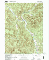
 1997 Hunter2001 Print · USGSThe High Catskills at the close of the twentieth century are captured here, centered on the villages of Hunter and Tannersville. Genealogists and local historians can locate several mountain churches, including St Johns Ch, or trace the legacy of the Old Railroad Grade.
 - 1997 Map of Phoenicia, 2001 Print
 1997 Phoenicia2001 Print · USGSThe Catskills in the late nineties show a landscape shaped by narrow valleys and the winding Esopus Creek. Researchers can trace old family roots at Shandaken Rural Cem or follow the route of the Old Railroad through the hamlet of Phoenicia.
 - 1997 Map of Kaaterskill Clove, 2001 Print
 1997 Kaaterskill Clove2001 Print · USGSThe eastern escarpment of the Catskills is captured here at the close of the millennium, showing the dense network of peaks and ravines that shaped Greene County history. Researchers can trace the Old Railroad Grade through the clove or locate sites like Twilight Park and Mountain House.
End of results
Showing maps 1-4 of 4
Top cities near Hunter
- Kingston historical maps
- Saugerties historical maps
- Ulster historical maps
- Catskill historical maps
- Red Hook historical maps
- Coxsackie historical maps
See more
Top neighborhoods of Hunter
- Elka Park historical maps
- Edgewood historical maps
- Onteora Park historical maps
- Platte Clove Bruderhof historical maps
- Twilight Park historical maps
- Lanesville historical maps
See more
Frequently asked questions
- What are the different types of historical maps available for Hunter?
- What is the oldest map of Hunter?
- Where can I purchase historical maps of Hunter for my home or office?
- Where can I download high-res historical maps of Hunter?
- Are there historical topographic maps available for Hunter?
- Is there historical aerial imagery available for Hunter?
- Where are historical maps of Hunter sourced from?