1990s Maps of Morehouse, New York
Explore 7 historic maps of Morehouse from the 1990s. These maps offer a rare glimpse into what life looked like during the 1990s — showing old roads, neighborhoods, homes, and landmarks that have changed or disappeared over time.
Whether you're researching your family's past, planning a metal detecting trip, or studying how Morehouse's landscape evolved across the 1990s, these high-resolution maps are a powerful tool for exploring the history of this region.
- Focus on a specific era: All maps on this page are from the 1990s, giving you a focused view of this time period.
- See what’s changed: Compare century-old streets, trails, and buildings to today's modern landscape using overlays and satellite layers.
- Research with precision: Use these maps for genealogy, historical research, land use analysis, or educational projects.
- View, download, or print: Maps are fully viewable online in high resolution, and can be downloaded or printed for your own records.
Start exploring Morehouse's history through authentic maps from the 1990s. This is your window into the past.
Morehouse, NY maps
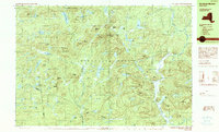
(7)- 1990 Map of Piseco Lake
 1990 Piseco Lake1990 Print · USGSHamilton County's mountain wilderness and quiet lakefront communities are captured here in the 1990s. Genealogists and researchers can trace the small settlements of Piseco and Rudeston alongside landmarks like Higgins Bay and the local Cem.2 unique versions available
 - 1990 Map of West Canada Lakes
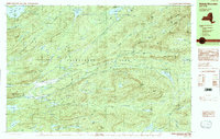
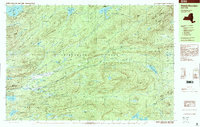
 1990 West Canada Lakes1990 Print · USGSHamilton County's interior wilderness is captured here in the late twentieth century, showing the remote township lines of Arietta and Morehouse. Researchers can trace the network of back-country camps and water routes, from Millers Camp to the expansive Cedar Lakes and the headwaters of West Canada Creek.2 unique versions available
 - 1990 Map of Wakely Mountain
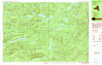
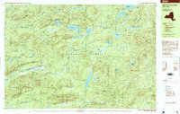
 1990 Wakely Mountain1990 Print · USGSHamilton County remains a high wilderness in the 1990s, defined by its complex river systems and private woodland retreats. Researchers can trace the headwaters of the Moose River and identify landmarks like Wakely Mountain and the Kamp Kill Kare estate.2 unique versions available
 - 1990 Map of Morehouse Mountain
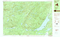
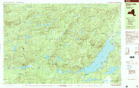
 1990 Morehouse Mountain1990 Print · USGSThe Adirondack wilderness of Hamilton, Herkimer, and Fulton counties is shown here in the late twentieth century. Researchers can trace the legacy of mountain life and prospecting through landmarks like Big Goldmine Hill, Powley Place, and Clockmill Corners.
 - 1997 Map of Piseco Lake
 1997 Piseco Lake1997 Print · USGSThe Adirondack forest preserve in the late nineties centers on the waters of Piseco Lake and the Metcalf Range. Researchers can trace the layout of Piseco, Rudeston, and Higgins Bay, or locate remote sites like Mountain Home and the local Cem.
 - 1997 Map of West Canada Lakes, 1999 Print
 1997 West Canada Lakes1999 Print · USGSHamilton County in the late nineties is documented as a pristine wilderness within the Adirondack Park. Hikers and local historians can trace remote outposts like Millers Camp and the intricate headwaters of West Canada Creek Stillwater.
 - 1997 Map of Wakely Mountain, 2000 Print
 1997 Wakely Mountain2000 Print · USGSArietta and the surrounding Hamilton County wilderness are captured in the late nineties, documenting the remote forest camps and vast water systems of the Adirondacks. Researchers can trace the grounds of Kamp Kill Kare or locate hidden waters like Helldiver Pond and Little Moose Lake.
End of results
Showing maps 1-7 of 7
Top cities near Morehouse
- Salisbury historical maps
- Webb historical maps
- Indian Lake historical maps
- Ohio historical maps
- Lake Pleasant historical maps
- Norway historical maps
See more
Top neighborhoods of Morehouse
Frequently asked questions
- What are the different types of historical maps available for Morehouse?
- What is the oldest map of Morehouse?
- Where can I purchase historical maps of Morehouse for my home or office?
- Where can I download high-res historical maps of Morehouse?
- Are there historical topographic maps available for Morehouse?
- Is there historical aerial imagery available for Morehouse?
- Where are historical maps of Morehouse sourced from?