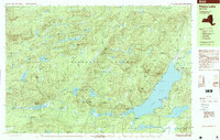
1997 Map of Piseco Lake
USGS Topo · Published 1997About this map
Adirondack Park lands dominate this late-twentieth-century study of Hamilton County, where the topography transitions from the high peaks of the Metcalf Range to the broad waters of Piseco Lake. The settlement of Piseco and the nearby Rudeston area serve as the primary hubs of activity along the eastern shore, supported by a Boat Ramp and the local Cem that anchors the community's history.
Find a feature on this map
80 named features on this map. Tap any name to fly to it.
Don’t see what you’re looking for? This feature index may not catch every label — zoom into the map to look around manually.
Map Details
Editions of this 1997 Piseco Lake Map
This is the sole edition of this map. No revisions or reprints were ever made.
Other maps of this area

1899 · Indian Lake
USGS Topo · 1:62,500

1900 · Canada Lake
USGS Topo · 1:62,500

1900 · Wilmurt
USGS Topo · 1:62,500

1901 · Old Forge
USGS Topo · 1:62,500

1902 · Wilmurt
USGS Topo · 1:62,500

1902 · Indian Lake
USGS Topo · 1:62,500

1903 · West Canada Lakes
USGS Topo · 1:62,500

1904 · Piseco Lake
USGS Topo · 1:62,500

1906 · Piseco Lake
USGS Topo · 1:62,500

1907 · Lake Pleasant
USGS Topo · 1:62,500