1950s Maps of Webster, New York
Explore 3 historic maps of Webster from the 1950s. These maps offer a rare glimpse into what life looked like during the 1950s — showing old roads, neighborhoods, homes, and landmarks that have changed or disappeared over time.
Whether you're researching your family's past, planning a metal detecting trip, or studying how Webster's landscape evolved across the 1950s, these high-resolution maps are a powerful tool for exploring the history of this region.
- Focus on a specific era: All maps on this page are from the 1950s, giving you a focused view of this time period.
- See what’s changed: Compare century-old streets, trails, and buildings to today's modern landscape using overlays and satellite layers.
- Research with precision: Use these maps for genealogy, historical research, land use analysis, or educational projects.
- View, download, or print: Maps are fully viewable online in high resolution, and can be downloaded or printed for your own records.
Start exploring Webster's history through authentic maps from the 1950s. This is your window into the past.
Webster, NY maps
(3)- 1952 Map of Ninemile Point
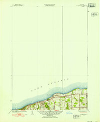 1952 Ninemile Point1952 Print · USGSThe Lake Ontario shoreline of Webster comes into focus in the early fifties, capturing a landscape of family farms and lakeside recreation. Researchers can trace local heritage at Union Cem, School No 18, and Webster Beach County Park.3 unique versions available
 - 1952 Map of Rochester East, 1954 Print
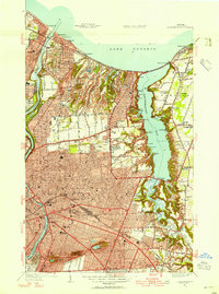 1952 Rochester East1954 Print · USGSThe Lake Ontario shoreline and the bustling eastern half of Rochester are captured here in the early fifties. Genealogists and local historians can locate specific neighborhood institutions like Indian Landing School, Twelve Corners, and the historic Float Bridge.3 unique versions available
 - 1952 Map of Webster, 1964 Print
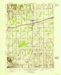 1952 Webster1964 Print · USGSMonroe County enters a period of post-war growth as early hamlets and rural school districts begin to transition into modern suburbs. Genealogists and local historians can trace family locations near Oakwood Cem, the East Penfield Church, or the unique terrain of Thousand Acre Swamp.3 unique versions available
End of results
Showing maps 1-3 of 3
Top cities near Webster
- Rochester historical maps
- Greece historical maps
- Irondequoit historical maps
- Perinton historical maps
- Henrietta historical maps
- Penfield historical maps
See more
Top neighborhoods of Webster
- Oklahoma Beach historical maps
- Forest Lawn historical maps
- West Webster historical maps
- Glen Edith historical maps
- Webster historical maps
Frequently asked questions
- What are the different types of historical maps available for Webster?
- What is the oldest map of Webster?
- Where can I purchase historical maps of Webster for my home or office?
- Where can I download high-res historical maps of Webster?
- Are there historical topographic maps available for Webster?
- Is there historical aerial imagery available for Webster?
- Where are historical maps of Webster sourced from?