1970s Maps of Webster, New York
Explore 3 historic maps of Webster from the 1970s. These maps offer a rare glimpse into what life looked like during the 1970s — showing old roads, neighborhoods, homes, and landmarks that have changed or disappeared over time.
Whether you're researching your family's past, planning a metal detecting trip, or studying how Webster's landscape evolved across the 1970s, these high-resolution maps are a powerful tool for exploring the history of this region.
- Focus on a specific era: All maps on this page are from the 1970s, giving you a focused view of this time period.
- See what’s changed: Compare century-old streets, trails, and buildings to today's modern landscape using overlays and satellite layers.
- Research with precision: Use these maps for genealogy, historical research, land use analysis, or educational projects.
- View, download, or print: Maps are fully viewable online in high resolution, and can be downloaded or printed for your own records.
Start exploring Webster's history through authentic maps from the 1970s. This is your window into the past.
Webster, NY maps
(3)- 1971 Map of Ninemile Point, 1973 Print
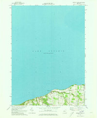 1971 Ninemile Point1973 Print · USGSThe Lake Ontario shoreline in Monroe County appears in the early 1970s as a blend of recreational parkland and quiet residential roads. Trace family roots at Union Cem or explore the coastal drainages of Fourmile Creek and Ninemile Point.2 unique versions available
 - 1971 Map of Webster, 1974 Print
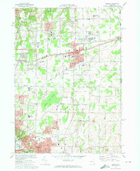 1971 Webster1974 Print · USGSMonroe County enters a decade of growth in the early seventies as the suburban landscape expands around Webster and Penfield. Researchers can trace local heritage through numerous historic sites, including Webster Rural Cem, Oakwood Cem, and the Penn Central rail lines.3 unique versions available
 - 1971 Map of Rochester East, 1974 Print
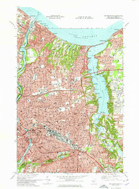 1971 Rochester East1974 Print · USGSGreater Rochester and the Irondequoit shoreline are shown in the early 1970s, as the city's northern suburbs reached their modern footprint. Genealogists can locate family landmarks from Riverside Cemetery to Brighton or trace the old rail lines of the Penn Central.3 unique versions available
End of results
Showing maps 1-3 of 3
Top cities near Webster
- Rochester historical maps
- Greece historical maps
- Irondequoit historical maps
- Perinton historical maps
- Henrietta historical maps
- Penfield historical maps
See more
Top neighborhoods of Webster
- Oklahoma Beach historical maps
- Forest Lawn historical maps
- West Webster historical maps
- Glen Edith historical maps
- Webster historical maps
Frequently asked questions
- What are the different types of historical maps available for Webster?
- What is the oldest map of Webster?
- Where can I purchase historical maps of Webster for my home or office?
- Where can I download high-res historical maps of Webster?
- Are there historical topographic maps available for Webster?
- Is there historical aerial imagery available for Webster?
- Where are historical maps of Webster sourced from?