1990s Maps of Orange County, New York
Explore 9 historic maps of Orange County from the 1990s. These maps offer a rare glimpse into what life looked like during the 1990s — showing old roads, neighborhoods, homes, and landmarks that have changed or disappeared over time.
Whether you're researching your family's past, planning a metal detecting trip, or studying how Orange County's landscape evolved across the 1990s, these high-resolution maps are a powerful tool for exploring the history of this region.
- Focus on a specific era: All maps on this page are from the 1990s, giving you a focused view of this time period.
- See what’s changed: Compare century-old streets, trails, and buildings to today's modern landscape using overlays and satellite layers.
- Research with precision: Use these maps for genealogy, historical research, land use analysis, or educational projects.
- View, download, or print: Maps are fully viewable online in high resolution, and can be downloaded or printed for your own records.
Start exploring Orange County's history through authentic maps from the 1990s. This is your window into the past.
Orange County, NY maps
(9)- 1992 Map of Pond Eddy, 1994 Print
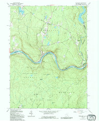 1992 Pond Eddy1994 Print · USGSAlong the winding border of New York and Pennsylvania in the 1990s, this area shows a landscape of river-bend settlements and state forests. Genealogists can locate Pond Eddy and Glen Spey, or trace family sites at Hillside Cem and Sacred Heart Ch.
 - 1992 Map of Port Jervis North, 1994 Print
 1992 Port Jervis North1994 Print · USGSThe tri-state border region comes alive in this late twentieth-century study of the confluence of the Delaware and Neversink Rivers. Researchers can trace the path of the Erie Lackawanna railroad or locate family sites at Paradise Cem and the village of Sparrow Bush.
 - 1993 Map of Waterbury
 1993 Waterbury1993 Print · USGSWestern Connecticut and the Hudson Valley appear in the early nineties as a landscape of established industrial cities and deep forest preserves. Researchers can trace the rail corridors of the Metro-North Railroad or locate family sites near the Taft School and Riverside Cemetery.
 - 1994 Map of Wawayanda, 1998 Print
 1994 Wawayanda1998 Print · USGSThe Highlands of northern New Jersey meet the New York border in the 1990s, where protected forests and ridge-top trails define the landscape. Trace the Appalachian Trail past Highland Lakes or locate family roots near Glenwood Cem and Greenwood Ch.
 - 1994 Map of Popolopen Lake, 1999 Print
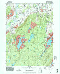
 1994 Popolopen Lake1999 Print · USGSOrange and Rockland counties appear in the mid-1990s as a haven of state parks and West Point training grounds. Genealogists and hikers can trace old valley roads to the Quaker Meetinghouse, the Silver Mine, and the site of Doodletown.
 - 1994 Map of Cornwall-on-Hudson, 2000 Print
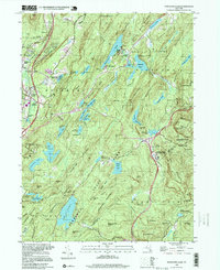
 1994 Cornwall-on-Hudson2000 Print · USGSThe Hudson Highlands meet the river in the mid-1990s, where steep ridgelines overlook a landscape shaped by military history and regional infrastructure. Genealogists and historians can trace institutional sites like the N Y Mil Academy, Epiphany Apostolic College, and burial grounds at Calvary Cemetery.
 - 1995 Map of Port Jervis South, 2000 Print
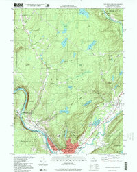
 1995 Port Jervis South2000 Print · USGSThe tri-state border region around the turn of the millennium shows the dense riverfront settlement of Port Jervis giving way to the high ridges of Kittatinny Mountain. Researchers can trace local landmarks like St Francis Hospital or explore the wilderness paths of the Appalachian Trail.
 - 1997 Map of Port Jervis North, 1999 Print
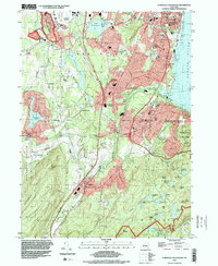
 1997 Port Jervis North1999 Print · USGSPort Jervis sits at the vital junction of the Delaware and Neversink rivers in the late 1990s, where New York meets Pennsylvania. Researchers can trace the industrial footprint of the Erie RR and locate local landmarks like Paradise Cem and the Hawks Nest.
 - 1997 Map of Pond Eddy, 1999 Print
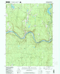 1997 Pond Eddy1999 Print · USGSThe Delaware River valley at the close of the twentieth century remains a landscape of high ridges and protected forests across the New York-Pennsylvania line. Genealogists and historians can locate family landmarks like Hillside Cem and Sacred Heart Ch or trace the riverfront hamlets of Pond Eddy and Knights Eddy.
End of results
Showing maps 1-9 of 9
Top cities of Orange County
- Palm Tree historical maps
- Kiryas Joel historical maps
- Warwick historical maps
- Newburgh historical maps
- Wallkill historical maps
- Middletown historical maps
See more
Frequently asked questions
- What are the different types of historical maps available for Orange County?
- What is the oldest map of Orange County?
- Where can I purchase historical maps of Orange County for my home or office?
- Where can I download high-res historical maps of Orange County?
- Are there historical topographic maps available for Orange County?
- Is there historical aerial imagery available for Orange County?
- Where are historical maps of Orange County sourced from?