1940s Maps of Orange County, New York
Explore 39 historic maps of Orange County from the 1940s. These maps offer a rare glimpse into what life looked like during the 1940s — showing old roads, neighborhoods, homes, and landmarks that have changed or disappeared over time.
Whether you're researching your family's past, planning a metal detecting trip, or studying how Orange County's landscape evolved across the 1940s, these high-resolution maps are a powerful tool for exploring the history of this region.
- Focus on a specific era: All maps on this page are from the 1940s, giving you a focused view of this time period.
- See what’s changed: Compare century-old streets, trails, and buildings to today's modern landscape using overlays and satellite layers.
- Research with precision: Use these maps for genealogy, historical research, land use analysis, or educational projects.
- View, download, or print: Maps are fully viewable online in high resolution, and can be downloaded or printed for your own records.
Start exploring Orange County's history through authentic maps from the 1940s. This is your window into the past.
Orange County, NY maps
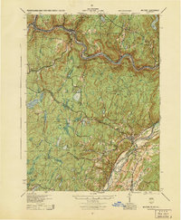
(39)- 1941 Map of West Point
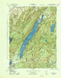
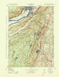
 1941 West Point1941 Print · USGSThe Hudson Highlands were undergoing significant change in the years leading up to the war, blending heavy industry with expanding military installations. Genealogists can trace family lines through Continental Village, Hillside Cem, and the various schools like Manitou Sch.3 unique versions available
 - 1941 Map of West Point, 1951 Print
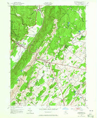
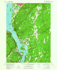 1941 West Point1951 Print · USGSThe Hudson Highlands are captured here in the mid-1950s as the river-and-rail economy defined life in Beacon and Cold Spring. Researchers can trace the grounds of the U S Military Academy West Point, locating the U S Silver Depository and Constitution Island.
 - 1942 Map of Pine Island, 1954 Print
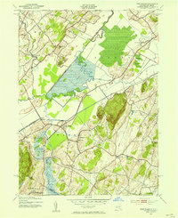 1942 Pine Island1954 Print · USGSThe Orange County lowlands were a hub of rail and drainage engineering during the early 1940s. Researchers can trace the path of the Erie and Lehigh and New England railroads as they pass through rural hamlets like Pine Island, Edenville, and Snufftown.2 unique versions available
 - 1942 Map of Goshen, 1956 Print
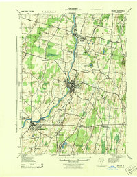
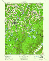
 1942 Goshen1956 Print · USGSOrange County's agricultural and rail infrastructure is well-defined in the early 1940s as local hubs like Goshen and Campbell Hall expand. Genealogists and researchers can locate landmarks like Bordens Dairy, Blessed Sacrament Academy, and the Wallkill Cemetery.
 - 1942 Map of Port Jervis North, 1958 Print
 1942 Port Jervis North1958 Print · USGSThe tri-state border region near Port Jervis is shown here during the early war years, when the local economy centered on the river and heavy rail. Genealogists can trace family footprints near Sparrow Bush, Millrift, and several rural schoolhouses like Huguenot Sch No 2.2 unique versions available
 - 1942 Map of Walden, 1958 Print
 1942 Walden1958 Print · USGSOrange County's Wallkill Valley at the height of the war era reveals a landscape of riverside industry and family-owned dairy farms. Genealogists and local historians can trace legacy sites like the Borden Estate, Montgomery Worsted Mills, and Goodwill Church.
 - 1942 Map of Middletown, 1959 Print
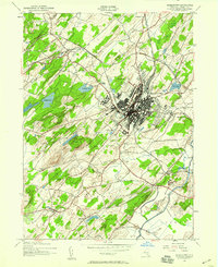 1942 Middletown1959 Print · USGSOrange County's industrial and institutional landscape is captured here during the 1940s as the rail networks of the ERIE and NEW YORK AND WESTERN converge. Genealogists and local historians can trace family locations near Hillside Cemetery, the State Hospital, or old rural schoolhouses like Wallkill School No 11.
 - 1942 Map of Otisville, 1959 Print
 1942 Otisville1959 Print · USGSWestern Orange County during the early 1940s shows a landscape shaped by mountain ridges and the intersecting lines of the Erie RR and the New York Ontario and Western RR. Genealogists can locate family landmarks such as Mount Hope Cem or the local Godeffroy Sch.
 - 1943 Map of Port Jervis North
 1943 Port Jervis North1943 Print · USGSThe Delaware River valley north of Port Jervis appears here in the early 1940s, showing a landscape defined by mountain ridges and river industry. Genealogists can locate family landmarks like Eddys Farm or trace the early footprint of the Huguenot Airport and the Deerpark Brewery.
 - 1943 Map of Unionville
 1943 Unionville1943 Print · USGSThe Orange County and Sussex County borderlands come alive in the early 1940s, showing a landscape shaped by rail lines and river valleys. Researchers can trace the industrial footprints of the American Silk Label Co or locate family roots near Minisink Cemetery and Westtown School.
 - 1943 Map of Poughkeepsie
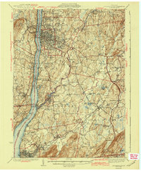 1943 Poughkeepsie1943 Print · USGSThe mid-Hudson valley is captured here in the years during the Second World War, showing the busy corridor between Poughkeepsie and Beacon. Researchers can trace old institutional lands like Vassar College or locate vanished rural schools such as Swede Sch and Devine Sch.3 unique versions available
 - 1943 Map of Goshen
 1943 Goshen1943 Print · USGSOrange County's agricultural and rail infrastructure is captured here during the Second World War as the region supported local industry and institutions. Genealogists can locate family landmarks like Bordens Dairy, the Sara Wells Airport, and schools such as Our Lady of the Blessed Sacrament Academy.
 - 1943 Map of Greenwood Lake
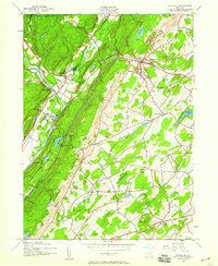
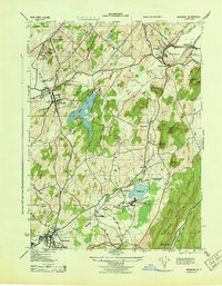
 1943 Greenwood Lake1943 Print · USGSGreenwood Lake and the surrounding Highlands are captured during the early 1940s, revealing a landscape defined by iron industry and lakeside settlement. Genealogists and researchers can locate the Ringwood Iron Plant Mine, St Francis School, and the Erie Ringwood Branch railroad.
 - 1943 Map of Otisville
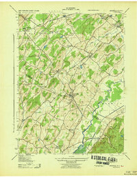
 1943 Otisville1943 Print · USGSOrange and Sullivan Counties are shown in the 1940s as a hub of rail infrastructure and public health institutions. Researchers can trace the legacy of the N Y City Municipal Sanatorium, the Erie RR corridor, and local landmarks like Mount Hope Cemetery.
 - 1943 Map of Wawayanda
 1943 Wawayanda1943 Print · USGSThe New York and New Jersey borderlands appear here in the early 1940s as a landscape of highland lakes and valley rail stops. Genealogists and local historians can trace the transit corridor of the Lehigh and Hudson River railroad and locate old rural landmarks like the New Milford School and Maple Grange.2 unique versions available
 - 1943 Map of Napanoch
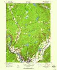
 1943 Napanoch1943 Print · USGSThe Shawangunk Mountains and the valley of the Rondout Creek are captured here in the early 1940s. Genealogists and historians can trace family properties like V Mahon and H Hall or locate rural landmarks such as Crawford Church and the Union District School.
 - 1943 Map of Walden
 1943 Walden1943 Print · USGSOrange County's riverfront villages and dairy heritage are captured here in the early 1940s. Genealogists can locate family landmarks like the Borden Estate or St Marys Cemetery, while tracing the paths of the Wallkill Valley Branch railroad.
 - 1943 Map of Port Jervis South
 1943 Port Jervis South1943 Print · USGSThe tri-state borderlands during the Second World War reveal a landscape of river-valley industry and upland retreats. Researchers can trace the ERIE railroad through Port Jervis or locate historical sites like the Life Magazine Camp and Tristate Bible Camp.3 unique versions available
 - 1943 Map of Pine Island
 1943 Pine Island1943 Print · USGSThe fertile black dirt region of the New York-New Jersey border is captured here during the 1940s, showing a landscape defined by rail transit and river engineering. Genealogists and local historians can trace the foundations of Pine Island, locate the St Stanislaus Ch, or follow the industrial footprint of the Universal Atlas Cement Co.
 - 1943 Map of Warwick
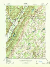
 1943 Warwick1943 Print · USGSOrange County's agricultural and rail heartland is captured here during the mid-forties, showing the vital corridors between Warwick and Chester. Genealogists and researchers can locate the County Poor Farm, trace the ERIE railroad, and find local landmarks like Chester Academy and Albany School.2 unique versions available
 - 1943 Map of Pinebush, 1944 Print
 1943 Pinebush1944 Print · USGSThe rural borderlands of Orange and Ulster counties come alive in the 1940s, anchored by the rail hub at Pinebush. Genealogists can trace family homesteads like C. Judson and M. Durnin or locate landmarks like the Brimstone School and Hopewell Cemetery.
 - 1943 Map of Wurtsboro, 1954 Print
 1943 Wurtsboro1954 Print · USGSSullivan and Orange County hillsides were undergoing a transit transition during the early years of the war. Researchers can trace the legacy of the Delaware and Hudson Canal, find family names at Sylvan Cem, and locate rural landmarks like Prosperous Valley Sch.3 unique versions available
 - 1943 Map of Monticello, 1961 Print
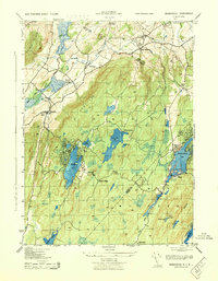
 1943 Monticello1961 Print · USGSSullivan County's resort and rail corridor comes into focus in the 1940s, highlighting the area's transition into a premier vacation destination. Local historians can trace the paths of the New York Ontario and Western RR and find specific seasonal hubs like Luzon Sta or the private Merriewold Park.3 unique versions available
 - 1943 Map of Monticello, 1964 Print
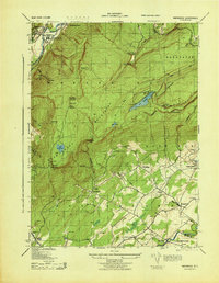
 1943 Monticello1964 Print · USGSSullivan County in the early 1940s is shown at a peak of its rural development before mid-century modernization changed the landscape. Genealogists and researchers can trace local roots through numerous district schools like the Bushville School and family landmarks such as the Stewart Cem or the industrial Dye Works.
 - 1944 Map of Milford
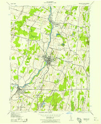
 1944 Milford1944 Print · USGSThe tri-state Delaware River valley was a network of river-bound hamlets and upland schools during the 1940s. Genealogists and local historians can trace family locations through named sites like Dark Swamp Sch, Mongaup Sta, and Quicktown.
Showing maps 1-25 of 39
Top cities of Orange County
- Palm Tree historical maps
- Kiryas Joel historical maps
- Warwick historical maps
- Newburgh historical maps
- Wallkill historical maps
- Middletown historical maps
See more
Frequently asked questions
- What are the different types of historical maps available for Orange County?
- What is the oldest map of Orange County?
- Where can I purchase historical maps of Orange County for my home or office?
- Where can I download high-res historical maps of Orange County?
- Are there historical topographic maps available for Orange County?
- Is there historical aerial imagery available for Orange County?
- Where are historical maps of Orange County sourced from?